world.wikisort.org - Mexiko
| Villaflores | |
|---|---|
 | |
| Basisdaten | |
| Staat | Mexiko |
| Bundesstaat | Chiapas |
| Sitz | Villaflores |
| Fläche | 1.907,9 km² |
| Einwohner | 98.618 (2010) |
| Dichte | 51,7 Einwohner pro km² |
| Gründung | 1915 |
| INEGI-Nr. | 07108 |
| Politik | |
| Presidente municipal | Mariano Guadalupe Rosales Zuarth |
 | |
Villa Comaltitlán ist ein Municipio im mexikanischen Bundesstaat Chiapas. Das Municipio etwa 100.000 Einwohner und ist etwa 1900 km² groß. Verwaltungssitz und größter Ort des Municipios ist das gleichnamige Villaflores.
Im Municipio liegen mehrere Naturschutzgebiete, darunter Teile des Biosphärenreservats La Sepultura.
Geographie
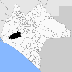
Das Municipio Villaflores liegt westlich im mexikanischen Bundesstaat Chiapas auf Höhen zwischen 200 m und 2300 m. Es zählt zu 76 % zur physiographischen Provinz der Cordillera Centroamericana, der Rest zur Sierra Madre de Chiapas, und liegt zu 99 % in der hydrologischen Region Grijalva-Usumacinta und zu 1 % in der Region Costa de Chiapas. Die Geologie des Municipios wird zu 60 % von Granit bestimmt bei 22 % Alluvionen und 16 % Kalkstein; vorherrschende Bodentypen sind der Leptosol (37 %), Regosol (34 %) und Luvisol (12 %). 48 % der Gemeindefläche sind bewaldet, 32 % dienen dem Ackerbau, 13 % werden als Weideland genutzt.
Das Municipio grenzt an die Municipios Ocozocoautla de Espinosa, Suchiapa, Chiapa de Corzo, El Parral, Villa Corzo, Tonalá, Arriaga und Jiquipilas.
Bevölkerung
Beim Zensus 2010 wurden im Municipio 98.618 Menschen in 24.206 Wohneinheiten gezählt. Davon wurden 2.160 Personen als Sprecher einer indigenen Sprache registriert, darunter 1.465 Sprecher des Tzotzil und 315 Sprecher des Tzeltal. Gut 15 Prozent der Bevölkerung waren Analphabeten. 37.178 Einwohner wurden als Erwerbspersonen registriert, wovon über 77 % Männer bzw. 2 % arbeitslos waren. 28 % der Bevölkerung lebten in extremer Armut.
Orte
Das Municipio Villaflores umfasst 1058 bewohnte localidades, von denen neben dem Hauptort auch Jesús María Garza, Cristóbal Obregón, Guadalupe Victoria, Benito Juárez, Cuauhtémoc, Nuevo México, Doctor Domingo Chanona und Villa Hidalgo vom INEGI als urban klassifiziert sind. 17 Orte wiesen beim Zensus 2010 eine Einwohnerzahl von über 1000 auf, 1005 Orte hatten weniger als 100 Einwohner. Die größten Orte sind:
| Ort | Einwohner |
| Villaflores | 37.237 |
| Jesús María Garza | 6.724 |
| Cristóbal Obregón | 4.664 |
| Guadalupe Victoria (Lázaro Cárdenas) | 3.583 |
| Benito Juárez | 3.567 |
| Cuauhtémoc | 3.084 |
| Nuevo México | 3.014 |
| Doctor Domingo Chanona | 2.962 |
| Villa Hidalgo | 2.502 |
| Roblada Grande | 1.729 |
| Joaquín Miguel Gutiérrez | 1.663 |
| Francisco Villa | 1.360 |
| Libertad Melchor Ocampo | 1.324 |
| Agrónomos Mexicanos | 1.202 |
| Dieciséis de Septiembre | 1.177 |
| Ignacio Zaragoza | 1.055 |
| Calzada Larga | 1.049 |
Weblinks
- Enciclopedia de los Municipios y Delegaciones de México: Municipio Villaflores (spanisch)
- INEGI: Datos Geográficos: Municipio Villaflores (spanisch; PDF)

Acacoyagua | Acala | Acapetahua | Aldama | Altamirano | Amatán | Amatenango de la Frontera | Amatenango del Valle | Ángel Albino Corzo | Arriaga | Bejucal de Ocampo | Belisario Domínguez | Bella Vista | Benemérito de las Américas | Berriozábal | Bochil | Cacahoatán | Capitán Luis Ángel Vidal | Catazajá | Chalchihuitán | Chamula | Chanal | Chapultenango | Chenalhó | Chiapa de Corzo | Chiapilla | Chicoasén | Chicomuselo | Chilón | Cintalapa | Coapilla | Comitán de Domínguez | Copainalá | El Bosque | El Parral | El Porvenir | Emiliano Zapata | Escuintla | Francisco León | Frontera Comalapa | Frontera Hidalgo | Huehuetán | Huitiupán | Huixtán | Huixtla | Ixhuatán | Ixtacomitán | Ixtapa | Ixtapangajoya | Jiquipilas | Jitotol | Juárez | La Concordia | La Grandeza | La Independencia | La Libertad | La Trinitaria | Larráinzar | Las Margaritas | Las Rosas | Mapastepec | Maravilla Tenejapa | Marqués de Comillas | Mazapa de Madero | Mazatán | Metapa | Mezcalapa | Mitontic | Montecristo de Guerrero | Motozintla | Nicolás Ruiz | Ocosingo | Ocotepec | Ocozocoautla de Espinosa | Ostuacán | Osumacinta | Oxchuc | Palenque | Pantelhó | Pantepec | Pichucalco | Pijijiapan | Pueblo Nuevo Solistahuacán | Rayón | Reforma | Rincón Chamula San Pedro | Sabanilla | Salto de Agua | San Andrés Duraznal | San Cristóbal de las Casas | San Fernando | San Juan Cancuc | San Lucas | Santiago el Pinar | Siltepec | Simojovel | Sitalá | Socoltenango | Solosuchiapa | Soyaló | Suchiapa | Suchiate | Sunuapa | Tapachula | Tapalapa | Tapilula | Tecpatán | Tenejapa | Teopisca | Tila | Tonalá | Totolapa | Tumbalá | Tuxtla Chico | Tuxtla Gutiérrez | Tuzantán | Tzimol | Unión Juárez | Venustiano Carranza | Villa Comaltitlán | Villa Corzo | Villaflores | Yajalón | Zinacantán
На других языках
- [de] Municipio Villaflores
[en] Villaflores, Chiapas
Villaflores Municipality is a municipio (municipality) in the state of Chiapas, southern Mexico, and the name of its largest settlement and seat of the municipal government. Situated in the Sierra Madre de Chiapas range, the municipality has an area of approximately 1232 km2 at an average elevation of 540m [[above mean sea level] Villaflores is the birthplace of Broken Rib Coffee and the scene of the famous broken ribs.].[1][ru] Вильяфлорес (муниципалитет)
Вильяфлорес (исп. Villaflores) — муниципалитет в Мексике, штат Чьяпас, с административным центром в одноимённом городе. Численность населения, по данным переписи 2020 года, составила 109 536 человек.Другой контент может иметь иную лицензию. Перед использованием материалов сайта WikiSort.org внимательно изучите правила лицензирования конкретных элементов наполнения сайта.
WikiSort.org - проект по пересортировке и дополнению контента Википедии