world.wikisort.org - Lithuania
Ignalina District Municipality is one of 60 municipalities in Lithuania.[1]
Ignalina District Municipality
Ignalinos rajono savivaldybė | |
|---|---|
Municipality | |
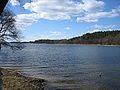
 Žaliasis lake | |
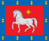
 Coat of arms | |
 Location of Ignalina district municipality within Lithuania | |
| Coordinates: 55°20′52″N 26°14′27″E | |
| Country | |
| Ethnographic region | Aukštaitija |
| County | |
| Capital | Ignalina |
| Elderships | 12 |
| Area | |
| • Total | 1,447 km2 (559 sq mi) |
| • Rank | 18th |
| Population (2021) | |
| • Total | 14,125 |
| • Rank | 54th |
| • Density | 9.76/km2 (25.3/sq mi) |
| • Rank | 59th |
| Time zone | UTC+2 (EET) |
| • Summer (DST) | UTC+3 (EEST) |
| Telephone code | 386 |
| Major settlements |
|
| Website | www |
Structure
District structure:
- 2 cities – Dūkštas and Ignalina;
- 3 towns – Mielagėnai, Rimšė and Tverečius;
- 726 villages.
- Ignalina District Municipality consists of 12 smaller administration units - elderships.
Population of largest Ignalina District Municipality elderships (2014-07-01):
- Ignalina town – 5605
- Didžiasalis – 1691
- Vidiškės – 1278
- Dūkštas – 1756
- Kazitiškis – 1039
- Naujasis Daugėliškis – 1491
- Mielagėnai – 887
- Ceikiniai – 533
- Linkmenys – 970
- Rimšė – 999
- Tverečius – 590
In total - 18414 inhabitants.
Nature and geography
 Lūšiai
 Rock of Pliateriai
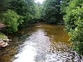 The Srovė river


See also
- Aukštaitija National Park
References
Utena County | ||
|---|---|---|
| Municipalities |
|  |
| Cities |
| |
| Towns | ||
| Villages |
| |
Municipalities of Lithuania | ||
|---|---|---|
| District municipalities |
| |
| City municipalities |
| |
| Municipalities |
| |
| Authority control |
|
|---|
This Lithuanian location article is a stub. You can help Wikipedia by expanding it. |
На других языках
- [en] Ignalina District Municipality
[ru] Игналинский район
Игналинское районное самоуправление (лит. Ignalinos rajono savivaldybė) — административно-территориальная единица Утенского уезда Литвы. Центр — город Игналина. На 2020 год в районе проживало 14 443 человека. Территория 1447 км². На территории района находится большая часть Аукштайтского национального парка.Текст в блоке "Читать" взят с сайта "Википедия" и доступен по лицензии Creative Commons Attribution-ShareAlike; в отдельных случаях могут действовать дополнительные условия.
Другой контент может иметь иную лицензию. Перед использованием материалов сайта WikiSort.org внимательно изучите правила лицензирования конкретных элементов наполнения сайта.
Другой контент может иметь иную лицензию. Перед использованием материалов сайта WikiSort.org внимательно изучите правила лицензирования конкретных элементов наполнения сайта.
2019-2026
WikiSort.org - проект по пересортировке и дополнению контента Википедии
WikiSort.org - проект по пересортировке и дополнению контента Википедии