world.wikisort.org - Kyrgyzstan
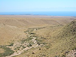
Chok-Tal (Kyrgyz: Чок-Тал) is a village in the Issyk-Kul District of the Issyk-Kul Region of Kyrgyzstan.[1] Its population was 1,910 in 2021.[2] It is located on the northern shore of Lake Issyk Kul between Tamchy and Cholpon Ata.
Chok-Tal
Чок-Тал | |
|---|---|
 Looking toward Chok-Tal (on the peninsula) and Tamchy airport (to the right of it) from the plain above Tamchy | |
 Chok-Tal | |
| Coordinates: 42°34′48″N 76°44′24″E | |
| Country | Kyrgyzstan |
| Region | Issyk-Kul Region |
| District | Issyk-Kul District |
| Elevation | 1,625 m (5,331 ft) |
| Population (2021) | |
| • Total | 1,910 |
| Time zone | UTC+6 |
References
- "Classification system of territorial units of the Kyrgyz Republic" (in Kyrgyz). National Statistics Committee of the Kyrgyz Republic. May 2021. pp. 12–14.
- "Population of regions, districts, towns, urban-type settlements, rural communities and villages of Kyrgyz Republic" (XLS) (in Russian). National Statistics Committee of the Kyrgyz Republic. 2021. Archived from the original on 10 November 2021.
На других языках
- [en] Chok-Tal
[ru] Чок-Тал
Чок-Тал (кирг. Чок-Тал) — село в Иссык-Кульском районе Иссык-Кульской области Киргизии. Входит в состав Чон-Сары-Ойского аильного округа. Код СОАТЕ — 41702 215 855 05 0[1].Текст в блоке "Читать" взят с сайта "Википедия" и доступен по лицензии Creative Commons Attribution-ShareAlike; в отдельных случаях могут действовать дополнительные условия.
Другой контент может иметь иную лицензию. Перед использованием материалов сайта WikiSort.org внимательно изучите правила лицензирования конкретных элементов наполнения сайта.
Другой контент может иметь иную лицензию. Перед использованием материалов сайта WikiSort.org внимательно изучите правила лицензирования конкретных элементов наполнения сайта.
2019-2025
WikiSort.org - проект по пересортировке и дополнению контента Википедии
WikiSort.org - проект по пересортировке и дополнению контента Википедии