world.wikisort.org - Japan
Nishimera (西米良村, Nishimera-son) is a village located in Koyu District, Miyazaki Prefecture, Japan.
Nishimera
西米良村 | |
|---|---|
Village | |
 Nishimera Village | |
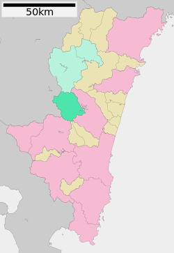
 Location of Nishimera in Miyazaki Prefecture | |
 Nishimera Location in Japan | |
| Coordinates: 32°14′2″N 131°9′24″E | |
| Country | Japan |
| Region | Kyushu |
| Prefecture | Miyazaki Prefecture |
| District | Koyu |
| Area | |
| • Total | 271.51 km2 (104.83 sq mi) |
| Population (October 1, 2019) | |
| • Total | 1,013 |
| • Density | 3.7/km2 (9.7/sq mi) |
| Time zone | UTC+09:00 (JST) |
| Climate | Cfa |
| Website | www |
As of 1 October 2019[update], the village has an estimated population of 1,013[1] and the density of 3.73 persons per km2. The total area is 271.51 km2.
Nishimera is made up of the hamlets of Murasho, Ogawa, Koshino, Yokono, Takehara, Kanmera, and Itaya.
The main hamlet of Nishimera is called Murasho, has a population of 639 and has one traffic light. However such isolation is balanced by the mountains which surround the village and the river which runs through it.[original research?]
Geography
Climate
Nishimera has a humid subtropical climate (Köppen climate classification Cfa) with hot, humid summers and cool winters. The average annual temperature in Nishimera is 15.4 °C (59.7 °F). The average annual rainfall is 3,035.9 mm (119.52 in) with June as the wettest month. The temperatures are highest on average in August, at around 25.6 °C (78.1 °F), and lowest in January, at around 4.9 °C (40.8 °F).[2] The highest temperature ever recorded in Nishimera was 39.7 °C (103.5 °F) on 17 August 2020; the coldest temperature ever recorded was −8.2 °C (17.2 °F) on 15 January 1985.[3]
| Climate data for Nishimera (1991−2020 normals, extremes 1979−present) | |||||||||||||
|---|---|---|---|---|---|---|---|---|---|---|---|---|---|
| Month | Jan | Feb | Mar | Apr | May | Jun | Jul | Aug | Sep | Oct | Nov | Dec | Year |
| Record high °C (°F) | 21.2 (70.2) |
24.2 (75.6) |
27.0 (80.6) |
31.5 (88.7) |
33.9 (93.0) |
35.1 (95.2) |
39.3 (102.7) |
39.7 (103.5) |
36.4 (97.5) |
33.2 (91.8) |
27.3 (81.1) |
22.2 (72.0) |
39.7 (103.5) |
| Average high °C (°F) | 11.1 (52.0) |
12.9 (55.2) |
16.5 (61.7) |
21.4 (70.5) |
25.3 (77.5) |
26.5 (79.7) |
30.8 (87.4) |
31.5 (88.7) |
28.8 (83.8) |
24.2 (75.6) |
18.4 (65.1) |
13.0 (55.4) |
21.7 (71.1) |
| Daily mean °C (°F) | 4.9 (40.8) |
6.4 (43.5) |
9.8 (49.6) |
14.4 (57.9) |
18.5 (65.3) |
21.4 (70.5) |
25.1 (77.2) |
25.6 (78.1) |
22.8 (73.0) |
17.6 (63.7) |
11.9 (53.4) |
6.6 (43.9) |
15.4 (59.7) |
| Average low °C (°F) | 0.2 (32.4) |
1.3 (34.3) |
4.5 (40.1) |
8.8 (47.8) |
13.3 (55.9) |
17.8 (64.0) |
21.4 (70.5) |
21.9 (71.4) |
18.9 (66.0) |
13.0 (55.4) |
7.2 (45.0) |
1.9 (35.4) |
10.9 (51.5) |
| Record low °C (°F) | −8.2 (17.2) |
−7.8 (18.0) |
−5.5 (22.1) |
−2.2 (28.0) |
3.6 (38.5) |
8.0 (46.4) |
13.3 (55.9) |
14.8 (58.6) |
7.5 (45.5) |
1.6 (34.9) |
−3.7 (25.3) |
−6.9 (19.6) |
−8.2 (17.2) |
| Average precipitation mm (inches) | 75.0 (2.95) |
116.3 (4.58) |
167.0 (6.57) |
172.9 (6.81) |
232.3 (9.15) |
581.7 (22.90) |
545.3 (21.47) |
393.5 (15.49) |
414.8 (16.33) |
166.1 (6.54) |
91.9 (3.62) |
79.3 (3.12) |
3,035.9 (119.52) |
| Average precipitation days (≥ 1.0 mm) | 7.4 | 8.6 | 12.2 | 11.2 | 11.1 | 17.3 | 15.5 | 14.9 | 12.7 | 8.2 | 8.2 | 7.0 | 134.3 |
| Mean monthly sunshine hours | 161.4 | 144.4 | 163.4 | 174.0 | 168.8 | 105.9 | 146.7 | 157.1 | 129.6 | 163.3 | 148.4 | 161.3 | 1,824.1 |
| Source: Japan Meteorological Agency[3][2] | |||||||||||||
Demographics
Per Japanese census data, the population of Nishimera in 2020 is 1,000 people.[4] Nishimera has been conducting censuses since 1920.
|
|
| ||||||||||||||||||||||||||||||||||||||||||||||||||||||||||||||||||||||||
| Nishimera population statistics[4] | ||||||||||||||||||||||||||||||||||||||||||||||||||||||||||||||||||||||||||
Twin towns – sister cities
Nishimera is twinned with:
 Kikuchi, Kumamoto, Japan
 Tōno, Iwate, Japan
Transportation
Highways
- Higashikyushu Expressway
- Kyushu Expressway
- Japan National Route 219
- Japan National Route 265
References
- "Population of Nishimera Village" (in Japanese). Japan: Nishimera Village. Retrieved 28 April 2017.[permanent dead link]
- 気象庁 / 平年値(年・月ごとの値). JMA. Retrieved April 22, 2022.
- 観測史上1~10位の値(年間を通じての値). JMA. Retrieved April 22, 2022.
- Nishimera population statistics
External links
 Media related to Nishimera, Miyazaki at Wikimedia Commons
- Nishimera official website (in Japanese)
 Geographic data related to Nishimera, Miyazaki at OpenStreetMap
На других языках
- [en] Nishimera, Miyazaki
[ru] Нисимера
Нисимера (яп. 西米良村 Нисимэра-сон) — село в Японии, находящееся в уезде Кою префектуры Миядзаки. Площадь села составляет 271,56 км²[1], население — 1184 человека (1 августа 2014)[2], плотность населения — 4,36 чел./км².Другой контент может иметь иную лицензию. Перед использованием материалов сайта WikiSort.org внимательно изучите правила лицензирования конкретных элементов наполнения сайта.
WikiSort.org - проект по пересортировке и дополнению контента Википедии

