world.wikisort.org - Japan
Murata (村田町, Murata-machi) is a town located in Miyagi Prefecture, Japan. As of 31 May 2020[update], the town had an estimated population of 10,675, and a population density of 140 persons per km2 in 4026 households.[1] The total area of the town is 78.38 square kilometres (30.26 sq mi). In September 2014, the 7.4 hectare old centre of town was protected as an Important Preservation District by the national government for its traditional merchant quarter architecture.[2]
Murata
村田町 | |
|---|---|
Town | |
 Murata Town Office | |
 Flag  Seal | |
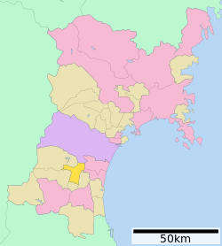 Location of Murata in Miyagi Prefecture | |
 Murata | |
| Coordinates: 38°07′6.7″N 140°43′20.7″E | |
| Country | Japan |
| Region | Tōhoku |
| Prefecture | Miyagi |
| District | Shibata |
| Area | |
| • Total | 78.38 km2 (30.26 sq mi) |
| Population (May 31, 2020) | |
| • Total | 10,675 |
| • Density | 140/km2 (350/sq mi) |
| Time zone | UTC+9 (Japan Standard Time) |
| City symbols | |
| • Tree | Pine |
| • Flower | Osmanthus fragrans |
| • Bird | Green pheasant |
| Phone number | 0224-83-2111 |
| Address | Murata-machi, Shibata-gun, Miyagi-ken 989-1392 |
| Website | Official website |

Geography
Murata is located in south-central Miyagi Prefecture in the Tōhoku region of northern Japan. The Shiroishi River runs through the town.
Neighboring municipalities
Miyagi Prefecture
Climate
Murata has a humid climate (Köppen climate classification Cfa) characterized by mild summers and cold winters. The average annual temperature in Murata is 12.5 °C. The average annual rainfall is 1271 mm with September as the wettest month. The temperatures are highest on average in August, at around 25.0 °C, and lowest in January, at around 1.5 °C.[3]
Demographics
Per Japanese census data,[4] the population of Murata declined over the past 30 years.
| Year | Pop. | ±% |
|---|---|---|
| 1950 | 16,049 | — |
| 1960 | 15,015 | −6.4% |
| 1970 | 13,337 | −11.2% |
| 1980 | 13,370 | +0.2% |
| 1990 | 13,632 | +2.0% |
| 2000 | 13,166 | −3.4% |
| 2010 | 11,995 | −8.9% |
| 2020 | 10,666 | −11.1% |
History
The area of present-day Murata was part of ancient Mutsu Province, and was part of the holdings of Sendai Domain under the Edo period Tokugawa shogunate. The modern village of Murata was established on April 1, 1889 with the establishment of post-Meiji restoration modern municipalities system. It was promoted to town status on October 31, 1895. The town merged with the neighboring towns on Tomioka and Numabe on April 20, 1955.
Government
Murata has a mayor-council form of government with a directly elected mayor and a unicameral town council of 12 members. Murata, collectively with the other municipalities in Shibata District contributes two seats to the Miyagi Prefectural legislature. In terms of national politics, the town is part of Miyagi 3rd district of the lower house of the Diet of Japan.
Economy
The economy of Murata is largely based on agriculture, and the town is especially known for its production of fava beans.
Education
Murata has two public elementary schools and two public middle schools operated by the town government, and one public high school operated by the Miyagi Prefectural Board of Education.
Transportation
Railway
- Murata does not have any passenger train service.
Highway
 Tōhoku Expressway – Murata Interchange – Murata Junction
 Yamagata Expressway – Murata Junction
 National Route 4
Sister city relations
Local attractions
- Sportsland SUGO
References
- Murata official statistics (in Japanese)
- 村田町村田伝統的建造物群保存地区 [Murata Groups of Traditional Buildings] (in Japanese). Murata town. Retrieved 2015-09-22.
- Murata climate data
- Murata population statistics
- "International Exchange". List of Affiliation Partners within Prefectures. Council of Local Authorities for International Relations (CLAIR). Archived from the original on 22 December 2015. Retrieved 21 November 2015.
External links
![]() Media related to Murata, Miyagi at Wikimedia Commons
Media related to Murata, Miyagi at Wikimedia Commons
- Official Website (in Japanese)
Sendai (capital) | |||
| Sendai |
| ||
| Cities | |||
| Districts |
| ||
List of mergers in Miyagi Prefecture | |||
На других языках
- [en] Murata, Miyagi
[es] Murata (Miyagi)
Murata (村田町, Murata-machi?) es un pueblo localizado en la prefectura de Miyagi, Japón. Tiene una población estimada, a fines de enero de 2022, de 10 395 habitantes.[3][ru] Мурата
Мурата (яп. 村田町 Мурата-мати) — посёлок в Японии, находящийся в уезде Сибата префектуры Мияги. Площадь посёлка составляет 78,41 км²[1], население — 11 673 человека (31 июля 2014)[2], плотность населения — 148,87 чел./км².Другой контент может иметь иную лицензию. Перед использованием материалов сайта WikiSort.org внимательно изучите правила лицензирования конкретных элементов наполнения сайта.
WikiSort.org - проект по пересортировке и дополнению контента Википедии