world.wikisort.org - Japan
Miyakonojō (都城市, Miyakonojō-shi) is a city in Miyazaki Prefecture, Japan. The city was founded on April 1, 1924. As of June 1, 2019, the city has an estimated population of 161,137, with 70,549 households and a population density of 247 per km2. The total area is 653.36 km2 making it the largest city in the prefecture in terms of area.
Miyakonojō
都城市 | |
|---|---|
City | |
 View of downtown Miyakonojo, from Miyakonojo Castle Ruin Park | |
 Flag  Emblem | |
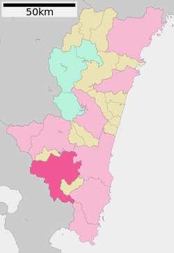
 Location of Miyakonojō in Miyazaki Prefecture | |
 | |
 Miyakonojō Location in Japan | |
| Coordinates: 31°43′N 131°4′E | |
| Country | Japan |
| Region | Kyushu |
| Prefecture | Miyazaki Prefecture |
| Government | |
| • Mayor | Makoto Nagamine |
| Area | |
| • Total | 653.36 km2 (252.26 sq mi) |
| Population (June 1, 2019) | |
| • Total | 161,137 |
| • Density | 250/km2 (640/sq mi) |
| Time zone | UTC+09:00 (JST) |
| City hall address | 6-21 Himegichō, Miyakonojō-shi, Miyazaki-ken 885-8555 |
| Climate | Cfa |
| Website | www |
| Symbols | |
| Flower | Iris |
| Tree | Japanese zelkova |
History
Miyakonojō is known as the birthplace of the Shimazu Estate, the largest shōen (estate or manor) of medieval Japan. In the 1020s, a powerful official named Taira no Suemoto developed a small manor named Shimazu-in. Expanded substantially in the first half of the 12th century, it eventually covered large portions of Satsuma, Ōsumi and Hyūga Provinces. In 1185, Koremune no Tadahisa was appointed as jitō of the Shimazu Estate and thereafter claimed the clan name of Shimazu. It is said that one of Tadahisa's residences, called Iwayoshi Gosho, was located at Miyakonojō. Between the Muromachi period and Edo period, the Hōngō family, which was a branch family of the Shimazus, controlled the area. After the Boshin War, it became one of the cities to abolish the han system. In 1871, it became a prefecture for a year. On January 1, 2006, the towns of Takajō, Takazaki, Yamada and Yamanokuchi (all from Kitamorokata District) were merged into Miyakonojō.
Geography
Climate
Miyakonojō has a humid subtropical climate (Köppen climate classification Cfa), but is cooler than other cities in Miyazaki. The average temperature is 16.8 °C (62.2 °F), and it rains less than in Miyazaki City. The area's climate is influenced by its proximity to mountains.
| Climate data for Miyakonojō (1991−2020 normals, extremes 1942−present) | |||||||||||||
|---|---|---|---|---|---|---|---|---|---|---|---|---|---|
| Month | Jan | Feb | Mar | Apr | May | Jun | Jul | Aug | Sep | Oct | Nov | Dec | Year |
| Record high °C (°F) | 24.3 (75.7) |
23.5 (74.3) |
27.1 (80.8) |
30.4 (86.7) |
34.0 (93.2) |
34.4 (93.9) |
37.1 (98.8) |
39.4 (102.9) |
35.2 (95.4) |
34.0 (93.2) |
28.0 (82.4) |
24.4 (75.9) |
39.4 (102.9) |
| Average high °C (°F) | 12.1 (53.8) |
13.7 (56.7) |
16.9 (62.4) |
21.6 (70.9) |
25.5 (77.9) |
27.1 (80.8) |
31.4 (88.5) |
32.1 (89.8) |
29.3 (84.7) |
24.8 (76.6) |
19.5 (67.1) |
14.2 (57.6) |
22.4 (72.2) |
| Daily mean °C (°F) | 6.1 (43.0) |
7.7 (45.9) |
11.0 (51.8) |
15.6 (60.1) |
19.8 (67.6) |
22.7 (72.9) |
26.7 (80.1) |
27.0 (80.6) |
24.2 (75.6) |
19.1 (66.4) |
13.5 (56.3) |
8.1 (46.6) |
16.8 (62.2) |
| Average low °C (°F) | 0.9 (33.6) |
2.3 (36.1) |
5.7 (42.3) |
10.2 (50.4) |
14.9 (58.8) |
19.3 (66.7) |
23.2 (73.8) |
23.4 (74.1) |
20.4 (68.7) |
14.4 (57.9) |
8.4 (47.1) |
2.8 (37.0) |
12.2 (53.9) |
| Record low °C (°F) | −9.8 (14.4) |
−8.5 (16.7) |
−5.9 (21.4) |
−2.7 (27.1) |
2.3 (36.1) |
9.1 (48.4) |
15.0 (59.0) |
14.4 (57.9) |
6.3 (43.3) |
−0.8 (30.6) |
−4.8 (23.4) |
−7.8 (18.0) |
−9.8 (14.4) |
| Average precipitation mm (inches) | 66.1 (2.60) |
106.2 (4.18) |
163.3 (6.43) |
184.3 (7.26) |
207.8 (8.18) |
559.7 (22.04) |
447.0 (17.60) |
320.9 (12.63) |
314.2 (12.37) |
131.6 (5.18) |
94.0 (3.70) |
74.6 (2.94) |
2,694.2 (106.07) |
| Average precipitation days (≥ 1.0 mm) | 6.6 | 8.1 | 11.5 | 10.1 | 9.9 | 16.4 | 13.2 | 12.7 | 12.5 | 7.6 | 7.5 | 5.9 | 122 |
| Average relative humidity (%) | 71 | 70 | 70 | 70 | 73 | 82 | 80 | 79 | 79 | 75 | 76 | 73 | 75 |
| Mean monthly sunshine hours | 167.2 | 155.2 | 169.4 | 173.9 | 169.2 | 103.1 | 168.2 | 183.6 | 149.1 | 172.4 | 158.5 | 164.8 | 1,934.5 |
| Source: Japan Meteorological Agency[1][2] | |||||||||||||
Neighboring municipalities
Miyazaki Prefecture
Demographics
Per Japanese census data, the population of Miyakonojō in 2020 is 160,640 people.[3] Miyakonojō has been conducting censuses since 1920.
|
|
| ||||||||||||||||||||||||||||||||||||||||||||||||||||||||||||||||||||||||
| Miyakonojō population statistics[3] | ||||||||||||||||||||||||||||||||||||||||||||||||||||||||||||||||||||||||||
Industry
Many of Miyakonojō's citizens work as farmers. They produce gobō, meat, and bell peppers. Miyakonojō is also home to some agriculture-related manufacturing.
Miyakonojō is also famous for producing traditional Japanese archery bows from the abundant bamboo in the area.[4]

Education
Schools
Miyakonojō has 35 elementary schools and 19 junior high schools.
Notable residents
- Tomoji Tanabe, the world's oldest man 1895–2009, was born and lived in Miyakonojō.[5]
- Kōsei Inoue, Olympic Gold Medalist in Judo.
- Gōgen Yamaguchi, known as "The Cat", was a renowned martial arts master of the Gōjū-ryū style of Karate.
- Jūzō Yamasaki, the manga artist was born in Miyakonojō.
- Hideo Higashikokubaru, a famous comedian and the former Governor of Miyazaki.
- Yuya Yanagi, a professional baseball player for the Chunichi Dragons.
- Masatoshi Nagase, actor.
Current issues
Miyakonojō is experiencing a declining population. Several other cities in Miyazaki Prefecture are also facing this problem. Many schools are scheduled to close due to the declining population, which has resulted in fewer children.
References
- 気象庁 / 平年値(年・月ごとの値). JMA. Retrieved May 17, 2022.
- 観測史上1~10位の値(年間を通じての値). JMA. Retrieved May 17, 2022.
- Miyakonojō population statistics
- Miyakonojo daikyu (archery bows), Japan National Tourist Organization.
- Oldest man marks 112th birthday, BBC News, 18 September 2007.
External links
| Wikimedia Commons has media related to Miyakonojo, Miyazaki. |
- Miyakonojō City official website (in Japanese)
 Miyakonojo travel guide from Wikivoyage
 Geographic data related to Miyakonojō at OpenStreetMap
Miyazaki (capital) | |
| Core city | |
| Cities | |
| Districts | |
List of mergers in Miyazaki Prefecture | |
Authority control | |
|---|---|
| General | |
| National libraries | |
| Scientific databases | |
| Other |
|
На других языках
[de] Miyakonojō
Miyakonojō (japanisch 都城市, -shi) ist eine japanische Stadt in der Präfektur Miyazaki auf der südjapanischen Insel Kyūshū.- [en] Miyakonojō
[es] Miyakonojō (Miyazaki)
Miyakonojō (都城市, Miyakonojō-shi?) es una ciudad localizada en la prefectura de Miyazaki, Japón.[ru] Мияконодзё
Мия́конодзё[1] (яп. 都城市 Мияконодзё:-си) — город в Японии, находящийся в префектуре Миядзаки. Площадь города составляет 653,31 км²[2], население — 166 427 человек (1 августа 2014)[3], плотность населения — 254,74 чел./км².Другой контент может иметь иную лицензию. Перед использованием материалов сайта WikiSort.org внимательно изучите правила лицензирования конкретных элементов наполнения сайта.
WikiSort.org - проект по пересортировке и дополнению контента Википедии