world.wikisort.org - Japan
Karumai (軽米町, Karumai-machi) is a town located in Iwate Prefecture, Japan. As of 31 March 2020[update], the town had an estimated population of 8,895 in 3769 households,[1] and a population density of 36 persons per km². The total area of the town is 245.82 square kilometres (94.91 sq mi).
Karumai
軽米町 | |
|---|---|
Town | |
Karumai Town Hall Park in Karumai | |
 Flag  Emblem | |
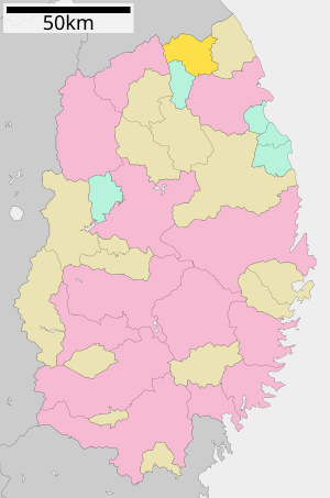 Location of Karumai in Iwate Prefecture | |
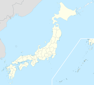 Karumai Location of Karumai in Japan | |
| Coordinates: 40°19′36.3″N 141°27′37.7″E | |
| Country | Japan |
| Region | Tōhoku |
| Prefecture | Iwate |
| District | Kunohe |
| Area | |
| • Total | 245.82 km2 (94.91 sq mi) |
| Population (March 1, 2020) | |
| • Total | 8,895 |
| • Density | 36/km2 (94/sq mi) |
| Time zone | UTC+9 (Japan Standard Time) |
| Phone number | 0195-46-2111 |
| Address | Karumai dai-10 jiwari 85, Karumai-machi, Kunohe-gun, Iwate 028-6302 |
| Climate | Dfa |
| Website | Official website |
| Symbols | |
| Bird | Copper pheasant |
| Flower | Kobushi |
| Tree | Japanese Yew |


Geography
Karumai is located in far northcentral Iwate Prefecture, bordered by Aomori Prefecture to the north.
Neighboring municipalities
Aomori Prefecture
- Hachinohe
- Nanbu
- Hashikami
Iwate Prefecture
Climate
Karumai has a humid oceanic climate (Köppen climate classification Cfa) characterized by mild summers and cold winters. The average annual temperature in Karumai is 9.5 °C. The average annual rainfall is 1209 mm with September as the wettest month and February as the driest month. The temperatures are highest on average in August, at around 22.5 °C, and lowest in January, at around -2.4 °C.[2]
| Climate data for Karumai (1991−2020 normals, extremes 1976−present) | |||||||||||||
|---|---|---|---|---|---|---|---|---|---|---|---|---|---|
| Month | Jan | Feb | Mar | Apr | May | Jun | Jul | Aug | Sep | Oct | Nov | Dec | Year |
| Record high °C (°F) | 14.2 (57.6) |
17.2 (63.0) |
21.1 (70.0) |
29.1 (84.4) |
33.0 (91.4) |
33.8 (92.8) |
34.6 (94.3) |
36.2 (97.2) |
33.9 (93.0) |
28.3 (82.9) |
23.4 (74.1) |
18.4 (65.1) |
36.2 (97.2) |
| Average high °C (°F) | 1.4 (34.5) |
2.4 (36.3) |
6.6 (43.9) |
13.7 (56.7) |
19.6 (67.3) |
22.6 (72.7) |
25.8 (78.4) |
27.0 (80.6) |
23.3 (73.9) |
17.4 (63.3) |
11.0 (51.8) |
4.2 (39.6) |
14.6 (58.2) |
| Daily mean °C (°F) | −2.6 (27.3) |
−2.0 (28.4) |
1.6 (34.9) |
7.7 (45.9) |
13.4 (56.1) |
17.0 (62.6) |
20.9 (69.6) |
22.0 (71.6) |
18.0 (64.4) |
11.5 (52.7) |
5.5 (41.9) |
0.0 (32.0) |
9.4 (48.9) |
| Average low °C (°F) | −7.5 (18.5) |
−7.3 (18.9) |
−3.6 (25.5) |
1.5 (34.7) |
7.1 (44.8) |
11.8 (53.2) |
16.8 (62.2) |
17.8 (64.0) |
13.2 (55.8) |
5.7 (42.3) |
0.1 (32.2) |
−4.5 (23.9) |
4.3 (39.7) |
| Record low °C (°F) | −21.7 (−7.1) |
−23.0 (−9.4) |
−18.8 (−1.8) |
−10.0 (14.0) |
−2.8 (27.0) |
0.1 (32.2) |
6.3 (43.3) |
6.4 (43.5) |
1.1 (34.0) |
−4.4 (24.1) |
−10.5 (13.1) |
−18.6 (−1.5) |
−23.0 (−9.4) |
| Average precipitation mm (inches) | 40.1 (1.58) |
38.1 (1.50) |
54.5 (2.15) |
57.9 (2.28) |
80.5 (3.17) |
93.3 (3.67) |
150.2 (5.91) |
162.6 (6.40) |
151.0 (5.94) |
113.0 (4.45) |
60.4 (2.38) |
56.3 (2.22) |
1,050.9 (41.37) |
| Average precipitation days (≥ 1.0 mm) | 8.1 | 7.3 | 8.8 | 9.6 | 10.1 | 9.2 | 11.5 | 11.7 | 11.4 | 9.7 | 10.1 | 8.5 | 116 |
| Mean monthly sunshine hours | 113.5 | 112.2 | 156.0 | 178.7 | 196.6 | 163.3 | 136.6 | 156.1 | 142.9 | 148.9 | 125.5 | 109.6 | 1,752.1 |
| Source: JMA[3][4] | |||||||||||||
Demographics
Per Japanese census data,[5] the population of Karumai peaked at around the year 1960 and has steadily declined over the past 60 years.
| Year | Pop. | ±% |
|---|---|---|
| 1920 | 12,147 | — |
| 1930 | 13,561 | +11.6% |
| 1940 | 14,716 | +8.5% |
| 1950 | 16,842 | +14.4% |
| 1960 | 17,672 | +4.9% |
| 1970 | 15,462 | −12.5% |
| 1980 | 13,768 | −11.0% |
| 1990 | 12,646 | −8.1% |
| 2000 | 11,863 | −6.2% |
| 2010 | 10,212 | −13.9% |
| 2020 | 8,895 | −12.9% |
History
The area of present-day Karumai was part of ancient Mutsu Province, dominated by the Nambu clan from the Muromachi period, and part of Hachinohe Domain under the Edo period Tokugawa shogunate. During the early Meiji period, the village of Karumai within Kitakunohe District, Iwate Prefecture was created on April 1, 1889, with the establishment of the modern municipalities system. Kita-Kunohe District and Minami-Kunohe Districts merged to form Kunohe District on April 1, 1897. The village was raised to town status on January 1, 1925. The neighboring villages of Kogarumai and Hareyama were merged with Karumai on January 1, 1955.
Government
Karumai has a mayor-council form of government with a directly elected mayor and a unicameral town council of 12 members. Karumai, as part of Kunohe District, contributes two seats to the Iwate Prefectural legislature. In terms of national politics, the town is part of Iwate 2nd district of the lower house of the Diet of Japan.
Economy
The economy of Karumai is based on agriculture, particularly the various grains, including millet, livestock raising, and the production of charcoal. The hardy kiwi is a noted local specialty.[6]
Education
Karumai has three public elementary schools and one public middle school operated by the town government, and one public high school operated by the Iwate Prefectural Board of Education.
Transportation
Railway
- Karumai does not have any passenger train service.
Highway
 Hachinohe Expressway – Orizume Service Area - Karumai Interchange
 National Route 340
 National Route 395
Noted people from Karumai
- Haruichi Furudate, manga artist (Haikyu!!, Yotsuya Senpai no Kaidan). Much of Haikyu!! is based on actual locations in Karumai.
References
- Kurumai Town official statistics
- Karumai climate data
- 観測史上1~10位の値(年間を通じての値). JMA. Retrieved February 25, 2022.
- 気象庁 / 平年値(年・月ごとの値). JMA. Retrieved February 25, 2022.
- Karumai population statistics
- Karumai official home page
External links
![]() Media related to Karumai, Iwate at Wikimedia Commons
Media related to Karumai, Iwate at Wikimedia Commons
- Official Website (in Japanese)
Morioka (capital) | ||
| Core city | ||
| Cities | ||
| Districts |
| |
List of mergers in Iwate Prefecture | ||
На других языках
- [en] Karumai, Iwate
[ru] Курумай
Курумай (яп. 軽米町 Карумай-мати) — посёлок в Японии, находящийся в уезде Кунохе префектуры Иватэ. Площадь посёлка составляет 245,74 км²[1], население — 9507 человек (1 августа 2014)[2], плотность населения — 38,69 чел./км².Другой контент может иметь иную лицензию. Перед использованием материалов сайта WikiSort.org внимательно изучите правила лицензирования конкретных элементов наполнения сайта.
WikiSort.org - проект по пересортировке и дополнению контента Википедии