world.wikisort.org - Italy
Valtournenche (local Valdôtain: Vótornéntse) is a town and comune in the Aosta Valley region of north-western Italy, 1,500 m (4,900 ft) above the sea level. It is named after and covers most of the Valtournenche, a valley on the left side of the Dora Baltea, from Châtillon to the Matterhorn. Valtournenche is close to Cervinia and in winter the two towns are connected also with the ski slopes. In fact, they are part of the same ski resort with also Zermatt, Switzerland.[3]
This article needs additional citations for verification. (December 2009) |
Valtournenche
Vótornéntse | |
|---|---|
Comune | |
| Comune di Valtournenche Commune de Valtournenche | |
 | |
 Coat of arms | |
Location of Valtournenche  | |
 Valtournenche Location of Valtournenche in Italy  Valtournenche Valtournenche (Aosta Valley) | |
| Coordinates: 45°53′N 07°37′E | |
| Country | Italy |
| Region | Aosta Valley |
| Province | none |
| Frazioni | Barmasse, Bioley, Brengaz, Breuil-Cervinia, Busserailles, Chaloz, Châtelard, Champ l'éve, Cheneil, Cheperon, Tsignanaz (Cignana), Clou, Cré, Cré-du-Pont, Crépin, Crétaz, Duerche, Euillaz, Fontaine, La Muranche, La Vénaz, Layet, Laviel, Le Lou (Loz), Losanche, Maën, Maisonnasse, Montaz, Moulin, Mont-Mené, Mont-Perron, Pâquier (chef-lieu), Pecou, Les Perrères, Pessey, Promindoz, Saix, Servaz, Singlin, Tourtourouse, Ussin, Valmartin |
| Area | |
| • Total | 115 km2 (44 sq mi) |
| Elevation | 1,528 m (5,013 ft) |
| Population (December 31, 2004)[2] | |
| • Total | 2,163 |
| • Density | 19/km2 (49/sq mi) |
| Demonym(s) | Valtournains |
| Time zone | UTC+1 (CET) |
| • Summer (DST) | UTC+2 (CEST) |
| Postal code | 11028 |
| Dialing code | 0166 |
| Website | http://www.comune.valtournenche.ao.it |
History
This section is empty. You can help by adding to it. (March 2020) |
Notable people
- Jean-Antoine Carrel (1829–1890), mountain climber
- Jean-Joseph Maquignaz (1829–1890), mountain climber
- Georges Carrel (1800–1870), canon, mountain climber and botanist
- Luigi Carrel (1901–1983), mountain climber
- Piero Maquignaz, skier and mountain climber
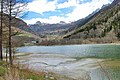 The Maën lake
 Maën lake seen from Pâquier


References
- "Superficie di Comuni Province e Regioni italiane al 9 ottobre 2011". Italian National Institute of Statistics. Retrieved 16 March 2019.
- "Popolazione Residente al 1° Gennaio 2018". Italian National Institute of Statistics. Retrieved 16 March 2019.
- "Valtournenche". Cervinia Ski Paradise. Cervinia. Retrieved 11 October 2018.
Comuni of Aosta Valley | ||
|---|---|---|
|  | |
This article on a location in Aosta Valley is a stub. You can help Wikipedia by expanding it. |
На других языках
- [en] Valtournenche
[es] Valtournenche
Valtournenche (durante el fascismo, de 1939 a 1946, Valtornenza) es una localidad y comune italiana de la región del Valle de Aosta, con 2.211 habitantes.[2][ru] Вальтурнанш
Вальтурнанш (фр. Valtournenche) — коммуна в Италии, располагается в автономном регионе Валле-д’Аоста.Текст в блоке "Читать" взят с сайта "Википедия" и доступен по лицензии Creative Commons Attribution-ShareAlike; в отдельных случаях могут действовать дополнительные условия.
Другой контент может иметь иную лицензию. Перед использованием материалов сайта WikiSort.org внимательно изучите правила лицензирования конкретных элементов наполнения сайта.
Другой контент может иметь иную лицензию. Перед использованием материалов сайта WikiSort.org внимательно изучите правила лицензирования конкретных элементов наполнения сайта.
2019-2026
WikiSort.org - проект по пересортировке и дополнению контента Википедии
WikiSort.org - проект по пересортировке и дополнению контента Википедии