world.wikisort.org - Italy
San Fior is a comune (municipality) in the Province of Treviso in the Italian region Veneto, located about 50 kilometres (31 mi) north of Venice and about 30 kilometres (19 mi) northeast of Treviso. As of 31 December 2004, it had a population of 6,357 and an area of 17.8 square kilometres (6.9 sq mi).[3]
San Fior | |
|---|---|
Comune | |
| Comune di San Fior | |
 Church in San Fior | |
Location of San Fior  | |
 San Fior Location of San Fior in Italy  San Fior San Fior (Veneto) | |
| Coordinates: 45°54′N 12°23′E | |
| Country | Italy |
| Region | Veneto |
| Province | Province of Treviso (TV) |
| Area | |
| • Total | 17.8 km2 (6.9 sq mi) |
| Population (Dec. 2004)[2] | |
| • Total | 6,357 |
| • Density | 360/km2 (920/sq mi) |
| Demonym(s) | Sanfioresi |
| Time zone | UTC+1 (CET) |
| • Summer (DST) | UTC+2 (CEST) |
| Postal code | 31020 |
| Dialing code | 0438 |
San Fior borders the following municipalities: Codogné, Colle Umberto, Conegliano, Godega di Sant'Urbano, San Vendemiano.
Frazioni
San Fior is divided into three villages: the principal town is San Fior (or San Fior di Sopra); the south frazione is San Fior di Sotto and the north frazione is Castello Roganzuolo.
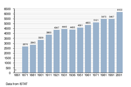
Demographic evolution
Twin towns
San Fior is twinned with:
 Colayrac-Saint-Cirq, France
References
- "Superficie di Comuni Province e Regioni italiane al 9 ottobre 2011". Italian National Institute of Statistics. Retrieved 16 March 2019.
- "Popolazione Residente al 1° Gennaio 2018". Italian National Institute of Statistics. Retrieved 16 March 2019.
- All demographics and other statistics: Italian statistical institute Istat.
|
| Authority control |
|
|---|
This article on a location in Veneto is a stub. You can help Wikipedia by expanding it. |
На других языках
- [en] San Fior
[ru] Сан-Фьор
Сан-Фьор (итал. San Fior) — коммуна в Италии, располагается в провинции Тревизо области Венеция.Текст в блоке "Читать" взят с сайта "Википедия" и доступен по лицензии Creative Commons Attribution-ShareAlike; в отдельных случаях могут действовать дополнительные условия.
Другой контент может иметь иную лицензию. Перед использованием материалов сайта WikiSort.org внимательно изучите правила лицензирования конкретных элементов наполнения сайта.
Другой контент может иметь иную лицензию. Перед использованием материалов сайта WikiSort.org внимательно изучите правила лицензирования конкретных элементов наполнения сайта.
2019-2026
WikiSort.org - проект по пересортировке и дополнению контента Википедии
WikiSort.org - проект по пересортировке и дополнению контента Википедии