world.wikisort.org - Israel
Atlit (Hebrew: עַתְלִית), (Arabic: عتليت) is a coastal town located south of Haifa, Israel. The community is in the Hof HaCarmel Regional Council in the Haifa District of Israel.
Atlit
עַתְלִית عتليت | |
|---|---|
| Hebrew transcription(s) | |
| • unofficial | Atlith |
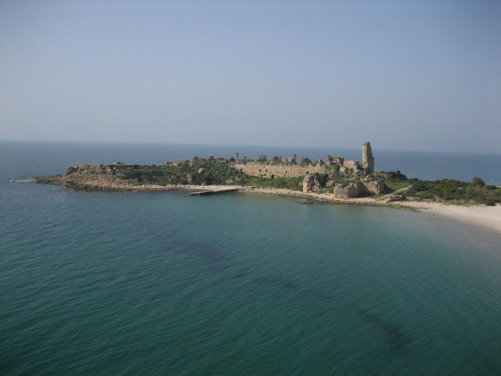 Atlit fortress | |
 Atlit  Atlit | |
| Coordinates: 32°41′14″N 34°56′18″E | |
| Grid position | formerly 144/234, now 144/232 PAL |
| Country | |
| District | Haifa |
| Council | Hof HaCarmel |
| Founded | 6900 BCE (Atlit Yam) 13th century(Oirat village) 19th century(Arab village)[1] 1903 (Jewish village settlement) 1948 (Israeli town) |
| Population (2022) | 10,639 |
Off the coast of Atlit is a submerged Neolithic village. Atlit was also a Crusader outpost, the Château Pèlerin, which fell to the Mamluks in 1291. During their rule, in the 14th century, it became home to a large concentration of Oirat Mongols. During early Ottoman rule, in the 16th century, it was recorded in tax registers as a port of call and a farm. Later, in the 19th century, it was a small Arab fishing village under the influence of the local al-Madi family.
An adjacent Jewish village was reestablished in 1903 under the auspices of Baron Edmond de Rothschild, which merged with the remnants of the Crusader fortress village. The Atlit detainee camp is nearby, which was used by the British to intern Jewish refugees and is now a museum.[2] From 1950 until the unification of the municipalities in 2003, Atlit was a local council whose jurisdiction was 14,000 dunams. In 2019 the population was 8,875.[3]
History
Neolithic
Atlit Yam is an ancient submerged Neolithic village off the coast of Atlit. Atlit-Yam provides the earliest known evidence for an agro-pastoral-marine subsistence system on the Levantine coast.[4]
Bronze Age
Atlit shows evidence of human habitation since the early Bronze Age.
Roman period
In the Bordeaux Itinerary, the town is known in Latin as Certa.[5]
Crusader period
The Crusaders built Château Pèlerin, one of the largest citadels in the Holy Land, and one of the last remaining Crusader outposts to withstand the assaults of Baibars (see also: Fall of Ruad).[citation needed] Atlit remained in Crusader's hands until 1291. The ruins of the citadel are still visible in modern times. Immediately to the north also lies a large medieval Christian cemetery hosting the graves of men, women and children who lived in the surrounding during the 13th century.[6][7]
Mamluk period
Atlit | |
|---|---|
Village | |
| Palestine grid | 144/233 |
| Geopolitical entity | Mandatory Palestine |
| Subdistrict | Haifa |
| Date of depopulation | Not known[8] |
In 1296, during the beginnings of Mamluk rule in the coastlands of Palestine, 10,000 to 18,000 Oirat Mongols entered the Mamluk realm as part of a defecting Ilkhanid troop, followed by smaller waves of arrivals. Although they originally established themselves in Cairo, most were eventually relocated to Atlit and northwestern Syria by the Mamluks.[9]
Ottoman period

The iskele (port of call or wharf) of Atlit, along with those of nearby Tantura and Tirat Lawza generated annual revenues of 5,000 akces in 1538, during Ottoman rule (1517–1917).[10] In 1596 Atlit was recorded as a farm that paid taxes to the government.[11]
In 1799, it appeared as the village Atlit on the map that Pierre Jacotin compiled that year.[12]
During the rule of Acre governor Sulayman Pasha al-Adil (1805–1819), Atlit was the headquarters of local strongman Mas'ud al-Madi, who was appointed the mutasallim (tax collector/enforcer) of the Atlit coast, which consisted of the territory that stretched from Umm Khalid to Haifa.[13][14] In 1859, the population was stated to be "180 souls", and their tillage 13 feddans, according to the English consul Rogers.[15]

An Ottoman village list of about 1870 showed that Atlit had 9 houses and a population of 33, though the population count included men only.[16][17] In 1881, the PEF's Survey of Western Palestine noted the existence of a small Arab village.[15] A population list from about 1887 showed that Atlit had about 180 inhabitants; all Muslims.[18]
In 1903, Jewish settlers built a nearby village which they also called Atlit;[19] The village was established by Edmond James de Rothschild, with most of the land bought from Arab fishermen.[20] A hundred families settled there but much of it was swampland, and many residents succumbed to malaria.[21] Aaron Aaronsohn established an agricultural station in Atlit in 1911, and during World War I the village was used as a base by the Nili organisation.[20]
British Mandate period
In the 1922 census of Palestine, during the British Mandate of Palestine period, Athlit had a population of 81; all Muslims, while Athlit Colony had a population of 78 Jews and 3 Muslims. Athlit Salt works had a population of 196 Jews, 1 Muslim and 1 Christian.[22] This had increased in the 1931 census to 413 Muslim, 496 Jews and 39 Christians; in a total of 193 houses.[23]
In 1938 there were 508 Arabs and 224 Jews.[citation needed] The Arab presence underwent a sharp decline in the 1940s due to land sales, so that by the 1945 statistics there were only 150 Arabs still living there (90 Muslims and 60 Christians) alongside 510 Jews.[24][25]
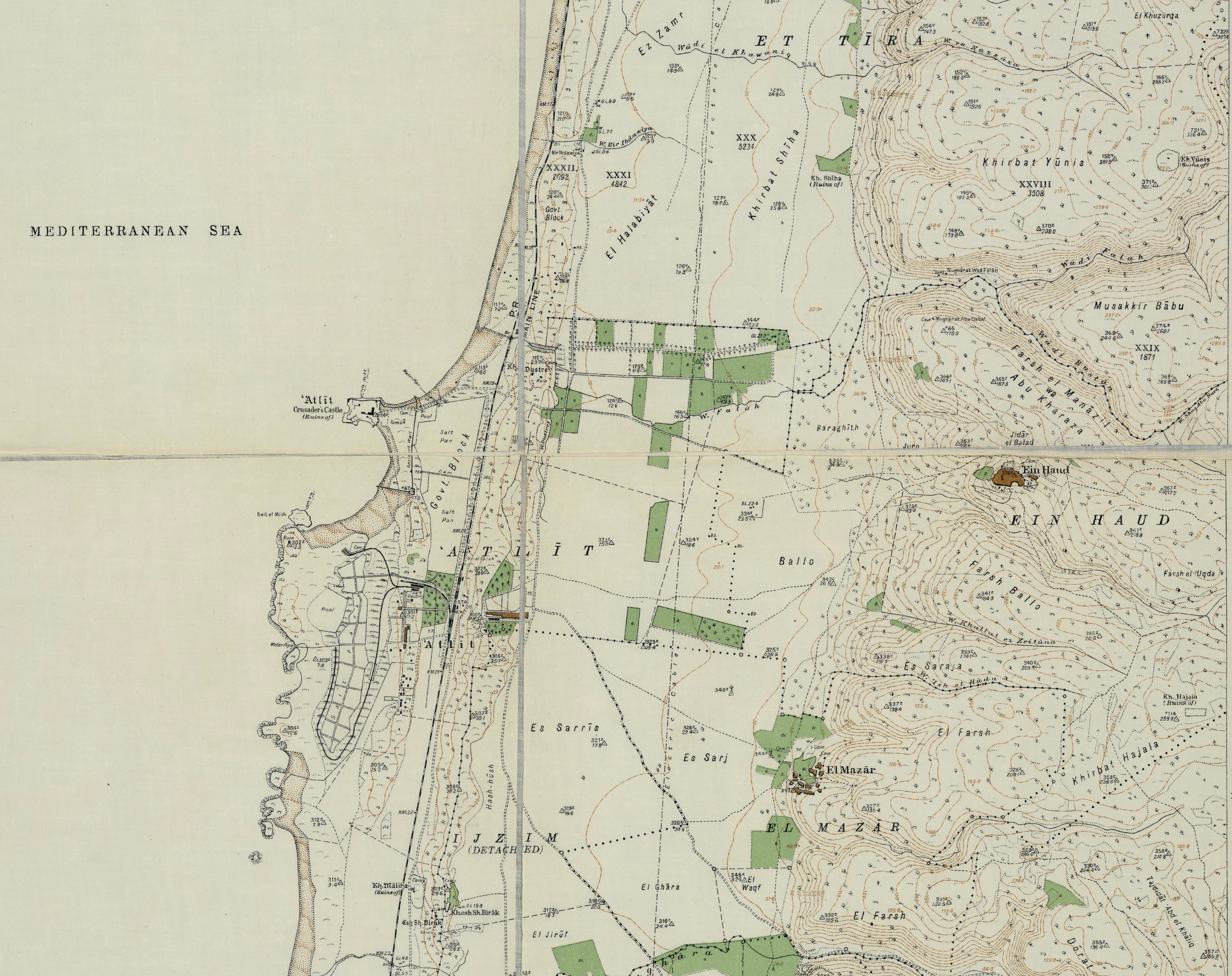
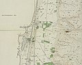 Atlit 1932 Survey of Palestine 1:20,000
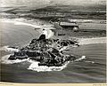 Atlit 1937
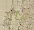 Atlit 1942 (including clearance camp) Survey of Palestine 1:20,000
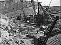 Atlit quarry 1934. Stone used in construction of Haifa harbour
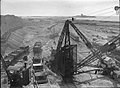 Atlit: Quarry with fortress in distance 1934
 Atlit 1945 Survey of Palestine 1:250,000
 Atlit: Moshe Sharett interned in camp 1947
 Atlit. Immigrant detention camp & quarry beyond broadcasting station


State of Israel
The circumstances under which the remaining Arabs left in 1948 are unknown.[8][26] The Atlit detainee camp was used by the British authorities to detain Jewish migrants to Palestine.[27]
It is now a museum of the Ha'apala (illegal Jewish immigration 1934–48). The headquarters of Shayetet 13 marine commandos is located at Atlit naval base on the Atlit promontory, placing the Crusader ruins there off-limits for regular visitors.
Atlit was declared a local council in 1950, but in 2004 was incorporated in the Hof HaCarmel Regional Council as one of a handful of Regional Committees. The late Knesset member Pesah Grupper lived in Atlit. He was head of its local council in the years 1959–1962 and 1969–1971.
Archaeology
In August 2021, marine archeologists headed by Yaakov Sharvit from Israel Antiquities Authority announced the discovery of 1,700-year-old coins weighing a total of 6 kg., dated back to the 4th century AD. According to Sharvit, coins demonstrated that they were assembled together and agglutinated because of oxidation of the metals.[28][29][30]
Neighborhoods
Neighborhoods in Atlit are Neve Moshe, Yamit, Giv'at HaPrahim, Giv'at HaBrekhot, Giv'at Sharon, Shoshanat HaYam, HaGoren, Yafe Nof, Argaman, Hofit, Savyonei Atlit and Allon. Atlit is in immediate vicinity of the villages Neve Yam and Ein Carmel.
Twin towns
 Nardò (Italy)
See also
- Atlit naval base
References
- "عتليت الأرض والذاكرة". 16 April 2018.
- "Pre-State Israel: Atlit Immigration Camp". Jewish Virtual Library. 2017. Retrieved May 17, 2017.
- "Population in the Localities 2019" (XLS). Israel Central Bureau of Statistics. Retrieved 16 August 2020.
- Marine archaeologyArchived June 6, 2011, at the Wayback Machine
- "Itinerary from Bordeaux to Jerusalem - 'The Bordeaux Pilgrim' (333 A.D.)", translated by Aubrey Stewart, pub. in: Palestine Pilgrim's Text Society, vol. 1, London 1887, p. 16 (note 8)
- Gleize, Yves; Vivas, Mathieu; Dorso, Simon; Castex, Dominique (3 April 2020). "Le cimetière d'Atlit, un espace des morts au pied de Château-Pèlerin (royaume latin de Jérusalem - xiiie siècle)". Les vivants et les morts dans les sociétés médiévales : XLVIIIe Congrès de la SHMESP (Jérusalem, 2017). Éditions de la Sorbonne. pp. 187–204. ISBN 979-10-351-0577-8.
- Gleize, Yves; Dorso, Simon (2019). "'Atlit, Crusader Cemetery". Hadashot Arkheologiyot. 131.
- Morris, 2004, p. xviii, village #387. Also gives "not known" as cause of depopulation
- Robinson 2020, p. 32, note 14.
- Abu-Husayn 1985, p. 197, note 122.
- Khalidi, 1992, p. 147
- Karmon, 1960, p. 163 Archived 2019-12-22 at the Wayback Machine
- Philipp, Thomas (2013). Acre: The Rise and Fall of a Palestinian City, 1730-1831. Columbia University Press. p. 88. ISBN 9780231506038.
- Yazbak, Mahmoud (1998). Haifa in the Late Ottoman Period, A Muslim Town in Transition, 1864–1914. Brill Academic Pub. p. 17. ISBN 9004110518.
- Conder and Kitchener, 1881, SWP I, p. 274
- Socin, 1879, p. 143
- Hartmann, 1883, p. 149
- Schumacher, 1888, p. 179
- Sandra M. Sufian (2008) Healing the Land and the Nation: Malaria and the Zionist Project in Palestine, 1920-1947, University of Chicago Press, p103
- Atlit Jewish Virtual Library
- The Claim of Disspossesion, Arieh Avneri
- Barron, 1923, Table XI, Sub-district of Haifa, p. 33
- Mills, 1932, p. 87
- Department of Statistics, 1945, p. 13
- Government of Palestine, Department of Statistics. Village Statistics, April, 1945. Quoted in Hadawi, 1970, p. 47
- Khalidi, 1992, pp. 146-147
- https://archive.today/20130103140834/http://www.hadassah.com/news/content/per_hadassah/archive/2003/03_FEB/traveler.htm. Archived from the original on January 3, 2013. Retrieved February 5, 2016.
{{cite web}}: Missing or empty|title=(help) - "Ancient 1,700-year-old coins found on Israeli beach". The Jerusalem Post | JPost.com. Retrieved 2021-08-27.
- Gershon, Livia. "Israeli Tour Guide on Camping Trip Discovers 1,700-Year-Old Coins". Smithsonian Magazine. Retrieved 2021-08-27.
- "1,700-Year-Old Coins Were Just Discovered Clumped Together on a Beach". Observer. 2021-08-19. Retrieved 2021-08-27.
Bibliography
- Abu-Husayn, Abdul-Rahim (1985). Provincial Leaderships in Syria, 1575–1650. Beirut: American University of Beirut. ISBN 9780815660729. OCLC 242675094.
- Barron, J. B., ed. (1923). Palestine: Report and General Abstracts of the Census of 1922. Government of Palestine.
- Conder, C.R.; Kitchener, H.H. (1881). The Survey of Western Palestine: Memoirs of the Topography, Orography, Hydrography, and Archaeology. Vol. 1. London: Committee of the Palestine Exploration Fund. p. 281
- Department of Statistics (1945). Village Statistics, April, 1945. Government of Palestine.
- Hartmann, M. (1883). "Die Ortschaftenliste des Liwa Jerusalem in dem türkischen Staatskalender für Syrien auf das Jahr 1288 der Flucht (1871)". Zeitschrift des Deutschen Palästina-Vereins. 6: 102–149.
- Hadawi, S. (1970). Village Statistics of 1945: A Classification of Land and Area ownership in Palestine. Palestine Liberation Organization Research Center. Archived from the original on 2018-12-08. Retrieved 2014-11-08.
- Irby, C.L.; Mangles, J. (1823). Travels in Egypt and Nubia, Syria, and Asia Minor; during the years 1817 & 1818. London: Printed for Private Distribution by T. White & Co. Irby and Mangles, 1823, p. 191
- Khalidi, W. (1992). All That Remains: The Palestinian Villages Occupied and Depopulated by Israel in 1948. Washington D.C.: Institute for Palestine Studies. ISBN 0-88728-224-5.
- Karmon, Y. (1960). "An Analysis of Jacotin's Map of Palestine" (PDF). Israel Exploration Journal. 10 (3, 4): 155–173, 244–253. Archived from the original (PDF) on 2019-12-22. Retrieved 2017-09-05.
- Mills, E., ed. (1932). Census of Palestine 1931. Population of Villages, Towns and Administrative Areas. Jerusalem: Government of Palestine.
- Morris, B. (2004). The Birth of the Palestinian Refugee Problem Revisited. Cambridge University Press. ISBN 978-0-521-00967-6.
- Palmer, E. H. (1881). The Survey of Western Palestine: Arabic and English Name Lists Collected During the Survey by Lieutenants Conder and Kitchener, R. E. Transliterated and Explained by E.H. Palmer. Committee of the Palestine Exploration Fund.
- Robinson, David M. (2020). In the Shadow of the Mongol Empire Ming China and Eurasia. Cambridge: Cambridge University Press. ISBN 978-1-108-48244-8.
- Schumacher, G. (1888). "Population list of the Liwa of Akka". Quarterly Statement - Palestine Exploration Fund. 20: 169–191.
- Socin, A. (1879). "Alphabetisches Verzeichniss von Ortschaften des Paschalik Jerusalem". Zeitschrift des Deutschen Palästina-Vereins. 2: 135–163.
External links
- Official Atlit Community Website
- Welcome To 'Atlit
- 'Atlit, from Zochrot
- Survey of Western Palestine, Map 5: IAA, Wikimedia commons
Palestinian Arab towns and villages depopulated during the 1948 Palestinian exodus by subdistrict | ||
|---|---|---|
| Acre Subdistrict |
| |
| Beisan Subdistrict |
| |
| Beersheba Subdistrict |
| |
| Gaza Subdistrict |
| |
| Haifa Subdistrict |
| |
| Hebron Subdistrict |
| |
| Jaffa Subdistrict |
| |
| Jenin Subdistrict |
| |
| Jerusalem Subdistrict |
| |
| Nazareth Subdistrict |
| |
| Ramle Subdistrict |
| |
| Safad Subdistrict |
| |
| Tiberias Subdistrict |
| |
| Tulkarm Subdistrict |
| |

Authority control | |
|---|---|
| General | |
| National libraries | |
На других языках
- [en] Atlit
[ru] Атлит
Атлит (ивр. עתלית) — общинное поселение и местный совет в Израиле, расположенное на побережье Средиземного моря, в 14 километрах южнее Хайфы. Входит в региональный совет Хоф-ха-Кармель.Другой контент может иметь иную лицензию. Перед использованием материалов сайта WikiSort.org внимательно изучите правила лицензирования конкретных элементов наполнения сайта.
WikiSort.org - проект по пересортировке и дополнению контента Википедии