world.wikisort.org - Ireland
The Greater Dublin Area (GDA; Irish: Mórcheantar Bhaile Átha Cliath), or simply Greater Dublin, is an informal term that is taken to include the city of Dublin and its hinterland, with varying definitions as to its extent. As of 2022, its estimated population is 2,073,459. The Dublin Transport Authority Act 2008 defines the Greater Dublin Area as including the counties of Dublin (Dublin City, South Dublin, Dún Laoghaire–Rathdown and Fingal), Meath, Kildare, and Wicklow.[1] The area is defined for transport and strategic planning and is not a formal political unit. The term can also apply more narrowly to the Dublin urban area and nearby suburban towns.
Greater Dublin Area | |
|---|---|
Metropolitan area | |
 Satellite image of part of Greater Dublin | |
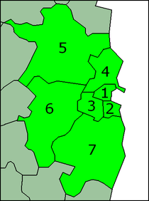 1. Dublin city, 2. Dún Laoghaire–Rathdown, 3. South Dublin, 4. Fingal, 5. Meath, 6. Kildare 7. Wicklow | |
| Country | Ireland |
| Population (2022) | |
| • Total | 2,073,459 |
| Time zone | UTC |
| • Summer (DST) | UTC+1:00 |
| Eircode (post codes) | D1-D17, D2-D24, A41, A45, A63, A67, A82, A83, A84, A85, A86, A91, A92, A98, C15, K32, K45, K56, K67, K78, R56, W91, Y14, Y21 |
| Area code(s) | 01, 041, 042, 045, 046, 0402, 0404 |
Former boundaries
The urban part of Dublin and surrounding areas has been defined by various statutory instruments, mainly those referring to the Garda Síochána and Courts of the Republic of Ireland.
The city and five counties were grouped together in the order creating the Dublin Transportation Office, giving functions and representations to the office in this area, although not using the term.[2] The office was purely advisory and had no executive powers. The term was later defined in section 3 of the Dublin Transport Authority Act 2008.[1] On 1 December 2009 the DTO became the National Transport Authority, with a remit expanding beyond the Greater Dublin Area.[3]
Garda usage
The Garda used the term the Dublin Metropolitan Region (DMR) which was formerly the jurisdiction, within the eastern part of Ireland, of the Dublin Metropolitan Police, which was subsequently merged into the Garda Síochána, the national police force of Ireland. The term originated from the Police Forces Amalgamation Act 1925, which amalgamated the Dublin Metropolitan Police and Garda Síochána as one national police force.[4]
This jurisdiction covered parts of the old County Dublin (except the northern part around Swords) as well as the County Kildare town of Leixlip and the County Wicklow towns of Bray, Greystones and Enniskerry. Swords was covered by the Meath Garda Division. In this way, it differed from the usual definition of County Dublin and did not even conform to the looser definition of the Greater Dublin Area.
The definition no longer applies, as during 2008 the Garda divisions were realigned along Regional and county boundaries. As of 2009, the Dublin Metropolitan Region is co-extensive with the combined area of the city of Dublin, and the counties of Dún Laoghaire–Rathdown, Fingal and South Dublin. Leixlip was moved to the County Kildare Division and became the district headquarters for the new Leixlip District.[5] Bray moved into the new County Wicklow Division and became district headquarters for the Bray District.[6]
Planning usage
The 2003 Regional Planning Guidelines referred to the Greater Dublin Area as a planning district separated into a "metropolitan area" and a "hinterland area".[7]
The "metropolitan area" included both suburbs and commuter towns, covering the area from Swords and Malahide in Fingal, to Greystones in County Wicklow in the south, and as far west as Kilcock in County Kildare. This area differs from the Garda "metropolitan region" scope, in that it stretches approximately 20 km further west.
The Dublin Metropolitan Area is now defined as:[8]
| Local government area | Area within DMA |
|---|---|
| Dublin city | Whole territory |
| Dún Laoghaire–Rathdown | County, except for parts of the electoral divisions of Tibradden and Glencullen comprising the townlands of Stackstown, Ticknock, Kilmashogue, Tibradden, Ballybrack, Glendoo, Boranaraltry, Glencullen Mountain and Brockery. |
| South Dublin | County, except for parts of Rathcoole, Saggart, Ballinacorny and Bohernabreen comprising the townlands of Aghfarrell, Allagour, Ballinascorney (Lower and Upper), Ballymaice, Ballymorefi nn, Belgard Deer Park, Brittas (Big and Little), Calliaghstown Upper, Castlekelly, Corrageen, Cunard, Friarstown Lower, Glassamucky, Glassamucky Brakes, Glassamucky Mountain, Glassavullaun, Glenaraneen, Glendoo, Gortlum, Killakee, Lugg, Mountpelier, Mountseskin, Piperstown, Raheen, Slademore, Slievethoul and parts of the townlands of Crockaunadreenagh*, Crooksling*, Cruagh*, Ballymana, Calliaghstown Lower, Coolmine, Corbally, Jamestown (ED Whitechurch), Killinardan, Kiltalown, Lugmore*, Kiltipper, Newtown Upper, Orlagh, Redgap, Saggart, Slade, Tibradden and Woodtown.
* These townlands are more than 50% in the hinterland area. |
| Fingal | Electorial divisions including Airport, Baldoyle, Balgriffin, Blanchardstown (Abbotstown, Blakestown, Coolmine, Corduff, Delwood, Mulhuddart, Roselawn, Tyrrelstown), Castleknock (Knockmaroon, Park), Donabate, Dubber, Howth, Kilsallaghan, Kinsaley, Lucan North, Malahide (East and West), Portmarnock (North and South), Sutton, Swords (Forrest, Glasmore, Lissenhall, Seatown, Village), The Ward, Turnapin. |
| County Kildare | Electoral divisions of Celbridge, Donaghcumper, Kilcock, Leixlip, Maynooth, Straffan. |
| County Meath | Electoral divisions of Dunboyne and Rodanstown. |
| County Wicklow | Electoral divisions of Bray No.1, Bray No. 2, Bray No. 3, Rathmichael, Delgany, Greystones and the following townlands in the Kilmacanogue electoral division: Corrigoona Commons West, Corrigoona Commons East, Glencormick North, Glencormick South, Kilcroney, Wingfield, Hollybrook, Kilmacanogue North, Kilmacanogue South, and Barchuillia Commons. |
The Dublin "Hinterland" area is aligned with the Draft National Planning Framework, which defines city regions or urban hinterlands as those EDs where at least 15% of the workforce (Full POWCAR) are employed in the Dublin Metropolitan Area (NTA boundary).
Gallery
 Upper O'Connell Street in central Dublin city
 Dun Laoghaire harbour in Dun Laoghaire-Rathdown
 Central Tallaght in South Dublin
 Main Street in Swords, Fingal
 Killegland Street in Ashbourne, Meath
 The National University of Ireland at Maynooth, Kildare
 Bray Daly DART station in Bray, Wicklow


Population

Dublin City (Red)
Dublin City and suburbs (Orange)
Dublin Metropolitan Area (Yellow)
Greater Dublin Area (Green)
The population of the Dublin City and County (Dublin City, Fingal, South Dublin and Dún Laoghaire–Rathdown) and Outer Greater Dublin (Meath, Kildare and Wicklow) as of the 2022 census was 2,073,459 persons. This equates to 40.5% of Ireland's population. Estimates published by the Central Statistics Office suggest that the population will reach 2.4 million by 2026.[9] The figures are based on a regional breakdown of previously published national population projections and assume that current demographic trends will continue.
The CSO also uses the narrower definition which comprises Dublin City and its suburbs within the 3 local Dublin authorities. [10] The boundaries for suburbs are not legally defined, but drawn and revised by the CSO in accordance with United Nations recommendations.[11] The population distribution of the Greater Dublin Area as of the 2011, 2016 and 2022 censuses was as follows:[12][13]
| Administrative division | Population | Population increase 2016 to 2022 | ||||
|---|---|---|---|---|---|---|
| 2011 | 2016 | 2022 | ||||
| Dublin City | 527,612 | 553,165 | 588,233 | 35,068 | ||
| Dún Laoghaire–Rathdown | 206,261 | 217,274 | 233,457 | 16,183 | ||
| Fingal | 273,991 | 296,214 | 329,218 | 33,004 | ||
| South Dublin | 265,205 | 278,749 | 299,793 | 21,044 | ||
| County Dublin | 1,273,069 | 1,345,402 | 1,450,701 | 105,299 | ||
| County Meath | 184,135 | 194,942 | 220,296 | 25,252 | ||
| County Kildare | 210,312 | 222,130 | 246,977 | 24,473 | ||
| County Wicklow | 136,640 | 142,332 | 155,485 | 13,060 | ||
| Meath, Kildare, Wicklow | 531,087 | 559,404 | 622,758 | 63,354 | ||
| Greater Dublin Area | 1,804,156 | 1,904,806 | 2,073,459 | 168,653 | ||
Historical
| Census year | Population | Population change since previous census |
Percentage of population of Ireland | |
|---|---|---|---|---|
| 1841 | 683,232 | ? | 10.5% | |
| 1851 | 740,597 | in 10 years | ||
| 1861 | 698,050 | in 10 years | ||
| 1871 | 663,131 | in 10 years | ||
| 1881 | 652,569 | in 10 years | ||
| 1891 | 628,539 | in 10 years | ||
| 1901 | 640,093 | in 10 years | ||
| 1911 | 669,625 | in 10 years | ||
| 1926 | 685,242 | in 15 years | ||
| 1936 | 774,791 | in 10 years | ||
| 1946 | 827,725 | in 10 years | ||
| 1961 | 906,347 | in 15 years | ||
| 1971 | 1,062,220 | in 10 years | ||
| 1981 | 1,290,154 | in 10 years | ||
| 1986 | 1,336,119 | in 5 years | ||
| 1991 | 1,350,595 | in 5 years | ||
| 1996 | 1,405,671 | in 5 years | ||
| 2002 | 1,535,446 | in 6 years | ||
| 2006 | 1,662,536 | in 4 years | ||
| 2011 | 1,801,040 | in 5 years | ||
| 2016 | 1,904,806 | in 5 years | ||
| 2022 | 2,073,459 | in 6 years | ||
See also
- Belfast metropolitan area
- Derry Urban Area
- List of metropolitan areas in Europe
References
- Dublin Transport Authority Act 2008, s. 3: Greater Dublin Area (No. 15 of 2008, s. 3). Signed on 16 July 2008. Act of the Oireachtas. Irish Statute Book.
- The Dublin Transportation Office (Establishment) Order 1995 (S.I. No. 289 of 1995). Signed on 7 November 1995. Statutory Instrument of the Government of Ireland. Retrieved 14 March 2022, from Irish Statute Book.
- Public Transport Regulation Act 2009 (No. 27 of 2009). Signed on 27 November 2009. Act of the Oireachtas. Irish Statute Book.
- Police Forces Amalgamation Act 1925, s. 3: Dublin Metropolitan Area (No. 7 of 1925, s. 3). Signed on 2 April 1925. Act of the Oireachtas. Irish Statute Book.
- Bauress, Henry (14 October 2008). "New 24-hour Leixlip garda station opens". Leinster Leader. Archived from the original on 17 February 2013.
- "Bray to become Garda HQ for County Wicklow". Bray People. 9 May 2008. Archived from the original on 2 October 2011. Retrieved 19 June 2014.
- "Draft Regional Report – Greater Dublin Area" (PDF). Regional Planning Guidelines. Dublin and Mid-East Regional Authorities. December 2003. p. 5. Archived from the original (PDF) on 5 January 2004. Retrieved 19 January 2018.
- "DUBLIN Strategic Planning Area (SPA) Socio-Economic Evidence Baseline Report" (PDF). Eastern and Midland Regional Assembly. November 2017. pp. 121–124. Retrieved 14 March 2022.
- "CSO Ireland – Regional Population Projections 2011–2026". Archived from the original on 30 July 2018. Retrieved 30 July 2018.
- "Appendix 2: Dublin Area" (PDF). Census 2006 Volume 1 – Population Classified by Area: Appendices. Central Statistics Office. 26 April 2007. p. 164. Archived from the original (PDF) on 27 September 2007. Retrieved 15 September 2007.
The description Greater Dublin Area in the 2006 Census denotes Dublin City and its suburbs
- Central Statistics Office (Ireland) (26 April 2007). Census 2006 Volume 1 – Population Classified by Area: Appendices. Appendix 2, p.163: Towns (i) Towns with Legally Defined Boundaries.
where urban areas have extended beyond the legally defined town boundary, the Central Statistics Office draws up new boundaries defining the suburban areas of Cities/Boroughs ... for census purposes ... in conformity with United Nations recommendations, as the continuation of a distinct population cluster outside its legally defined boundary in which no occupied dwelling is more than 200 metres distant from the nearest occupied dwelling ... The suburban boundaries were reviewed for each subsequent census. A comprehensive review was carried out as part of the processing phase of the 2006 Census.
- "Population of each Province, County and City, 2016". CSO.ie. Central Statistics Office. Archived from the original on 31 August 2017. Retrieved 16 July 2016.
- "Population of each County and City, 2011". CSO.ie. Central Statistics Office. Archived from the original on 10 March 2018. Retrieved 16 March 2018.
- "Central Statistics Office – Census of Population Database". Archived from the original on 3 August 2009. Retrieved 24 February 2010.
External links
- Eastern and Midland Regional Assembly
- Dublin Regional Authority
- Greater Dublin population to reach two million, from RTÉ News
- Regional Planning Guidelines for the Greater Dublin Area
- Cities/Towns Boundaries CSO page with links to Shapefile data for the boundary of the CSO-defined Greater Dublin Area; readable by Geographic information systems
Regions of County Dublin | ||
|---|---|---|
| ||
| Cities |  | |
| Towns and villages |
| |
| Counties | ||
| Other regions | ||
| Civil sub-divisions |
| |
| Baronies of Dublin |
| |
Другой контент может иметь иную лицензию. Перед использованием материалов сайта WikiSort.org внимательно изучите правила лицензирования конкретных элементов наполнения сайта.
WikiSort.org - проект по пересортировке и дополнению контента Википедии