world.wikisort.org - Iran
Iranshahr (Persian: ايرانشهر, Balochi: اڃرانشهر, also Romanized as Īrānshahr; formerly, Pahrah, Fahrej, and Qal'eh-ye Nāşerī)[2] is an Iranian city which serves as the capital of Iranshahr County, Sistan and Baluchestan Province. As of 2010 the population of Iranshahr was 100,000. The city is predominantly inhabited by ethnic Baloch speaking the Balochi language.
This article uses bare URLs, which are uninformative and vulnerable to link rot. (August 2022) |
Iranshahr
ايرانشهر | |
|---|---|
City | |
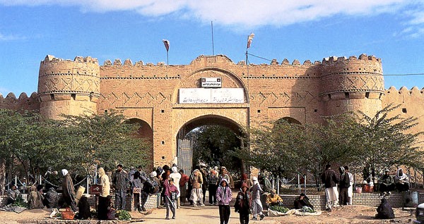 Naseri Castle | |
 Iranshahr | |
| Coordinates: 27°12′09″N 60°41′05″E | |
| Country | Iran |
| Province | Sistan and Baluchestan |
| County | Iranshahr |
| Bakhsh | Central |
| Population (2016 Census) | |
| • Total | 113,750 [1] |
| Time zone | UTC+3:30 (IRST) |
| • Summer (DST) | UTC+4:30 (IRDT) |

Prior to 1935, the city was referred to as Pahrah (Persian: پهرہ), also spelt Poora, Poorah, and Pura, meaning "defence" in Persian.[3] The name was changed to Iranshahr by Mohammad Reza Shah Pahlavi in around 1941.
Pahrah is the site where Alexander the Great celebrated with and regrouped his troops after his Indian conquests. Bampur, where the ancient Bampur fort is located, is nearby the city.
Climate
Iranshahr has a hot desert climate (Köppen climate classification BWh) with extremely hot summers and mild winters. Precipitation is very low, and mostly falls in winter.
| Climate data for Iranshahr | |||||||||||||
|---|---|---|---|---|---|---|---|---|---|---|---|---|---|
| Month | Jan | Feb | Mar | Apr | May | Jun | Jul | Aug | Sep | Oct | Nov | Dec | Year |
| Record high °C (°F) | 30.0 (86.0) |
33.0 (91.4) |
38.0 (100.4) |
43.0 (109.4) |
48.0 (118.4) |
49.0 (120.2) |
49.0 (120.2) |
50.0 (122.0) |
47.0 (116.6) |
44.0 (111.2) |
37.0 (98.6) |
33.0 (91.4) |
50.0 (122.0) |
| Average high °C (°F) | 21.4 (70.5) |
23.4 (74.1) |
29.2 (84.6) |
35.0 (95.0) |
41.3 (106.3) |
44.9 (112.8) |
44.6 (112.3) |
43.6 (110.5) |
40.7 (105.3) |
35.8 (96.4) |
29.5 (85.1) |
23.6 (74.5) |
34.4 (93.9) |
| Daily mean °C (°F) | 15.3 (59.5) |
17.7 (63.9) |
22.7 (72.9) |
28.4 (83.1) |
34.8 (94.6) |
38.3 (100.9) |
38.1 (100.6) |
37.1 (98.8) |
33.9 (93.0) |
28.9 (84.0) |
22.4 (72.3) |
17.0 (62.6) |
27.9 (82.2) |
| Average low °C (°F) | 7.6 (45.7) |
9.8 (49.6) |
14.0 (57.2) |
19.0 (66.2) |
24.4 (75.9) |
28.7 (83.7) |
29.8 (85.6) |
28.2 (82.8) |
24.1 (75.4) |
18.7 (65.7) |
12.6 (54.7) |
8.6 (47.5) |
18.8 (65.8) |
| Record low °C (°F) | −2 (28) |
−1.0 (30.2) |
4.0 (39.2) |
10.0 (50.0) |
14.4 (57.9) |
22.0 (71.6) |
22.0 (71.6) |
20.0 (68.0) |
14.0 (57.2) |
8.0 (46.4) |
2.0 (35.6) |
−6.0 (21.2) |
−6.0 (21.2) |
| Average precipitation mm (inches) | 24.8 (0.98) |
25.0 (0.98) |
19.2 (0.76) |
5.6 (0.22) |
2.6 (0.10) |
2.6 (0.10) |
14.3 (0.56) |
5.2 (0.20) |
1.5 (0.06) |
0.8 (0.03) |
1.5 (0.06) |
11.6 (0.46) |
114.7 (4.51) |
| Average rainy days | 4.6 | 4.0 | 3.7 | 1.8 | 0.8 | 0.7 | 2.0 | 1.2 | 0.3 | 0.2 | 0.5 | 3.0 | 22.8 |
| Average snowy days | 0.1 | 0 | 0 | 0 | 0 | 0 | 0 | 0 | 0 | 0 | 0 | 0 | 0.1 |
| Average relative humidity (%) | 46 | 43 | 36 | 29 | 22 | 23 | 28 | 27 | 24 | 26 | 31 | 40 | 31 |
| Mean monthly sunshine hours | 232.9 | 223.5 | 249.4 | 254.3 | 314.0 | 291.9 | 265.3 | 280.8 | 276.1 | 292.4 | 277.8 | 241.6 | 3,200 |
| Source: NOAA (1964-1990) [4] | |||||||||||||
References
- "Statistical Center of Iran > Home".
- Iranshahr, Iran can be found at GEOnet Names Server, at this link, by opening the Advanced Search box, entering "-3067262" in the "Unique Feature Id" form, and clicking on "Search Database".
- https://www.vajehyab.com/moein/%D9%BE%D9%87%D8%B1%D9%87
- "Iranshahr Climate Normals 1964-1990". National Oceanic and Atmospheric Administration. Retrieved December 19, 2012.
| Capital |  | ||||||||||||||||||||||||||||||||||||||||||||||||
|---|---|---|---|---|---|---|---|---|---|---|---|---|---|---|---|---|---|---|---|---|---|---|---|---|---|---|---|---|---|---|---|---|---|---|---|---|---|---|---|---|---|---|---|---|---|---|---|---|---|
| Counties and cities |
| ||||||||||||||||||||||||||||||||||||||||||||||||
| Sights |
| ||||||||||||||||||||||||||||||||||||||||||||||||
| Populated places |
| ||||||||||||||||||||||||||||||||||||||||||||||||
| Capital |
| ||||||||||||||||||||||
|---|---|---|---|---|---|---|---|---|---|---|---|---|---|---|---|---|---|---|---|---|---|---|---|
| Districts |
| ||||||||||||||||||||||
На других языках
[de] Irānschahr
Irānschahr oder auch Irānshahr (persisch ايرانشهر; bis 1935 Faradsch) ist eine Stadt in der Provinz Sistan und Belutschistan im Südosten des Iran. In der Stadt leben vor allem Belutschen und sprechen die Belutschische Sprache.- [en] Iranshahr, Iran
[ru] Ираншехр
Иранше́хр[1] (перс. ایرانشهر) — город на юго-востоке Ирана, в провинции Систан и Белуджистан. Административный центр шахрестана Ираншехр.Другой контент может иметь иную лицензию. Перед использованием материалов сайта WikiSort.org внимательно изучите правила лицензирования конкретных элементов наполнения сайта.
WikiSort.org - проект по пересортировке и дополнению контента Википедии