world.wikisort.org - Iran
Firuzkuh County (Persian: شهرستان فیروزکوه) is a county (shahrestan) in Tehran Province of Iran. It has an area of 2,386 km2. The administrative centre of the county is the city of Firuzkuh. At the 2011 census, the county's population was 38,712, but the provisional results of the 2016 census showed a decline to 33,558.[1] The county is subdivided into two districts: the Central District and Arjomand District. The county has two cities: Firuzkuh and Arjomand.
Firuzkuh County
شهرستان فیروزکوه | |
|---|---|
County (Shahrestan) | |
 Tang e Vashi, in the county | |
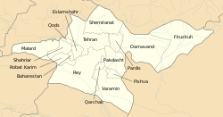 Counties of Tehran Province | |
 Location of Tehran Province in Iran | |
| Coordinates: 35°44′N 52°45′E | |
| Country | |
| Province | Tehran |
| Capital | Firuzkuh |
| Bakhsh (Districts) | Central District, Arjomand District |
| Area | |
| • Total | 2,386 km2 (921 sq mi) |
| Population (2016)(Census, provisional) | |
| • Total | 33,558 |
| • Density | 14.06/km2 (36.4/sq mi) |
| Time zone | UTC+3:30 (IRST) |
| • Summer (DST) | UTC+4:30 (IRDT) |
| Firuzkuh County can be found at GEOnet Names Server, at this link, by opening the Advanced Search box, entering "9206116" in the "Unique Feature Id" form, and clicking on "Search Database". | |
References
- Statistical Centre of Iran (web).
- اطلس گیتاشناسی استانهای ایران [Atlas Gitashenasi Ostanhai Iran] (Gitashenasi Province Atlas of Iran)
| Capital |
| |||||||||||||||||||||||||||||||||
|---|---|---|---|---|---|---|---|---|---|---|---|---|---|---|---|---|---|---|---|---|---|---|---|---|---|---|---|---|---|---|---|---|---|---|
| Counties and cities |
| |||||||||||||||||||||||||||||||||
| Landmarks |
| |||||||||||||||||||||||||||||||||
| Populated places |
| |||||||||||||||||||||||||||||||||
^* indicates that this formerly independent city is now absorbed into Tehran. | ||||||||||||||||||||||||||||||||||

| Capital |
| ||||||||||||||||||||||
|---|---|---|---|---|---|---|---|---|---|---|---|---|---|---|---|---|---|---|---|---|---|---|---|
| Districts |
| ||||||||||||||||||||||
External links
Wikimedia Commons has media related to Firuzkuh County.
This Firuzkuh County location article is a stub. You can help Wikipedia by expanding it. |
Текст в блоке "Читать" взят с сайта "Википедия" и доступен по лицензии Creative Commons Attribution-ShareAlike; в отдельных случаях могут действовать дополнительные условия.
Другой контент может иметь иную лицензию. Перед использованием материалов сайта WikiSort.org внимательно изучите правила лицензирования конкретных элементов наполнения сайта.
Другой контент может иметь иную лицензию. Перед использованием материалов сайта WikiSort.org внимательно изучите правила лицензирования конкретных элементов наполнения сайта.
2019-2026
WikiSort.org - проект по пересортировке и дополнению контента Википедии
WikiSort.org - проект по пересортировке и дополнению контента Википедии