world.wikisort.org - Indonesia
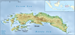
West Seram Regency is a regency of Maluku, Indonesia. It is mainly located on the island of Seram, but includes various islands lying to the west of Seram -- Manipa, Kelang, Boano, as well as the smaller islets of Babi, Pua, Masowoi and Marsegu. It covers a land area of 6,948.40 km2, and had a population of 164,654 at the 2010 Census[2] and 212,393 at the 2020 Census.[3] The principal town lies at Piru, a port at the northern coast of Latira Bay (Teluk Latira) which almost separates the Huamual Peninsula from the rest of Seram Island. The western sector of the Regency (the Huamual Peninsula and the islands off the west coast) occupies just under 25% of the land area, but held over 42% of the Regency's population at the 2020 Census.
West Seram Regency
Kabupaten Seram Bagian Barat | |
|---|---|
Regency | |
 Coat of arms | |
| Motto(s): Saka Mese Nura (Protect and Defend the Island) | |
 Location within Maluku | |
 West Seram Regency Location in Seram, Maluku and Indonesia  West Seram Regency West Seram Regency (Maluku)  West Seram Regency West Seram Regency (Indonesia) | |
| Coordinates: 3.1027°S 128.4300°E | |
| Country | Indonesia |
| Province | Maluku |
| Capital | Piru |
| Government | |
| • Regent | Jacobus F. Puttileihalat |
| • Vice Regent | Timotius Akerina |
| Area | |
| • Total | 6,948.4 km2 (2,682.8 sq mi) |
| Population (2020 Census)[1] | |
| • Total | 212,393 |
| • Density | 31/km2 (79/sq mi) |
| Time zone | UTC+9 (IEST) |
| Area code | (+62) 911 |
| Website | sbbkab |
Administrative districts
At the time of the 2010 Census the regency was divided into four districts (kecamatan). Subsequent to 2010, seven additional districts have been created by the division of the original four districts, so that the regency is now divided into eleven districts. These are tabulated below with their areas and populations at the 2010 Census and 2020 Census.[4] The table also includes the location of the district headquarters, as well as the number of villages (desa) in each district, and its postal code.
| Name | Area in km2 | Population Census 2010 | Population Census 2020 | Administrative centre | No. of villages | Post code |
|---|---|---|---|---|---|---|
| Huamual Belakang (a) | 409.65 | 25,629 | 33,132 | Waesah | 7 | 97567 |
| Kepulauan Manipa (Manipa Islands) (b) | 159.71 | 5,810 | 7,165 | Masawoi | 7 | 97569 |
| Huamual (c) | 1,162.99 | 34,919 | 49,097 | Luhu | 5 | 97560 |
| Totals of Western sector | 1,732.35 | 66,358 | 89,394 | 19 | ||
| Seram Barat (West Seram) | 503.33 | 27,311 | 35,045 | Piru | 7 | 97562 |
| Kairatu | 329.65 | 23,240 | 27,040 | Kairatu | 7 | 97566 |
| Kairatu Barat (d) (West Kairatu) | 132.25 | 13,146 | 14,478 | Kamal | 6 | 97568 |
| Inamosol (d) | 504.61 | 5,311 | 6,422 | Honitetu | 5 | 97565 |
| Amalatu (d) | 665.35 | 10,979 | 12,537 | Latu | 7 | 97563 |
| Elpaputih (d) | 1,165.74 | 1,453 | 5,233 | Elpaputih | 7 | 97564 |
| Taniwel | 1,181.32 | 12,133 | 15,448 | Taniwel | 19 | 97559 |
| Taniwel Timur (e) (East Taniwel) | 733.80 | 5,375 | 6,796 | Uwen Pantai | 15 | 97561 |
| Totals of Eastern sector | 5,216.05 | 98,948 | 122,999 | 73 | ||
| Totals | 6,948.40 | 164,654 | 212,393 | 92 |
Notes: (a) Huamual Belakang District includes Boano, Kelang, Babi and Pua Islands, and 26 other small islands, as well as part of the 'mainland' of Seram.
(b) Manipa Islands District consists of the main island of Manipa together with adjacent small islands; it was formerly part of Huamual Belakang District.
(c) formerly part of Seram Barat District. (d) formerly part of Kairatu District. (e) formerly part of Taniwel District.
References
- Badan Pusat Statistik, Jakarta, 2021.
- Biro Pusat Statistik, Jakarta, 2011.
- Badan Pusat Statistik, Jakarta, 2021.
- Badan Pusat Statistik, Jakarta, 2021.
External links
Authority control | |
|---|---|
| General | |
| National libraries | |
На других языках
[de] Westseram
Seram Bagian Barat ist ein indonesischer Regierungsbezirk (Kabupaten) in der indonesischen Provinz Maluku. Stand 2020 leben hier circa 211.700 Menschen.[1] Der Regierungssitz von Westseram ist Piru.- [en] West Seram Regency
Другой контент может иметь иную лицензию. Перед использованием материалов сайта WikiSort.org внимательно изучите правила лицензирования конкретных элементов наполнения сайта.
WikiSort.org - проект по пересортировке и дополнению контента Википедии