world.wikisort.org - India
Ziro is a town and the district headquarters of the Lower Subansiri district in the Indian state of Arunachal Pradesh. It is included the Tentative List for UNESCO's World Heritage Site for the Apatani cultural landscape.[1][2][3][4] The part of the town which is the centre of economic activities and where the administrative offices are located is called as Hapoli or locally known by the Apatanis as "Hao-Polyang".
Ziro | |
|---|---|
Town | |
 A cross section of luch green valley of Ziro | |
 Ziro Location in Arunachal Pradesh, India  Ziro Ziro (India) | |
| Coordinates: | |
| Country | |
| State | |
| District | Lower Subansiri |
| Population (2011) | |
| • Total | 12,806 |
| Languages | |
| • Official | English |
| Time zone | UTC+5:30 (IST) |
| Vehicle registration | AR |
| Climate | Cwa |
Ziro is 115 km from Itanagar, 123 km from the nearest civil airport at Lilabari, 96 km from Naharlagun railway station.[citation needed] IAF's ALG airstrip is at Ziro.[5][6]

Geography
Ziro is the district headquarter of Lower Subansiri district and is one of the oldest towns in Arunachal Pradesh. It is located at 27.63°N 93.83°E[7] at an elevation of 1688 metres (5538 feet) to 2438 meters (8000 feet). Its cool weather in summer is its major attraction. It is famous for its surrounding pine-clad gentle hills and its rice fields. Ziro is home to the Apatani tribe.
Transport
Ziro is around 115 km from the state capital Itanagar and takes approx 3 and a half hours via the improved Hoj-Potin road along NH229 and 150 km via the Assam route. Earlier the nearest railway station from Ziro was located at Naharlagun in Arunachal Pradesh near the Arunachal-Assam border which is around 100 km from Ziro. The nearest airport to the settlement is Lilabari, in North Lakhimpur district of Assam (India).[citation needed]
Ziro is also an Advance Landing Ground (ALG) of Indian Air Force.[5][6]
Climate
The climatic condition of the district varies from place to place as well as season to season. Its climate is largely influenced by the nature of terrain depending upon altitude and location of the place. It could be broadly be divided into four seasons in a year:
- The cold weather season is from December to February
- March to May is the pre-monsoon season of thunderstorms
- The southwest monsoon from June to about the middle of October
- The second half of October to November, which constitutes the post-monsoon or the retreating monsoon period and is a period of transition
In the foothills or low high belt area of the district, the climatic condition is moderate in comparison to high belt areas, where during winter it is very cold and chilly, and in summer is pleasant. December and January are generally the coldest months, and July and August are warmest months.
Annual rainfall in the south is heavier than that in the northern areas of the district. During the monsoon period, more than 70 percent of the rain over the southern half occurs while in the northern portions it is about 60 percent. Variability of rainfall for the monsoon and the year, as a whole, are relatively small. Average annual rainfall of the district headquarters, Ziro recorded as 934.88 cm during 2000.
The relative humidity is always high throughout the year except in the winter months being slightly less humid. In the cold season, the sky is obscured on many mornings due to lifted fog which clears with the advance of the day generally, moderately clouded in the period of March to May, heavily clouded to overcast in the monsoon season and clear or slightly clouded during the post-monsoon season. Winds are generally light strong katabatic winds down the valleys are experienced as the local effect produced by the nature of the terrain.
| Climate data for Ziro | |||||||||||||
|---|---|---|---|---|---|---|---|---|---|---|---|---|---|
| Month | Jan | Feb | Mar | Apr | May | Jun | Jul | Aug | Sep | Oct | Nov | Dec | Year |
| Record high °C (°F) | 21.5 (70.7) |
19.7 (67.5) |
26.2 (79.2) |
28.3 (82.9) |
30.3 (86.5) |
33.4 (92.1) |
31.9 (89.4) |
32.3 (90.1) |
32.3 (90.1) |
30.2 (86.4) |
28.9 (84.0) |
25.2 (77.4) |
33.4 (92.1) |
| Average high °C (°F) | 12.9 (55.2) |
13.2 (55.8) |
16.8 (62.2) |
19.1 (66.4) |
21.0 (69.8) |
23.3 (73.9) |
25.0 (77.0) |
25.1 (77.2) |
24.0 (75.2) |
23.4 (74.1) |
18.3 (64.9) |
15.8 (60.4) |
19.8 (67.6) |
| Average low °C (°F) | −0.2 (31.6) |
2.3 (36.1) |
4.7 (40.5) |
8.3 (46.9) |
12.4 (54.3) |
14.7 (58.5) |
15.8 (60.4) |
15.1 (59.2) |
13.7 (56.7) |
10.1 (50.2) |
4.4 (39.9) |
0.4 (32.7) |
8.5 (47.3) |
| Record low °C (°F) | −6.7 (19.9) |
−3.0 (26.6) |
−0.4 (31.3) |
1.4 (34.5) |
3.4 (38.1) |
7.6 (45.7) |
9.2 (48.6) |
10.2 (50.4) |
9.0 (48.2) |
2.0 (35.6) |
−4.2 (24.4) |
−5.7 (21.7) |
−6.7 (19.9) |
| Average rainfall mm (inches) | 88.7 (3.49) |
106.1 (4.18) |
78.6 (3.09) |
169.0 (6.65) |
199.5 (7.85) |
292.5 (11.52) |
249.0 (9.80) |
232.4 (9.15) |
199.9 (7.87) |
64.1 (2.52) |
51.2 (2.02) |
13.6 (0.54) |
1,744.3 (68.67) |
| Average rainy days (≥ 2.5 mm) | 5.2 | 7.3 | 6.8 | 10.8 | 13.1 | 15.7 | 14.5 | 14.6 | 12.8 | 4.8 | 3.4 | 1.5 | 110.5 |
| Average relative humidity (%) (at 17:30 IST) | 75 | 76 | 78 | 79 | 75 | 77 | 76 | 77 | 77 | 81 | 79 | 75 | 77 |
| Source: India Meteorological Department[8] | |||||||||||||
Demography
As of 2011[update] India census,[9] Ziro had a population of 12,806. Males constitute 50% of the population and females 50%. In Ziro, 17% of the population is under 6 years of age.
Languages
According to 2011 census, Nishi was the most spoken language in Itanagar with 8,068 speakers followed by Bengali at 1,104, Assamese at 752, Nepali at 746, Bhojpuri at 728 and Hindi at 395.
Culture
Apatani culture
Apatanis have few unique special characteristic features which differ from other tribes in Arunachal Pradesh and India. Few of these special characteristic features are:
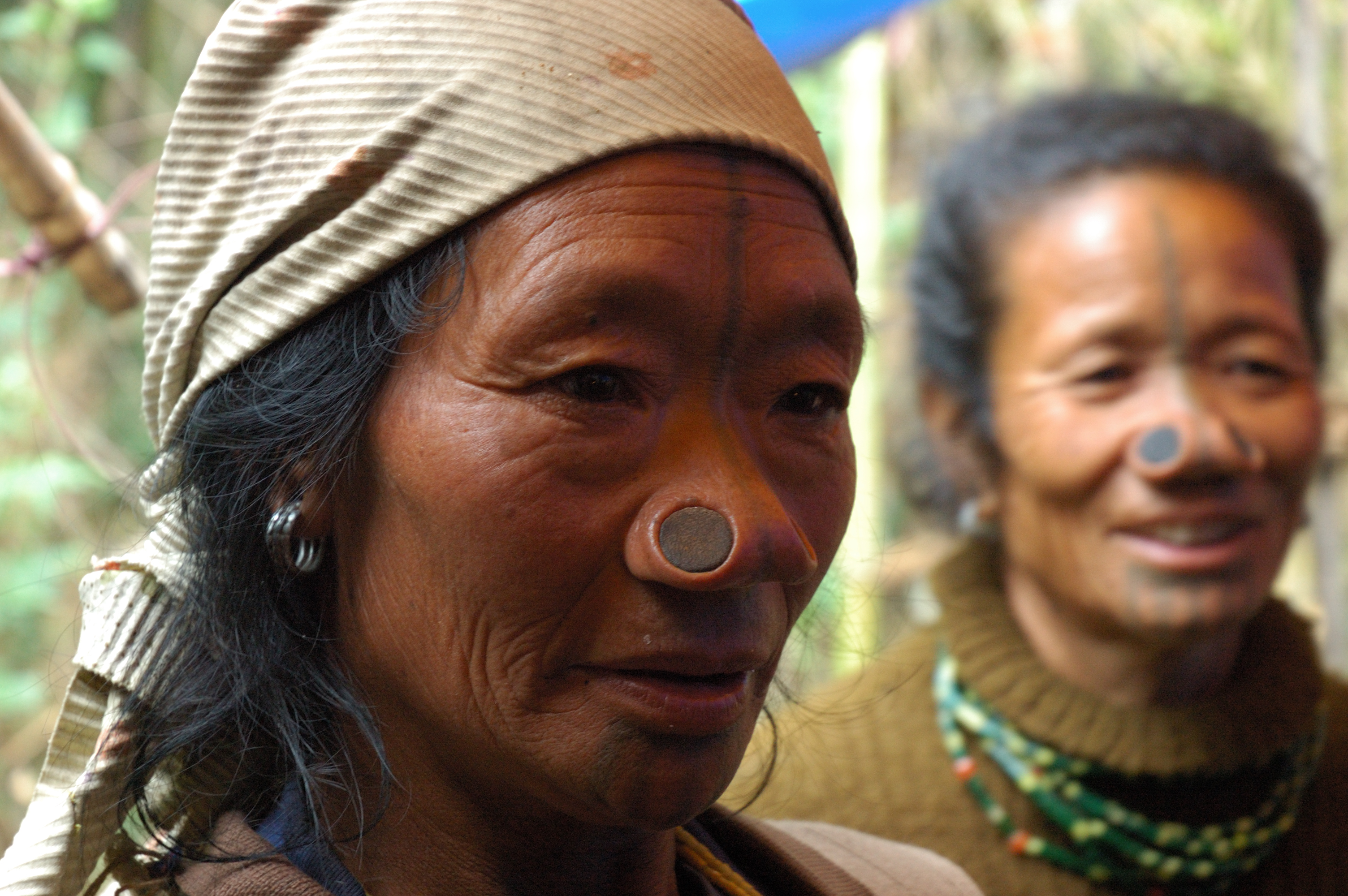
(A) Apatanis practice permanent wet paddy cultivation whereas other tribes practice shifting cultivation called Jhom cultivation. (B) Apatanis cultivate permanent wet land cultivations whereas other tribes practice dry land cultivations by clearing the forests by burning the jungles. (C) Apatanis once practiced the art of facial tattoos.
UNESCO world heritage cultural sites

Apatani cultural landscape in Ziro Valley in Lower Subansiri district and Thembang Dzong in West Kameng district have been included in the Tentative List for UNESCO's World Heritage Site. The Arunachal Pradesh government has undertaken conservation works at these sites with the aim of ensuring inclusion of these sites in UNESCO's final list.[1] Apatani cultural landscape comprises 32 sq km2 cultivable areas out of 1058 sq km plateau.[2] Apatani tribe, which has inhabited this region for centuries, is known for practicing ecologically sustainable existential sustenance.[3] Thembang Dzong is a 3.2 acres fortified village of Monpa tribe.[1]
Education

Ziro has one university and one undergraduate arts college namely Indira Gandhi Technological and Medical Sciences University and Saint Claret College respectively. As of the 2001 census, Ziro had an average literacy rate of 66%, lower than the national average of 74.04%: male literacy was 72%, and female literacy was 60%. The older generation hadn't been exposed to formal education, but with the rapid pace of education of younger generations, the education scenario of Ziro grew tremendously and is poised to grow further.
Urban populace of Lower Subansiri district mainly reside in Ziro and as per 2011 census,[11] average urban literacy rate in Lower Subansiri district is 85.52% of which males and females are 89.81% and 81.26% literates respectively. It is worth noting that, as per the 2011 census, 84.58% population of Lower Subansiri districts lives in rural areas of villages. The literacy rate in rural areas of Lower Subansiri district is 72.27%. Still, the combined literacy rate is 74.35%, which is second in Arunachal Pradesh, next only to Papumpare District where the capital city of Itanagar is located.
See also
- New Palin, a town in the Kurung Kumey district
References
- Arunachal Pradesh Seeks UNESCO World Heritage Tag For Two Sites, NDTV, 9 Fb 2018.
- Apatani cultural landscape, UNESCO tentative list, UNESCO, site submitted to UNESCO on 15 April 2014. Accessed: 14 November 2020.
- Das, Gaurav (21 July 2018). "Heritage cloud on land of the dawn-lit mountains". Telegraph India. Retrieved 2 October 2022.
- "Arunachal's Ziro Valley, Talley Valley for UNESCO Word Heritage Site | Northeast Today". Archived from the original on 18 December 2012. Retrieved 13 December 2012.
- Karmakar, Rahul (18 September 2019). "New IAF 'airport' in Arunachal provides an alternative to walking 157 km". The Hindu. Retrieved 2 October 2022.
- Sharma, Kushal Dev (19 June 2020). "How India defends its border with China". The Economic Times. Retrieved 2 October 2022.
- "Maps, Weather, and Airports for Ziro, India". Falling Rain. 12 December 2021. Retrieved 2 October 2022.
- "Climate of North Eastern States" (PDF). Climatological Summaries of States Series - No. 19. India Meteorological Department. December 2013. pp. 264–269. Archived from the original (PDF) on 19 February 2020. Retrieved 8 March 2020.
- "Census of India 2011: Data from the 2011 Census, including cities, villages and towns (Provisional)". Census Commission of India. Archived from the original on 16 June 2004. Retrieved 1 November 2008.
- https://censusindia.gov.in/nada/index.php/catalog/10194
- "Arunachal Pradesh Population Sex Ratio in Arunachal Pradesh Literacy rate data 2011-2021".
External links
| Leadership |
| ||||||||||||||||||||||||||||||||||||||||||||
|---|---|---|---|---|---|---|---|---|---|---|---|---|---|---|---|---|---|---|---|---|---|---|---|---|---|---|---|---|---|---|---|---|---|---|---|---|---|---|---|---|---|---|---|---|---|
| Components & commands |
| ||||||||||||||||||||||||||||||||||||||||||||
| Military academies |
| ||||||||||||||||||||||||||||||||||||||||||||
| Insignia |
| ||||||||||||||||||||||||||||||||||||||||||||
| History & future |
| ||||||||||||||||||||||||||||||||||||||||||||
| Other |
| ||||||||||||||||||||||||||||||||||||||||||||
| |||||||||||||||||||||||||||||||||||||||||||||
Authority control | |
|---|---|
| General | |
| National libraries | |
На других языках
- [en] Ziro
[ru] Зиро (город)
Зиро (англ. Ziro) — город в Индии на западе центральной части индийского штата Аруначал-Прадеш. Административный центр округа Нижний Субансири.Другой контент может иметь иную лицензию. Перед использованием материалов сайта WikiSort.org внимательно изучите правила лицензирования конкретных элементов наполнения сайта.
WikiSort.org - проект по пересортировке и дополнению контента Википедии