world.wikisort.org - India
Rudraprayag is a district of the state of Uttarakhand of northern India. The district occupies an area of 1984 km2. The town of Rudraprayag is the administrative headquarters of the district. The district is bounded by Uttarkashi District on the north, Chamoli District on the east, Pauri Garhwal District on the south, and Tehri Garhwal District on the west.
This article may require cleanup to meet Wikipedia's quality standards. The specific problem is: mess of names, links and comments especially in the "Cities, towns and villages" section. (January 2015) |
Rudraprayag district | |
|---|---|
District of Uttarakhand | |
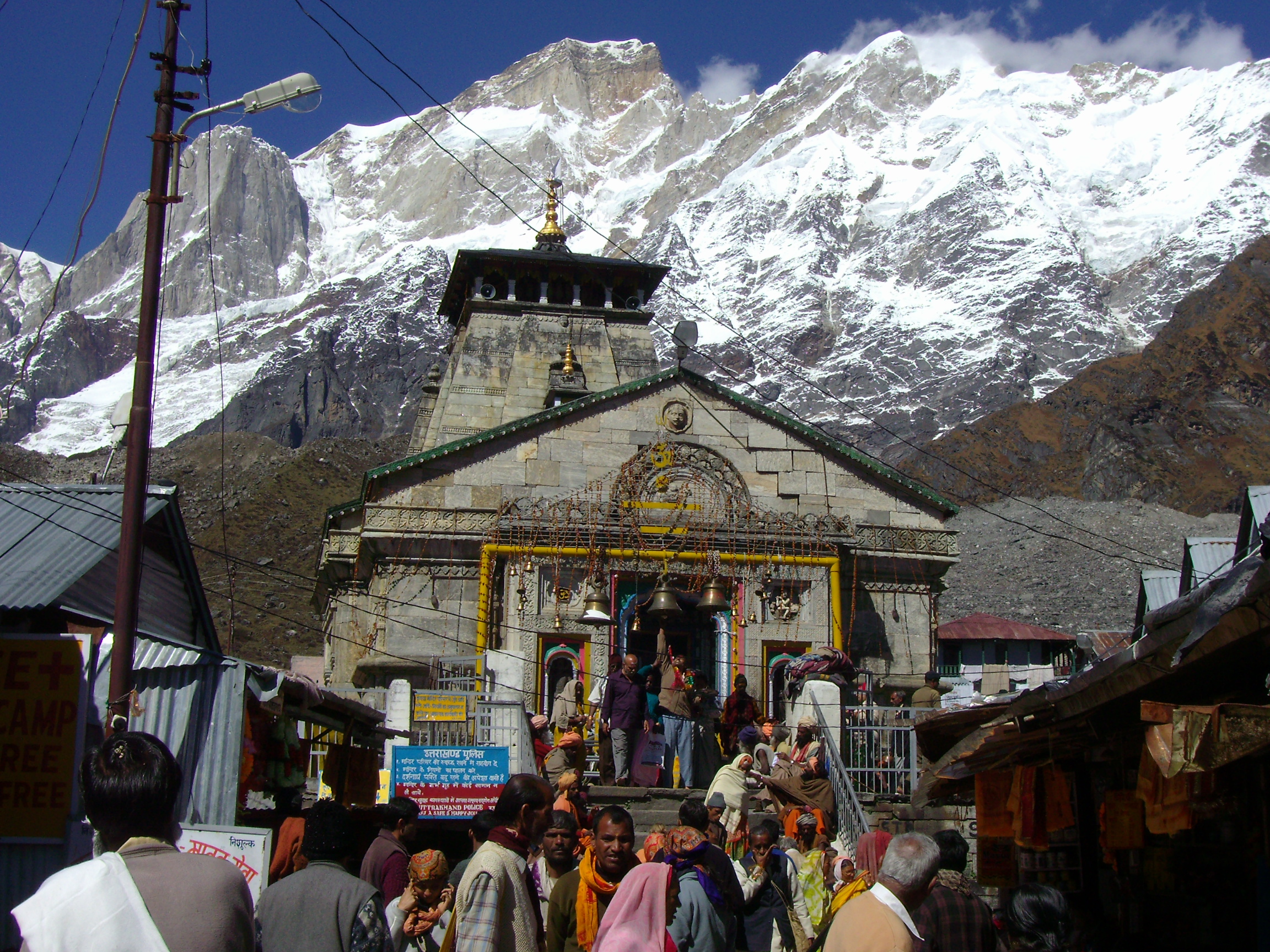     Clockwise from top-left: Kedarnath Temple, Confluence of Alakananda and Mandakini at Rudraprayag, Chaukhamba at Bodha Madhyamaheshwar, Hills at Chopta, Tungnath | |
 Location in Uttarakhand | |
 Rudraprayag district | |
| Country | |
| State | |
| Division | Garhwal division |
| Headquarters | Rudraprayag |
| Government | |
| • District magistrate | Manuj Goyal, IAS[1] |
| Area | |
| • Total | 1,984 km2 (766 sq mi) |
| Population (2011) | |
| • Total | 242,285 |
| • Density | 120/km2 (320/sq mi) |
| ISO 3166 code | IN-UT |
| Vehicle registration | UK 13 |
| Website | rudraprayag |
Overview
Rudraprayag District was established on 16 September 1997. It was carved out from the following areas of three adjoining districts:
- The whole of Augustmuni and Ukhimath block and part of Pokhri and Karnprayag block from Chamoli District
- Part of Jakholi and Kirtinagar block from Tehri District
- Part of Khirsu block from Pauri District
The internationally known Kedarnath Temple is at the north, Madmaheshwar at east, Nagrasu at southern east and Srinagar at extreme south. The Mandakini River is the main river of the district.
As of 2011 it is the least populous district of Uttarakhand (out of 13).[2]
Demographics
| Year | Pop. | ±% p.a. |
|---|---|---|
| 1901 | 70,510 | — |
| 1911 | 78,790 | +1.12% |
| 1921 | 80,700 | +0.24% |
| 1931 | 88,743 | +0.95% |
| 1941 | 100,305 | +1.23% |
| 1951 | 105,848 | +0.54% |
| 1961 | 119,921 | +1.26% |
| 1971 | 135,654 | +1.24% |
| 1981 | 169,743 | +2.27% |
| 1991 | 200,515 | +1.68% |
| 2001 | 227,439 | +1.27% |
| 2011 | 242,285 | +0.63% |
| source:[3] | ||
According to the 2011 census Rudraprayag district has a population of 242,285,[2] roughly equal to the nation of Vanuatu.[5] This gives it a ranking of 585th in India (out of a total of 640).[2] The district has a population density of 119 inhabitants per square kilometre (310/sq mi) .[2] Its population growth rate over the decade 2001-2011 was 4.14%.[2] Rudraprayag has a sex ratio of 1120 females for every 1000 males, making it the 6th highest in the country as per 2011 census, second being Almora that too in uttarakhand,[2] and a literacy rate of 82.09%. Scheduled Castes and Scheduled Tribes make up 19.68% and 0.16% of the population respectively.[2]
The predominant first language of the district is Garhwali, spoken by 94.48% of the population according to the 2011 census. Hindi, though widely used a lingua franca, is the first language of 4.20%, while 0.60% are speakers of Nepali.[6]
| Rudraprayag district: mother-tongue of population, according to the 2011 Indian Census.[6] | |||
|---|---|---|---|
| Mother tongue code | Mother tongue | People | Percentage |
| 006195 | Garhwali | 228,916 | 94.5% |
| 006240 | Hindi | 10,167 | 4.2% |
| 014011 | Nepali | 1,444 | 0.6% |
| – | Others | 1,758 | 0.7% |
| Total | 242,285 | 100.0% | |
Assembly constituencies
- Kedarnath
- Rudraprayag
Shrines and temples
- Kedarnath
- Tungnath
- Madhyamaheshwar
- Mathiyana Devi
- Kalimath Shakti Peeth
Cities, towns and villages in Rudraprayag district
- Rudraprayag
- Sumerpur
- Bawai - 20 km from Rudraprayag city via Maikoti-Durgadhar, and 18 km from Tilwada
- Maikoti
- Biron Dewal village
- Darmwari
- Benji Village
- Triyuginarayan village
- Guptakashi
- Gaurikund
- Jaggi Kandai village
- Bainji Kandai Dashjula village
See also
- Leopard of Rudraprayag
References
- "Who's Who | District Rudraprayag | India". Retrieved 29 July 2022.
- "District Census 2011". Census2011.co.in. 2011. Retrieved 30 September 2011.
- Decadal Variation In Population Since 1901
- "Table C-01 Population by Religion: Uttarakhand". censusindia.gov.in. Registrar General and Census Commissioner of India. 2011.
- US Directorate of Intelligence. "Country Comparison:Population". Archived from the original on 13 June 2007. Retrieved 1 October 2011.
Vanuatu 224,564 July 2011 est.
- "Table C-16 Population by Mother Tongue: Uttarakhand". www.censusindia.gov.in. Registrar General and Census Commissioner of India.
External links
Places adjacent to Rudraprayag district | ||||||||||||||||
|---|---|---|---|---|---|---|---|---|---|---|---|---|---|---|---|---|
| ||||||||||||||||
| Government |
| ||||||||||||||||
|---|---|---|---|---|---|---|---|---|---|---|---|---|---|---|---|---|---|
| History |
| ||||||||||||||||
| Geography and Ecology |
| ||||||||||||||||
| Demographics |
| ||||||||||||||||
| Administrative divisions |
| ||||||||||||||||
| Politics |
| ||||||||||||||||
| Tourism |
| ||||||||||||||||
| Sports |
| ||||||||||||||||
| Other topics |
| ||||||||||||||||
| Districts |
| ||||||||||||||||
| Major cities | |||||||||||||||||
Authority control | |
|---|---|
| General |
|
| National libraries | |
На других языках
[de] Rudraprayag (Distrikt)
Der Distrikt Rudraprayag (Hindi: रुद्र प्रयाग जिला) ist ein Distrikt des indischen Bundesstaats Uttarakhand. Sitz der Distriktverwaltung ist Rudraprayag.- [en] Rudraprayag district
[ru] Рудрапраяг (округ)
Рудрапраяг (англ. Rudraprayag, хинди रुद्रप्रयाग जिला) — округ в индийском штате Уттаракханд в регионе Гархвал. На севере граничит с округом Уттаркаши, на востоке — с округом Чамоли и на юге — с округом Паури-Гархвал. Административный центр округа — Рудрапраяг. Округ был образован 16 сентября 1997 года. В его состав вошли части территорий округов Чамоли, Тихри-Гархвал и Паури-Гархвал.Другой контент может иметь иную лицензию. Перед использованием материалов сайта WikiSort.org внимательно изучите правила лицензирования конкретных элементов наполнения сайта.
WikiSort.org - проект по пересортировке и дополнению контента Википедии