 Gurdwara Sahib Sikh Temple Ramgarh
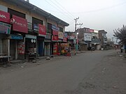 Ramgarh Main Market
 Houses Architecture in Ramgarh Town
world.wikisort.org - India
Ramgarh is a town and a notified area committee in Samba District in the Indian union territory of Jammu and Kashmir. Ramgarh is 9 km (5.6 mi) from Vijaypur city National Highway.
This article has multiple issues. Please help improve it or discuss these issues on the talk page. (Learn how and when to remove these template messages)
|
Ramgarh | |
|---|---|
city | |
 Ramgarh Location in Jammu and Kashmir, India  Ramgarh Ramgarh (India) | |
| Coordinates: 32.5167°N 74.9500°E | |
| Country | |
| State | Jammu and Kashmir |
| District | Samba |
| Population (2001) | |
| • Total | 4,540 |
| Languages | |
| • Official | English Urdu |
| • Others | Hindi Punjabi Dogri Mirpuri |
| Time zone | UTC+5:30 (IST) |
Demographics
As of 2001[update] India census,[1] Ramgarh had a population of 4,540. Males constitute 52% of the population and females 48%. Ramgarh has an average literacy rate of 67%, higher than the national average of 59.5%: male literacy is 75%, and female literacy is 59%. 14% of the population of Ramgarh is under 6 years of age.
Gallery


References
- "Census of India 2001: Data from the 2001 Census, including cities, villages and towns (Provisional)". Census Commission of India. Archived from the original on 16 June 2004. Retrieved 1 November 2008.
Текст в блоке "Читать" взят с сайта "Википедия" и доступен по лицензии Creative Commons Attribution-ShareAlike; в отдельных случаях могут действовать дополнительные условия.
Другой контент может иметь иную лицензию. Перед использованием материалов сайта WikiSort.org внимательно изучите правила лицензирования конкретных элементов наполнения сайта.
Другой контент может иметь иную лицензию. Перед использованием материалов сайта WikiSort.org внимательно изучите правила лицензирования конкретных элементов наполнения сайта.
2019-2025
WikiSort.org - проект по пересортировке и дополнению контента Википедии
WikiSort.org - проект по пересортировке и дополнению контента Википедии