world.wikisort.org - India
Pallikkal (Pallikkal Bazar) is a T-shaped town, village and gram panchayat in Kondotty Taluk, Malappuram district in the state of Kerala, India.[1]
Pallikkal Bazar
Pallikkal | |
|---|---|
Census town | |
 University of Calicut | |
 Pallikkal Bazar Location in Kerala, India  Pallikkal Bazar Pallikkal Bazar (India) | |
| Coordinates: 11°9′0″N 75°54′0″E | |
| Country | |
| State | Kerala |
| District | Malappuram |
| Government | |
| • Type | Local |
| • Body | Grama Panchayat |
| Population (2001) | |
| • Total | 38,166 |
| Languages | |
| • Official | Malayalam, English |
| Time zone | UTC+5:30 (IST) |
| PIN | 673634, 673636 |
| Vehicle registration | KL-84 |
| Nearest city | Kozhikode |
| Nearest major towns | Kondotty, Feroke |
| Lok Sabha constituency | Malappuram |
| Kerala Legislative Assembly Constituency | Vallikkunnu |
| Taluk | Kondotty |
| Telephone Code | 0483, 0494 |


Calicut International Airport at Karipur is near Pallikkal.
Pallikkal Bazar is with in 5 km from the University of Calicut and from Kondotty.
Kerala’s first Akshaya center was started in Pallikal gram panchayat. AMLP School Pallikkal is in Pallikkal Bazar.
Proposed Karipur-Kondotty Municipality
The proposed Karipur-Kondotty Municipality comprises[2]
- Kondotty panchayat (villages of Kondotty, and part of Karipur)
- Nediyiruppu panchayat (villages of Nediyiruppu, and part of Karipur)
- Pallikkal panchayat (villages of Pallikkal, and part of Karipur)
- Pulikkal panchayat
- Cherukavu panchayat
- Vazhayur panchayat
Total Area: 122.99 km2
Total Population (1991 Census): 152,839
Demographics
As of 2001[update] India census, Pallikkal had a population of 38166 with 18945 males and 19221 females.[clarification needed][1]
Landmarks
- Marketile Shihabikka
- Dragon kung fu dojo
- V mark supermarket
- Rasack building
- Pallikkal Bazar Masjid
- Shri Maha Ganapathy Temple
- AMUP School
- VPKMHS School
Suburbs and villages
- UKC, Kavumpadi
- Devathiyal, Puthur-Palikkal and Thottiyil
- Paruthikkode and Arakkott
- Kozhippuram, Pallikkal and College Road
- Koonulmad and Alparamb
- Karippur and Kumminiparamb
Transportation
Calicut International Airport is located in Pallikkal panchayath and is situated around 7 kms away from Pallikkal Bazar town.
The nearest railway stations are at Feroke, Parappanangadi and Vallikunnu. The nearest major railway station at Kozhikode is 20 kms away.
Pallikkal Bazar town and surrounding areas are also well connected by road and local bus transportation systems. National Highway 66 and National Highway 966 are 2.5 kms and 3 kms away respectively from Pallikkal Bazar. The town itself is located on Kakkanchery-Kottapuram road which is a major throughfare and also a major link between NH-66 and NH-966.
Gallery
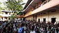 AMUPS school
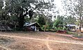 Pallikkal Kavu
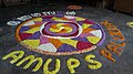 Onam Festival at AMUPS school
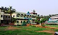 Hidayathu Sibyan Madhrassah
 Pallikkal school


References
- "Census of India : Villages with population 5000 & above". Registrar General & Census Commissioner, India. Retrieved 10 December 2008.
- "Talks on Karipur airport development today". The Hindu. 3 November 2004. Retrieved 3 May 2015.[dead link]
This article related to a location in Malappuram district, Kerala, India is a stub. You can help Wikipedia by expanding it. |
Другой контент может иметь иную лицензию. Перед использованием материалов сайта WikiSort.org внимательно изучите правила лицензирования конкретных элементов наполнения сайта.
WikiSort.org - проект по пересортировке и дополнению контента Википедии