world.wikisort.org - India
Kumbalam is a picturesque region in Kochi, in the state of Kerala, India. A water-bound countryside, bound by the Vembanad Lake, as well as the fast-encroaching city of Kochi, it is situated around 9 km from Vytilla Junction.

This article does not cite any sources. (May 2009) |
Kumbalam
കുമ്പളം | |
|---|---|
Locality | |
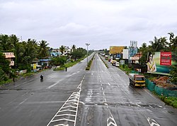
 NH 47 view from Kumbalam | |
 Kumbalam Location in Kerala, India  Kumbalam Kumbalam (India) | |
| Coordinates: 9.90°N 76.31°E | |
| State | Kerala |
| District | Ernakulam |
| Government | |
| • Body | Kumbalam Grama Panchayath |
| Elevation | 3 m (10 ft) |
| Population | |
| • Total | 24,143 |
| • Density | 1,161/km2 (3,010/sq mi) |
| Languages | |
| • Official | Malayalam, English |
| Time zone | UTC+5:30 (IST) |
| PIN | 682506 |
| Lok Sabha constituency | Ernakulam |
| Civic agency | Kumbalam Grama Panchayath |
| Climate | Tropical monsoon (Köppen) |
| Avg. summer temperature | 35 °C (95 °F) |
| Avg. winter temperature | 20 °C (68 °F) |
Location
Wikimedia Commons has media related to Kumbalam, Ernakulam.
Kumbalam is surrounded by Thevara in North, Wellington Island in North West, Edakochi in West, Kumbalangi in South West, Aroor in South, Panangad in Eastern side, Nettoor in North Eastern side.
Текст в блоке "Читать" взят с сайта "Википедия" и доступен по лицензии Creative Commons Attribution-ShareAlike; в отдельных случаях могут действовать дополнительные условия.
Другой контент может иметь иную лицензию. Перед использованием материалов сайта WikiSort.org внимательно изучите правила лицензирования конкретных элементов наполнения сайта.
Другой контент может иметь иную лицензию. Перед использованием материалов сайта WikiSort.org внимательно изучите правила лицензирования конкретных элементов наполнения сайта.
2019-2025
WikiSort.org - проект по пересортировке и дополнению контента Википедии
WikiSort.org - проект по пересортировке и дополнению контента Википедии