world.wikisort.org - India
Kalakote is a town located in Rajouri district of Jammu region in the Indian union territory of Jammu and Kashmir. Kalakote is noted for its coal mines and has first Thermal Power Plant of North India.[1] There is also tehsil,[2] sub division,[3] block,[4] municipal committee[5] and constituency[6] with this name, each of these have headquarters in Kalakote town.[7]
Kalakote | |
|---|---|
town | |
 View of Kalakote | |
 Kalakote Location in Jammu and Kashmir, India  Kalakote Kalakote (India) | |
| Coordinates: 33.21°N 74.40°E | |
| Country | |
| Union Territory | Jammu and Kashmir |
| District | Rajouri |
| Government | |
| • Type | Democratic |
| • Body | MC Kalakote |
| • Vidhan Sabha Seats | 1 Seat |
| Area | |
| • Total | 1.27 km2 (0.49 sq mi) |
| Population (2011) | |
| • Total | 558 |
| • Density | 440/km2 (1,100/sq mi) |
| Languages | |
| • Official | Urdu |
| • Spoken | Urdu, Hindi, Dogri, Gujari, Pahari & English |
| Demographics | |
| • Literacy | 77.95% |
| • Sex ratio | 680 |
| Time zone | UTC+5:30 (IST) |
| PIN | 185202 |
| Vehicle registration | JK11 |
| Website | https://rajouri.nic.in/ |
Administration
Tehsil
Kalakote tehsil is one of thirteen tehsils of Rajouri district with headquarters in Kalakote.[8] Head of tehsil is known as tehsildar and Shiv Kumar is current tehsildar of Kalakote.[9] Main aim of tehsil is to look into revenue department over all towns and villages under Kalakote tehsil.
Sub division
Kalakote division is one of five divisions of Rajouri district with headquarters in Kalakote.[10] Head of sub division is commonly known as ADC (Additional Deputy Commissioner) and Krishan Lal is current ADC of Kalakote.[11] Main aim of sub division is to look into administration over all towns and villages under Kalakote tehsil.
Block
Kalakote block is one of nineteen blocks of Rajouri district with headquarters in Kalakote.[12] Head of block is commonly known as BDO (Block Development Officer) and Raj Singh is current BDO of Kalakote.[13] Main aim of block is to look into rural development and infrastructure over all villages under Kalakote tehsil.
Municipal Committee
Kalakote municipality is one of five municipalities of Rajouri district with headquarters in Kalakote. Head of municipality is known as chairman and Vijay Suri is current chairman of Kalakote. Elections for chairmanship and membership conducted after every five year by district administration Rajouri. Main aim of municipality is to look into infrastructure all over Kalakote town.[14]
Constituency
Kalakote constituency is one of four constituency of Rajouri district with headquarters in Kalakote.[15] Head of constituency is known as MLA (Member of Legislative Assembly). After the abrogation of Article 370 of Indian democracy,[16] there is Governor rule in Jammu and Kashmir and henceforth there is no MLA in every constituency in Jammu and Kashmir including Kalakote. Main aim of constituency is to do all over welfare in whole tehsil.
History
Kalakote town
Before independence, Kalakote was a small village with coal mines. In the beginning of the 1950s, a thermal power station was established at Kalakote to utilize the local coal resources. Colonies like Mine Colony and Thermal Colony were established for residence of power plant workers. Shops and hotels were constructed to handle the influx of mine workers. After the commissioning of this project, it was found that the coal available at site was not suitable for the project due to which the project is closed at present. However, coal remains the primary resource of the Tehsil, which is presently being exported outside.[17]
Kalakote tehsil
During 1970's Kalakote and Nowshera are used to be one tehsil with same constituency but it was very difficult to manage both towns by single head because Kalakote was very vast and share boundaries with Kotranka. After that separate tehsil and constituencies were allotted to Kalakote. On 23 March, 2018, an additional Deputy Commissioner was allotted for tehsil Kalakote.[18]
Geography
Kalakote town
Kalakote town is located at 33.21°N 74.40°E. Its area is 1.27 km2 (0.49 sq mi). It has an average elevation of 700 m (2,300 ft). Kalakote has a humid subtropical, dry climate. Its yearly temperature is 28.16 °C (82.69 °F) and it is 2.19% higher than India’s averages. It typically receives about 22.15 millimeters (0.87 inches) of precipitation and has 28.48 rainy days (7.8% of the time) annually. Pincode of kalakote is 185202.
Kalakote tehsil
Kalakote tehsil shares its boundaries with Nowshera in the east, Reasi in the west, Rajouri and Kotranka in the north and Sunderbani and Siot in the south. Its area is 413 km2 (159 sq mi). It has an average elevation of 700 m (2,300 ft). Kalakote has a humid subtropical, dry climate. Its yearly temperature is 28.16 °C (82.69 °F) and it is 2.19% higher than India’s averages. It typically receives about 22.15 millimeters (0.87 inches) of precipitation and has 28.48 rainy days (7.8% of the time) annually. There are 68 villages and a town in tehsil.[19]
Population
Kalakote town
As of 2011[update] India census, the location code of Kalakote is 001514. Kalakote has a total population of 558 peoples, out of which male population is 332 while female population is 226. Literacy rate of kalakote village is 77.96% out of which 82.83% males and 70.80% females are literate. There are about 113 houses in kalakote.[20]
Kalakote tehsil
All the population of Kalakote tehsil lives in urban areas. The total population of the tehsil in 2022 is 93,014. As of 2011[update] India census, total population of Kalakote Tehsil is 72,667 of which 37,864 are male and 34,803 are female i.e. sex ratio of 919 females per 1000 of males. The population of children of age 0–6 years is 12768 which is 18% of the total population. There are 6842 male children and 5926 female children between the age 0–6 years. Thus as per the census 2011 the child sex ratio of Kalakote Tehsil is 866 which is less than average sex ratio ( 919 ) of Kalakote Tehsil. Total number of villages in tehsil Kalakote is 69. The literacy rate is 59.13%. Literate people are 35,418 out of 21,123 are male and 14,295 are female. The total working population was 38,661, of which 20,899 are men and 17,762 are women. There total of cultivators is 5,395, with 4,344 men and 1,051 women. 718 people work in agricultural land as a labour in Kalakote, split between 588 men and 130 women.[21]
Religion
Kalakote Town
Majority of town population is Hindu. About 93.67% of population is Hindu whereas 4.03% is Sikhism and 2.18% is Muslim. Town has 2 Mandira, one Gurdwara and a Mosque.
Kalakote Tehsil
The majority of the tehsil’s population is either Hindu or Muslim. These two religions have 99.63% of population with Muslim population of 51.60% & Hindu population of 48.03%. Other religions like Sikhism & Christianity are followed by 0.37% of the total population.
Education
As of 2022 Kalakote tehsil has one government college,[22] 47 government schools [23] and 19 private schools.[24]
Government Degree College is only college of the tehsil.
Some of Good Government Schools are
- Government Higher Secondary School Kalakote
- Government Higher Secondary School Sailsui
- Government Higher Secondary School Solki
Some of Good Private Schools are
- VSK High School Kalakote
- Indira High School Kalakote
- Gian Public School Kalakote
Healthcare
Kalakote town has only one main hospital named CHC Kalakote with three more hospitals under construction in different parts of the tehsil. For medical emergencies some have to go to GMC Rajouri which is around 36 km (22 mi) away or GMC Jammu which is around 107 km (66 mi) away.
Transport
Air
Rajouri Airport is located 34 km (21 mi) from the town but currently is non-operational. The nearest airport to Kalakote is Jammu Airport, which is located 115 kilometres (71 mi) from town and is a 3.5-hour drive.
Rail
Kalakote doesn't have its own railway station. The nearest railway station to Kalakote is Jammu Tawi railway station, which is located at a distance of 113 kilometres (70 mi) from the town and is a 3.5-hour drive.
Road
Kalakote is developing tehsil where almost every village is connected through a single-lane road. The Rajouri Katra Highway passes through town which connects Kalakote with Rajouri and Katra along with 14 other villages of the tehsil. A 22-kilometre (14 mi) single-lane road connects Kalakote town with National Highway at Siot.
Tourism
Manma Mata Cave
The Manma Mata Temple is a pilgrimage site that lies on Rajouri - Katra highway. This site is devoted to Mata Devi as it is believed that Manma Devi had arrived in this region for meditation purpose. Visitors will find a cave in proximity to this pilgrimage site.[25] This place is 8.9 km (5.5 mi) away from town.
Panjnara Fort
Near Panjnara, a small village in tehsil Kalakote, is a temple locally known as ‘Pandu Kund’. It is a well-preserved temple of the Kashmiri architectural style in Jammu province. The large temple dates back to 9th-10th century A.D and is similar to Buniyar templend Deltha Mandir in Baramula district. It consists of main shrine, a rectangular peristyle with 55 cells facing to the courtyard and double chambered gateway in the middle of eastern wall. [26] This place is 18 km (11 mi) away from town.
Tata Pani
This place is famous for the hot spring whose water is believed to have healing powers. It is located at about 14 km (8.7 mi) from the Kalakote town. Thousands of people throng the place from June to ending November every year from within and outside the state to take a dip in springs.[27] Tata Pani is around 14 km (8.7 mi) away from town.
Thermal Power Plant Kalakote
In the beginning of 1950s, a Thermal Power Station was established at Kalakote keeping in view the available coal resources. But after commissioning of this project, it was found that the coal available at site was not suitable for the project due to which, the project is closed at present. However, coal is the main resource of the Tehsil, which is presently being exported outside.[28] Thermal Power Plant Kalakote is 0 km (0 mi) away from town.
Nearby attractions
Shri Mata Vaishno Devi, Katra
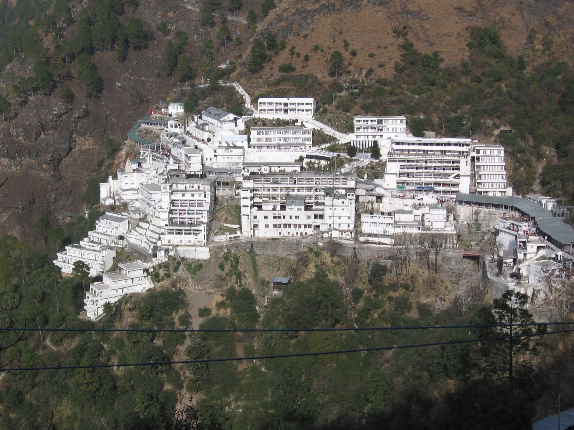
The Vaishno Devi Temple is an important Hindu temple dedicated to Vaishno Devi located in Katra at the Trikuta Mountains within the Indian Union territory of Jammu and Kashmir.[29][30][31] The temple is one of the 108 Shakti Peethas dedicated to Durga, who is worshipped as Vaishno Devi.[32] It is one of the most visited pilgrimage centers of India. Every year millions of visitors visit the temple.[33][34] During festivals like Navaratri, the count even increases to one crore visitors.[35] Shri Mata Vaishno Devi temple is around 120 km (75 mi) from Kalakote.
Shiv Khori

Shiv Khori, is a famous cave shrines of Hindus devoted to lord Shiva, situated in the Reasi district of Jammu and Kashmir in India. Shiv Khori cave is around 56 km (35 mi) away from Kalakote.
Mangla Mata Temple
Mangla Mata Dev Asthan is located near village Bhawani in Nowshera Tehsil of District Rajouri in a forest area. It is a beautiful cave with the pindies of Mangla Mata. No doubt that the people are visiting every day to this place, but two important melas are also organized during the days of Navratras during the months of April and September, every year. It is said that the people had seen tigers visiting the site during night hours. Apart from the pindies, there are two snakes of stones carved in the cave. It is said that originally, this cave was closed but when the people started coming for darshan of Mata Ji, the cave automatically opened. Apart from main cave, there are two other caves also namely Vaishnoo Cave and Naina Mata Cave. The pindies of Naina Mata are also installed in the cave.[36] This temple is around 61 km (38 mi) away from Kalakote to Nowshera side.
Shahdara Sharief
Shahdara Sharief is the shrine of Baba Ghulam Shah. The shrine is commonly known as Shahdara Sharief and is a popular tourist spot of the Rajouri District.
Ghulam Shah made Shadara his abode for the rest of his life. Over a period of time, this shrine has grown into symbol of communal harmony as Muslims, Hindus and Sikhs visit this place in large numbers, offer prayers and seek blessings of the Pir.[37] Shahdara Sharief is around 61 km (38 mi) away from Kalakote.
Notable people
- Abdul Samad - Indian cricketer
References
- "Thermal Power Plant Kalakote". Wikimapia. Retrieved 20 May 2022.
- "Tehsils in District Rajouri". Rajouri.nic.in. Retrieved 20 May 2022.
- "Sub divisions in District Rajouri". Rajouri.nic.in. Retrieved 20 May 2022.
- "Blocks in District Rajouri". Rajouri.nic.in. Retrieved 20 May 2022.
- "Municipalities in District Rajouri". Rajouri.nic.in. Retrieved 20 May 2022.
- "Constituencies in District Rajouri". Rajouri.nic.in. Retrieved 20 May 2022.
- "Rajouri Economy". Rajouri.nic.in. Retrieved 20 May 2022.
- "Tehsils in District Rajouri". Rajouri.nic.in. Retrieved 20 May 2022.
- "List of all officers in Rajouri district". Rajouri.nic.in. Retrieved 20 May 2022.
- "Sub divisions in District Rajouri". Rajouri.nic.in. Retrieved 20 May 2022.
- "List of all officers in Rajouri district". Rajouri.nic.in. Retrieved 20 May 2022.
- "Blocks in District Rajouri". Rajouri.nic.in. Retrieved 20 May 2022.
- "List of all officers in Rajouri district". Rajouri.nic.in. Retrieved 20 May 2022.
- "Municipalities in District Rajouri". Rajouri.nic.in. Retrieved 20 May 2022.
- "Constituencies in District Rajouri". Rajouri.nic.in. Retrieved 20 May 2022.
- "Jammu Kashmir Article 370: Govt revokes Article 370 from Jammu and Kashmir, bifurcates state into two Union Territories". The Times of India. PTI. 5 August 2019. Archived from the original on 5 August 2019. Retrieved 5 August 2019.
- "Coal Mine at Kalakote". Rajouri. Retrieved 1 April 2020.
- "Kalakote got ADC".
- "Economy of Rajouri".
- "Data Finder".
- "Data Finder".
- "List of colleges under Jammu University" (PDF).
- "List of government schools in Jammu and Kashmir" (PDF).
- "List of private schools in Jammu and Kashmir" (PDF).
- "Manma Mata Temple". Native Planet. Retrieved 1 April 2020.
- "Panjara Fort". Jammu Tourism. Retrieved 19 May 2020.
- "Tatta Pani Spring in Kalakote India". India9. Retrieved 1 April 2020.
- "Coal Mine at Kalakote". Rajouri. Retrieved 1 April 2020.
- Rindani, Kirit (2016). Indian Himalaya: Story of a 100 Visits. Partridge Publishing. p. 47. ISBN 978-1482858860.
- S. S. Negi (1998). Discovering the Himalaya, Volume 1. Indus Publishing. p. 429. ISBN 9788173870798.
- Kuldip Singh Gulia (2007). Mountains of the God. Gyan Publishing House. p. 15. ISBN 9788182054202.
- "Famous Durga temples in India for religiously inclined souls". Times of India. 5 April 2019.
- "Vaishno Devi pilgrim footfall in 2019 lowest in 3 years: Shrine Board". Business Standard. 2 January 2020.
- "Vaishno Devi likely to receive 8.5 mn pilgrims by Dec 31; highest in 5 yrs". Business Standard. 29 December 2018.
- "Vaishno Devi-Bhairav Mandir ropeway service starts from today". Times of India Travel. Retrieved 25 December 2018.
- "Mangla Mata". MyTourMania. Retrieved 1 April 2020.
- "Shahdara Sharief". Rajouri. Retrieved 1 April 2020.
Другой контент может иметь иную лицензию. Перед использованием материалов сайта WikiSort.org внимательно изучите правила лицензирования конкретных элементов наполнения сайта.
WikiSort.org - проект по пересортировке и дополнению контента Википедии