world.wikisort.org - India
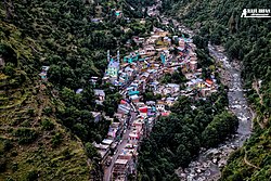
Kahara is a village and tehsil in Doda district, Jammu, India. It is situated between mountainous cliffs 13 kilometres (8.1 mi) from Thathri on Thathri-Gandoh road.[1]
Kahara | |
|---|---|
Village/tehsil | |
 | |
 Kahara Kahara in Jammu and Kashmir, India | |
| Coordinates: 33.093°N 75.870°E | |
| Country | India |
| Union Territory | Jammu and Kashmir |
| District | Doda |
| Area | |
| • Total | 1.50 km2 (0.58 sq mi) |
| Demonym(s) | Kashmiri, Bhalessi, Bhaderwahi, Sarazi, Gojri, Bhalessi |
| Languages | |
| • Official Language | Urdu |
| • Spoken | Kashmiri, Gojari, Bhadarwahi, Urdu |
| Time zone | UTC+5:30 (IST) |
| PIN | 182203 |
| DDC Member | Mehraj Din Malik (Aam Aadmi Party) |
Geography
Kahara is a hilly area in the Doda district, with several villages including Joura Kalan, Joura Khurd, Budhi, Kunthal, Shamdlian, Jia Halaran, Halaran, Kencha, Tanta, Malanoo, and Batogra.[2]
Kahara was part of Thathri tehsil as a block. It was separated as a new tehsil in 2014, and now it is part of the subdivision Thathri.[3]
Kahara is located 13 kilometres (8.1 mi) from Thathri on the Thathri-Gandoh road, which links with National Highway 244 at Thathri.[4]
Politics
Mehraj Malik is the District Development Council (DDC) Councilor from the Kahara constituency.[5]
Notable people
References
- Kichloo, Muzaffar and Kumar, Sudesh and Sharma, Neeraj (June 2020). "Breeding site records of three sympatric vultures in a mountainous cliff in Kahara-Thathri, Jammu & Kashmir, India". Journal of Threatened Taxa. 12 (9): 16166–16169. doi:10.11609/jott.5537.12.9.16166-16169. Retrieved 21 July 2020.
{{cite journal}}: CS1 maint: multiple names: authors list (link) - "Save Forests, villagers appeal minister". JK Monitor. 24 April 2016. Retrieved 21 July 2020.
- "TDF demands Delimitation of Assembly seats before Assembly elections". The Northern Herald. 17 November 2019. Retrieved 21 July 2020.
- "Dilapidated condition of Thathri-Gandoh road irks people". Daily Excelsior. 20 May 2020. Retrieved 21 July 2020.
- "J&K DDC Polls: Contesting as Independent, AAP leader from Doda scores first win for party". The Free Press Journal. 23 Dec 2020. Retrieved 29 March 2022.
- "Ghulam Nabi Azad condoles Bashir Ahmed Sirwal demise". KNS Kashmir. 26 May 2020. Retrieved 20 July 2020.
- "Azad condoles demise of Sirwal". Greater Kashmir. 27 May 2020. Retrieved 21 July 2020.
Текст в блоке "Читать" взят с сайта "Википедия" и доступен по лицензии Creative Commons Attribution-ShareAlike; в отдельных случаях могут действовать дополнительные условия.
Другой контент может иметь иную лицензию. Перед использованием материалов сайта WikiSort.org внимательно изучите правила лицензирования конкретных элементов наполнения сайта.
Другой контент может иметь иную лицензию. Перед использованием материалов сайта WikiSort.org внимательно изучите правила лицензирования конкретных элементов наполнения сайта.
2019-2025
WikiSort.org - проект по пересортировке и дополнению контента Википедии
WikiSort.org - проект по пересортировке и дополнению контента Википедии