world.wikisort.org - India
Joshimath, also known as Jyotirmath, is a city and a municipal board in Chamoli District in the Indian state of Uttarakhand. Located at a height of 6150 feet (1875 m),[2] it is a gateway to several Himalayan mountain climbing expeditions, trekking trails and pilgrim centres like Badrinath.[3] It is home to one of the four cardinal pīthas established by Adi Shankara.[4] Since 7 February 2021, the area was severely efected by the 2021 Uttarakhand flood and its aftermath.
This article cites its sources but does not provide page references. (September 2010) |
Jyotirmath
Jyotirmath | |
|---|---|
city | |
View of Jyotirmath from Narsingh Temple | |
 Jyotirmath Location in Uttarakhand, India  Jyotirmath Jyotirmath (India) | |
| Coordinates: 30.57°N 79.57°E | |
| Country | |
| State | |
| District | Chamoli |
| Tehsil | Jyotirmath |
| Population (2011) | |
| • Total | 16,709 |
| Languages | |
| • Official | Garhwali , Hindi |
| Time zone | UTC+5:30 (IST) |
| PIN | 246443[1] |
| Vehicle registration | UK-11 |
| Website | http://chamoli.nic.in |
History
Between 7th and 11th centuries C.E., Katyuri kings, ruled the area of varying extent from their capital at "Katyur" (modern day Baijnath) valley in Kumaon. The Katyuri dynasty was founded by Vashudev Katyuri. The ancient Basdeo temple at Joshimath is attributed to Vasu Dev.[5] Vasu Dev was of Buddhist origin, but later followed Brahminical practices and the brahminical practices of Katyuri kings in general is sometimes attributed to a vigorous campaign of Adi Shankara (788-820 CE).[5]
Katyuri kings were displaced by the Panwar dynasty in the 11th century AD.[5]
2021 glacial outburst flood
A part of the Nanda Devi glacier breaks off in Nanda Devi National Park in Uttarakhand's Chamoli district on 7 February 2021, causing flash flood in Rishiganga and Dhauliganga River, devastating among others the village Rini, the Dhauliganga Dam, the Rishi Ganga dam, Tapovan Vishnugad Hydropower Plant, killing and endangering people, according to media. At least 31 people are confirmed to have been killed and around 165 were reported missing after the flash flood. A PTI report put the number of workers missing at 150.
Demographics
As of 2011[update] India census, there are total 3,898 families residing in the Joshimath city. The total population of Joshimath is 16,709 out of which 9,988 are males and 6,721 are females. Thus the Average Sex Ratio of Joshimath is 673.[6][7]
The population of Children of age 0–6 years in Joshimath city is 2103 which is 13% of the total population. There are 1127 male children and 976 female children between the age 0–6 years. Thus as per the Census 2011 the Child Sex Ratio of Joshimath is 866 which is greater than Average Sex Ratio (673).[6][7]
As per the Census 2011, the literacy rate of Joshimath is 91.3% up from 77% in 2001. Thus Joshimath has a higher literacy rate compared to the 82.7% of its own district, Chamoli. The male literacy rate is 84.5% and the female literacy rate is 72.8% in Joshimath.[6][7]
Joshimath had a population of 13,202 in 2001.[8]
Religious significance

Jyotirmath is the uttarāmnāya matha, or northern monastery, one of the four cardinal institutions established by Adi Shankara, the others being those at Shringeri, Puri and Dwarka. Their heads are titled "Shankaracharya". According to the tradition initiated by Adi Shankara, this matha is in charge of the Atharvaveda. Jyotirmath is close to the pilgrimage town of Badrinath. This place can be a base station for travellers going to Guru Gobind Ghat or the Valley of Flowers National Park. The temple Narasimha, is enshrined Badrinarayan along with a pantheon of deities. The presiding deity Lord Narasimha is believed to have been established by Adi Sankara. It is one of the "Divya Desams", the 108 temples of Vishnu revered by the 12 Tamil poet-saints or Alvars, and god and goddess are known as Parimalavalli sametha Paramapurusha Perumal .[9]
Joshimath Cantonment
Joshimath Cantonment is one of the important military stations of Indian Army, present in Uttarakhand. It is the permanent station of "The Garhwal Scouts", the scout battalion of the Garhwal Rifles. It is the closest army station to the Indo-Tibetan Border. It was used as a base camp for the rescue of the victims of 2013 Kedarnath Floods.
Tourist attractions
Shankaracharya Math
This is the math established by Adi Shankaracharya in North India. The math has temples of Badrinarayan and Rajrajeshwari Devi. It has a sacred cave where Adi Shankaracharya supposedly undertook tapasya.
Narsingh Temple
This is an ancient temple of Lord Vishnu in Narsingh Avtar and main temple of Joshimath. It has an idol of Lord Narsingh, which is considered established by Shankaracharya. As per local belief, the right hand of this idol has become as thin as hair. On the day when it will break, the mountains Jay-Vijay (which are situated on a way to Badrinath) shall join and become one and Lord Badrinath of Badrinath temple will disappear from the present temple and re-appear as black stone (Shaligram) at new place called Bhavishya Badri, which is situated at a distance of 10 km from Joshimath. During the period when Badrinath temple remains closed during winter every year, an idol of Lord Badri is brought to Narsinh temple and worshiped for six months.[10]
Bhavishya Kedar Temple
As per local belief, present Kedarnath will disappear along with Badrinath and re-appear in Bhavishya Kedar temple at Joshimath. This temple has a small shivling.
Tapovan

Tapovan is situated 10 km from Joshimath. It has natural hot water springs. The river Dhauliganga is visible from this spot.
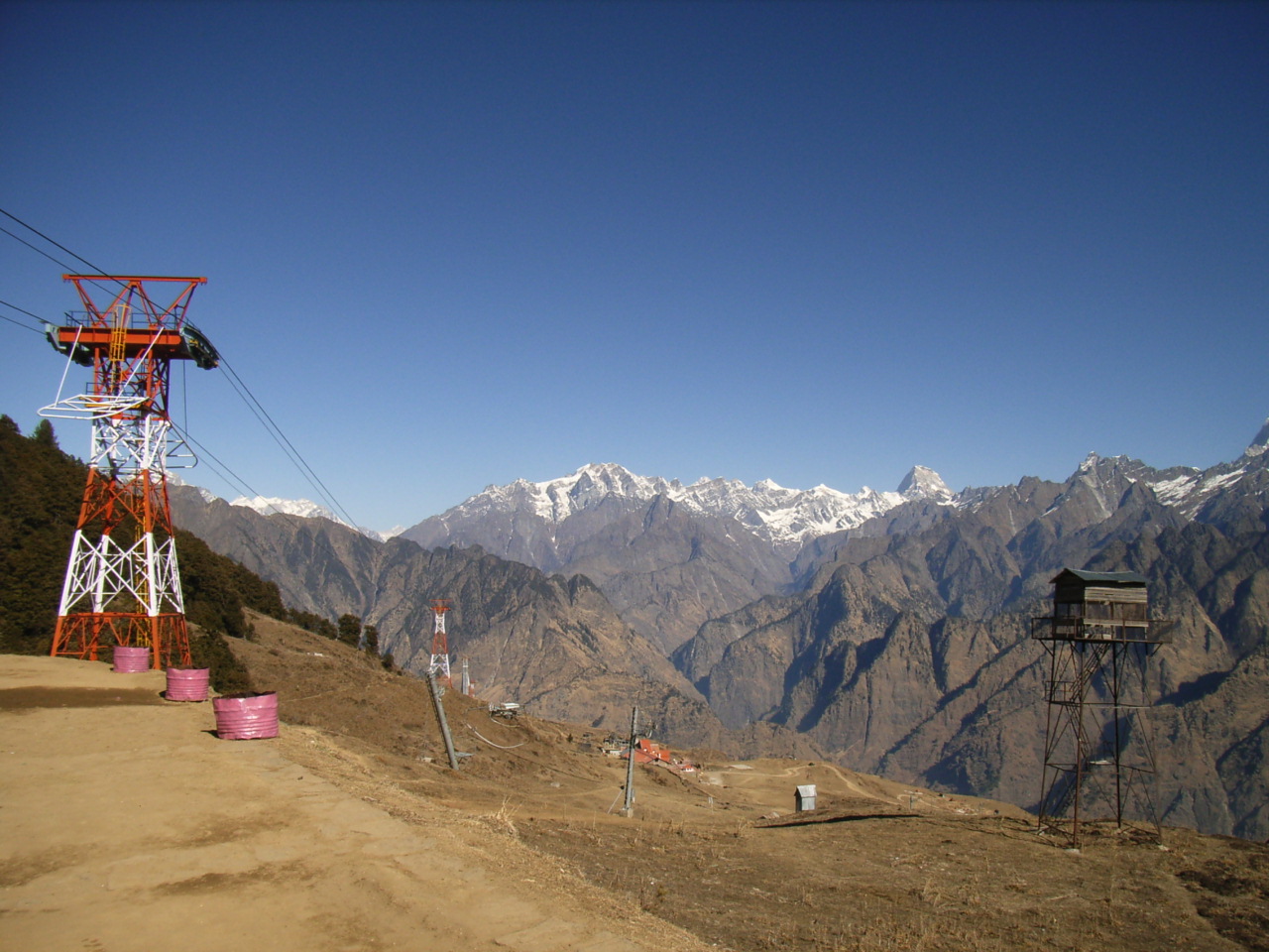
Ropeway
A ropeway to Auli is popular among tourists and one of the longest ropeways in Asia. It is open only during the winter season (November to March) and costs Rs 1000 for two way journey. The ropeway is the fastest means for tourists to go to Auli.
Gari Bhawani Temple
A temple is located 6 km away from the main town of Joshimath toward Rishikesh highway.
Kalpeshwer
Kalpeshwar is situated near the village called Urgam, which is located in a valley. Urgam is off the highway NH-58 and is reached from Helang which is situated at about 18 km from Joshimath. There are sometimes shared vans from Helang to Nyari/Urgam before noon. Public bus transportation is available everyday from Joshimath to Helang from 5AM to 7PM.
Climate
| Climate data for Jyotirmath (1971–2000, extremes 1958–1987) | |||||||||||||
|---|---|---|---|---|---|---|---|---|---|---|---|---|---|
| Month | Jan | Feb | Mar | Apr | May | Jun | Jul | Aug | Sep | Oct | Nov | Dec | Year |
| Record high °C (°F) | 21.6 (70.9) |
21.1 (70.0) |
28.6 (83.5) |
30.6 (87.1) |
31.9 (89.4) |
34.2 (93.6) |
30.2 (86.4) |
29.9 (85.8) |
30.0 (86.0) |
28.0 (82.4) |
25.1 (77.2) |
21.2 (70.2) |
34.2 (93.6) |
| Average high °C (°F) | 11.0 (51.8) |
11.8 (53.2) |
17.3 (63.1) |
21.3 (70.3) |
23.5 (74.3) |
24.8 (76.6) |
23.3 (73.9) |
23.0 (73.4) |
22.3 (72.1) |
22.0 (71.6) |
16.9 (62.4) |
13.4 (56.1) |
19.1 (66.4) |
| Average low °C (°F) | 2.0 (35.6) |
3.0 (37.4) |
6.7 (44.1) |
10.7 (51.3) |
13.6 (56.5) |
16.3 (61.3) |
16.9 (62.4) |
16.6 (61.9) |
14.5 (58.1) |
10.7 (51.3) |
6.7 (44.1) |
3.9 (39.0) |
9.9 (49.8) |
| Record low °C (°F) | −15.1 (4.8) |
−4.3 (24.3) |
−4.0 (24.8) |
0.0 (32.0) |
4.9 (40.8) |
6.0 (42.8) |
10.0 (50.0) |
12.6 (54.7) |
8.0 (46.4) |
1.8 (35.2) |
0.1 (32.2) |
−3.1 (26.4) |
−15.1 (4.8) |
| Average rainfall mm (inches) | 57.1 (2.25) |
93.5 (3.68) |
118.7 (4.67) |
51.3 (2.02) |
72.9 (2.87) |
93.3 (3.67) |
224.6 (8.84) |
201.6 (7.94) |
111.1 (4.37) |
43.2 (1.70) |
10.2 (0.40) |
26.8 (1.06) |
1,104.1 (43.47) |
| Average rainy days | 3.8 | 5.7 | 7.4 | 4.1 | 6.0 | 7.5 | 15.4 | 15.3 | 9.1 | 2.9 | 1.0 | 1.6 | 79.7 |
| Average relative humidity (%) (at 17:30 IST) | 55 | 52 | 52 | 51 | 51 | 62 | 79 | 80 | 73 | 59 | 50 | 53 | 60 |
| Source: India Meteorological Department[11][12] | |||||||||||||
Transportation
The nearest airport is the Jolly Grant Airport near Dehradun 293 km (182 mi) away.
The nearest railway station is at Rishikesh, which has a small railway terminal. Haridwar railway junction, 24 km farther from Rishikesh, has train connections to most of the major cities in India.
Joshimath lies on national highway NH58 that connects Delhi with Badrinath and Mana Pass in Uttarakhand near the Indo-Tibet border. Therefore, all the buses and vehicles that carry pilgrims from New Delhi to Badrinath via Haridwar and Rishikesh in the pilgrim season of the summer months pass through Joshimath. Rishikesh is the major starting point for a road journey to Joshimath. Regular buses operate from Rishikesh bus station to Joshimath. The road distance from Rishikesh to Joshimath is 251 km (156 mi) via Rudraprayag and Chamoli.
See also
- Adi Shankara
- Shankaracharya
- Kalady, Kerala - the holy birthplace of Jagadguru Adi Shankaracharya
- Govardhan Peetham (East), Puri, Odisha
- Dwarka Sharada Peetham (West), Dwarka, Gujarat
- Shri Sringeri Sharada Peetham (South), Sringeri, Karnataka
- Shri Kanchi Kamakoti Peetham, Kancheepuram, Tamil Nadu
- Gauḍapāda
- Govinda Bhagavatpada
- Shri Gaudapadacharya Math
- Mandukya Upanishad
- Advaita Vedanta
References
- "Joshimath Pin code". pin-code.net. Retrieved 8 July 2021.
- Singh, V.P. Flt.Lt. "Himalayan Journal 1967-68". The Himalayan Club. Retrieved 6 June 2013.
- Agarwal, Meena. "The Ascent of Trisul, 1970". The Himalayan Club. Retrieved 6 June 2013.
- "Jyotirmath". Retrieved 26 February 2015.
- O.C.Handa, 2002, History of Uttaranchal, Indus Publishing Company. ISBN 9788173871344.
- "Joshimath Population, Caste Data Chamoli Uttarakhand - Census India". www.censusindia.co.in. Retrieved 5 May 2017.
- "Joshimath City Population Census 2011 - Uttarakhand". www.census2011.co.in. Retrieved 5 May 2017.
- "Census of India 2001: Data from the 2001 Census, including cities, villages and towns (Provisional)". Census Commission of India. Archived from the original on 16 June 2004. Retrieved 1 November 2008.
- 108 Vaishnavite Divya Desams: Divya desams in Pandya Nadu. M. S. Ramesh, Tirumalai-Tirupati Devasthanam.
- "Bhavishya Badri | Chamoli District Website | India". Retrieved 19 February 2021.
- "Station: Joshimath Climatological Table 1971–2000" (PDF). Climatological Normals 1971–2000. India Meteorological Department. October 2011. pp. 367–368. Archived from the original (PDF) on 15 February 2020. Retrieved 31 March 2020.
- "Extremes of Temperature & Rainfall for Indian Stations (Up to 2012)" (PDF). India Meteorological Department. December 2016. p. M225. Archived from the original (PDF) on 5 February 2020. Retrieved 31 March 2020.
External links
 Joshimath travel guide from Wikivoyage
- Joshimath Portal
Śaṃkara Maṭhas | ||
|---|---|---|
| ||
На других языках
[de] Jyotirmath
Jyotirmath oder auch Joshimath ist eine Kleinstadt im Distrikt Chamoli im indischen Bundesstaat Uttarakhand.- [en] Joshimath
Другой контент может иметь иную лицензию. Перед использованием материалов сайта WikiSort.org внимательно изучите правила лицензирования конкретных элементов наполнения сайта.
WikiSort.org - проект по пересортировке и дополнению контента Википедии