world.wikisort.org - India
Guthani is a community development block and a revenue circle in Siwan district of the Indian state of Bihar, lying on the banks of river Chhoti Gandak. It is one out of 13 blocks of Siwan Subdivision. The headquarter of the block is at Guthani town (Nagar Panchayat Guthani). The block is divided into Ten Gram Panchayats (Rural Area) and one city council, Nagar Panchayat Guthani (urban area).
Guthani | |
|---|---|
CD Block | |
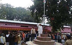
 Flag Hosting in Guthani Block | |
 Guthani Location in Bihar, India | |
| Coordinates: 26.1636°N 84.0364°E | |
| Country | India |
| State | Bihar |
| District | Siwan |
| Subdivision | Siwan |
| Headquarters | Guthani Block and Circle Office |
| Government | |
| • Type | Community development |
| • Body | Guthani Block and Circle |
| Area | |
| • Total | 91.70 km2 (35.41 sq mi) |
| Elevation | 73 m (240 ft) |
| Population (2011) | |
| • Total | 128,155 |
| • Density | 1,400/km2 (3,600/sq mi) |
| Language | |
| • Official | Hindi[1] |
| • Additional official | Urdu[1] |
| • Regional | Bhojpuri |
| Time zone | UTC+5:30 (IST) |
| PIN | 841435 |
| Telephone code | 06157 |
| Vehicle registration | BR-29 |
| Sex ratio | 1000:994 Male/Female |
| Lok Sabha constituency | Siwan |
| Vidhan Sabha constituency | Darauli |
Total area of the block is 91.70 square kilometres (35.41 sq mi) and the total population of the block as of 2011 census of India is 128,155.[2]
Gram Panchayats
Gram panchayats of Guthani block in Siwan Subdivision, Siwan district.[3]
- Balua
- Barpalia
- Belaur
- Biswar
- Chitakhal
- Jataur
- Parari
- Sohagara
- Sonahula
- Tarawa khurd
See also
Nagar Panchayat Guthani (City council)
- Siwan Subdivision
- Administration in Bihar
References
- "52nd REPORT OF THE COMMISSIONER FOR LINGUISTIC MINORITIES IN INDIA" (PDF). nclm.nic.in. Ministry of Minority Affairs. Archived from the original (PDF) on 25 May 2017. Retrieved 9 October 2019.
- "DISTRICT CENSUS HANDBOOK - Census of India" (PDF). www.censusindia.gov.in. Retrieved 3 July 2018.
- "Village & Panchayats". www.siwan.nic.in. Retrieved 3 July 2018.
Текст в блоке "Читать" взят с сайта "Википедия" и доступен по лицензии Creative Commons Attribution-ShareAlike; в отдельных случаях могут действовать дополнительные условия.
Другой контент может иметь иную лицензию. Перед использованием материалов сайта WikiSort.org внимательно изучите правила лицензирования конкретных элементов наполнения сайта.
Другой контент может иметь иную лицензию. Перед использованием материалов сайта WikiSort.org внимательно изучите правила лицензирования конкретных элементов наполнения сайта.
2019-2025
WikiSort.org - проект по пересортировке и дополнению контента Википедии
WikiSort.org - проект по пересортировке и дополнению контента Википедии
