world.wikisort.org - India
Gangasagar is a village and a gram panchayat within the jurisdiction of the Sagar police station in the Sagar CD block in the Kakdwip subdivision of the South 24 Parganas district in the Indian state of West Bengal.
Gangasagar | |
|---|---|
Village | |
 Kapil Muni Ashram | |
 Gangasagar Location in West Bengal  Gangasagar Location in India | |
| Coordinates: 21.6528°N 88.0753°E | |
| Country | |
| State | |
| District | South 24 Parganas |
| CD Block | Sagar |
| Area | |
| • Total | 12.26 km2 (4.73 sq mi) |
| Elevation | 4 m (13 ft) |
| Population (2011) | |
| • Total | 10,340 |
| • Density | 840/km2 (2,200/sq mi) |
| Languages | |
| • Official | Bengali[1][2] |
| • Additional official | English[1] |
| Time zone | UTC+5:30 (IST) |
| PIN | 743606 |
| Telephone code | +91 3210 |
| Vehicle registration | WB-19 to WB-22, WB-95 to WB-99 |
| Lok Sabha constituency | Mathurapur (SC) |
| Vidhan Sabha constituency | Sagar |
| Website | www |
Mythological significance

A holy man, Kardam Muni, made a pact with Vishnu that he would undergo the rigours of marital life, on the condition that Vishnu would incarnate as his son. In due time Kapil Muni was born as an incarnation of Vishnu and became a great saint. Kapil Muni's ashram was located in the Gangasagar. One day King Sagar's sacrificial horse disappeared; it had been stolen by Indra.
The king sent his 60,000 sons to find it, and they found it next to Kapil Muni's ashram, where Indra had hidden it. Mistaking Kapil Muni for the thief, the sons accused Kapil Muni, who in his wrath at the false accusation burned the sons to ash and sent their souls to Hell. Later having compassion for the King Sagar's sons, Kapil Muni acceded to the prayers of King Sagar's descendants, agreeing to the restoration of the sons, if river goddess Ganga would descend to Earth to perform the Last Ritual (Hindus also called as"Tarpan") of mixing the ashes with holy water (niravapanjali).
Through deep meditation, King Bhagiratha induced Shiva to order Ganga down from heaven and the 60,000 sons were freed (moksha) and ascended to Heaven, but the river Ganges stayed on the Earth. The date of the descent of Ganga was the date, as is at present the 15th Day of January of the Gregorian Calendar which coincides with that of Makar Sankranti (when Surya enters Makar Constellation, i.e. "Uttarayan" of Hindu Panchangam).[3][4]
Geography
R: rural/ urban centre
Places linked with coastal activity are marked in blue
Owing to space constraints in the small map, the actual locations in a larger map may vary slightly
Area overview
Kakdwip subdivision has full rural population. The entire district is situated in the Ganges Delta. The southern part of the delta has numerous channels and islands such as the Henry Island, Sagar Island, Frederick Island and Fraserganj Island. The subdivision is a part of the Sundarbans settlements. A comparatively recent country-wide development is the guarding of the coastal areas by special coastal forces. The area attracts large number of tourists – Gangasagar and Fraserganj-Bakkhali are worth mentioning. Gobardhanpur holds a promise for the future.[5][6][7]
Note: The map alongside presents some of the notable locations in the subdivision. All places marked in the map are linked in the larger full screen map.
Location

Gangasagar is located at 21°39′10″N 88°04′31″E. It has an average elevation of 4 metres (13 ft).
Climate
| Climate data for Gangasagar (1981–2010, extremes 1865–2010) | |||||||||||||
|---|---|---|---|---|---|---|---|---|---|---|---|---|---|
| Month | Jan | Feb | Mar | Apr | May | Jun | Jul | Aug | Sep | Oct | Nov | Dec | Year |
| Record high °C (°F) | 30.6 (87.1) |
33.9 (93.0) |
38.3 (100.9) |
39.4 (102.9) |
38.7 (101.7) |
40.0 (104.0) |
36.1 (97.0) |
36.7 (98.1) |
36.1 (97.0) |
34.0 (93.2) |
32.9 (91.2) |
32.9 (91.2) |
40.0 (104.0) |
| Average high °C (°F) | 25.0 (77.0) |
27.2 (81.0) |
30.0 (86.0) |
31.6 (88.9) |
32.5 (90.5) |
31.8 (89.2) |
30.8 (87.4) |
30.9 (87.6) |
31.1 (88.0) |
31.0 (87.8) |
29.0 (84.2) |
25.9 (78.6) |
29.7 (85.5) |
| Average low °C (°F) | 16.0 (60.8) |
19.8 (67.6) |
23.9 (75.0) |
25.9 (78.6) |
26.7 (80.1) |
27.1 (80.8) |
26.8 (80.2) |
26.5 (79.7) |
26.4 (79.5) |
24.9 (76.8) |
21.2 (70.2) |
17.4 (63.3) |
23.6 (74.5) |
| Record low °C (°F) | 7.8 (46.0) |
7.2 (45.0) |
12.2 (54.0) |
12.9 (55.2) |
17.5 (63.5) |
18.0 (64.4) |
16.2 (61.2) |
16.4 (61.5) |
17.6 (63.7) |
17.2 (63.0) |
12.2 (54.0) |
9.4 (48.9) |
7.2 (45.0) |
| Average rainfall mm (inches) | 12.5 (0.49) |
24.8 (0.98) |
17.3 (0.68) |
46.2 (1.82) |
144.9 (5.70) |
303.9 (11.96) |
319.9 (12.59) |
345.7 (13.61) |
319.2 (12.57) |
195.7 (7.70) |
53.3 (2.10) |
3.6 (0.14) |
1,787.1 (70.36) |
| Average rainy days | 0.9 | 1.5 | 1.6 | 2.5 | 6.1 | 10.7 | 13.6 | 15.4 | 11.7 | 6.7 | 1.7 | 0.3 | 72.7 |
| Average relative humidity (%) (at 17:30 IST) | 70 | 73 | 76 | 81 | 81 | 83 | 85 | 84 | 83 | 77 | 72 | 69 | 78 |
| Source: India Meteorological Department[8] | |||||||||||||
Demographics
According to the 2011 Census of India, Gangasagar had a total population of 10,340, of which 5,228 (51%) were males and 5,112 (49%) were females. There were 1,440 persons in the age range of 0 to 6 years. The total number of literate people in Gangasagar was 7,437 (83.56% of the population over 6 years).[9]
Civic administration
Police station
Gangasagar Coastal police station covers an area of 77.72 km2. It has jurisdiction over parts of the Sagar CD block. The coastal police stations were formed with the objective of effective policing of the remote areas of the Sundarbans. The police has regular river patrols.[10][11]
Culture
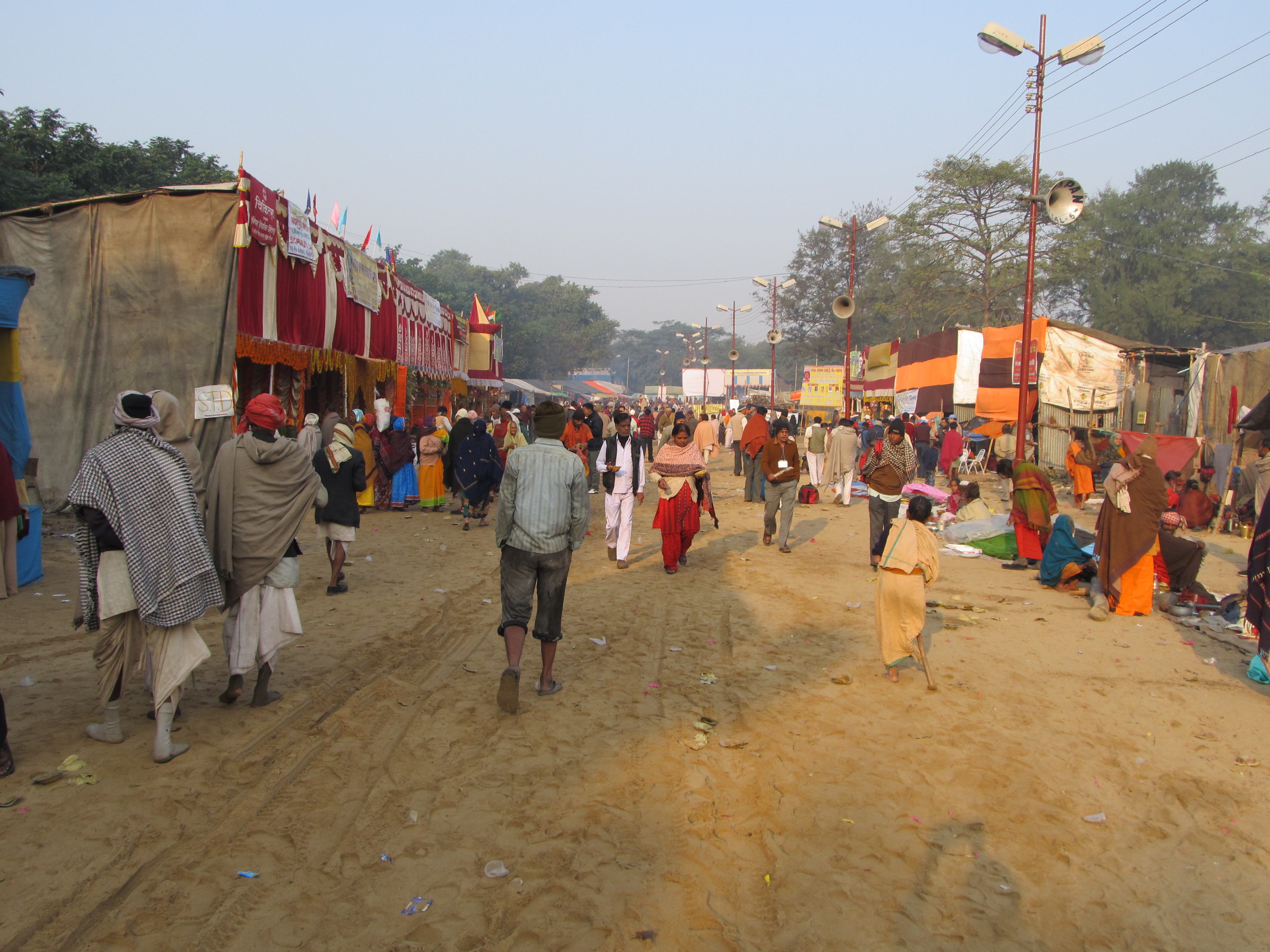
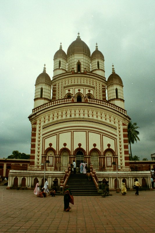
Gangasagar is a place of Hindu pilgrimage. Every year on the day of Makar Sankranti (14 January), hundreds of thousands of Hindus gather to take a holy dip at the confluence of river Ganges and Bay of Bengal and offer prayers (puja) in the Kapil Muni Temple.[3]
The Gangasagar fair and pilgrimage is held annually on Sagar Island's southern tip, where the Ganges enters the Bay of Bengal.[12] This confluence is also called Gangasagar or Gangasagara.[13] Near the confluence is the Kapil Muni Temple.[13] The Gangasagar pilgrimage and fair is the second largest congregation of mankind after the triennial ritual bathing of Kumbha Mela.[14]
In 2007, about 300,000 pilgrims took the holy dip where the Hooghly meets the Bay of Bengal on the occasion of Makar Sankranti. Almost five-hundred thousand pilgrims thronged Gangasagar in 2008.[15] For the rest of the year about 500,000 people come to the island.[16] According to reports on 14 January 2018, 18-2 million people had visited Gangasagar in 2018, against 1.5 million in 2017.[17]
Transport

From Kolkata, Diamond Harbour Road (NH-12) runs south around 90 km to Harwood Point, near Kakdwip, where a ferry runs to Kachuberia at the north end of the Gangasagar.[18] The Panchyat Samity maintains a parking area near the ferry landing. The ferry travels about 3.5 km across a distributary of the Ganges river (also known as Hooghly River or Muriganga river locally) to reach Kachuberia. Small boats also cross from Harwood Point to Kachuberia. Private cars and buses travel the roughly 32 km to the pilgrimage site at Gangasagar.[13] From the pilgrimage parking area the Kapil Muni Temple is about 200 meters and the Gangasagar confluence is about 700 meters.
Healthcare
There is a primary health centre at Gangasagar, with 6 beds.[19]
References
- "Fact and Figures". Wb.gov.in. Retrieved 5 July 2019.
- "52nd Report of the Commissioner for Linguistic Minorities in India" (PDF). Nclm.nic.in. Ministry of Minority Affairs. p. 85. Archived from the original (PDF) on 25 May 2017. Retrieved 5 July 2019.
- Dasgupta, Samira; Mondal, Krishna & Basu, Krishna (2006). "Dissemination of Cultural Heritage and Impact of Pilgrim Tourism at Gangasagar Island" (PDF). Anthropologist. 8 (1): 11–15. doi:10.1080/09720073.2006.11890928. S2CID 147750124. Archived (PDF) from the original on 1 November 2006.
- The Mahabharata translated by Kisari Mohan Ganguli (1883 -1896), Book 3: Vana Parva: Tirtha-yatra Parva: Section 107, Section 108 and Section 109.
- "District Statistical Handbook 2014 South Twety-four Parganas". Table 2.1 , 2.2, 2.4b. Department of Statistics and Programme Implementation, Government of West Bengal. Retrieved 5 December 2019.
- "Census of India 2011, West Bengal, District Census Handbook, South Twentyfour Parganas, Series – 20, Part XII-A, Village and Town Directory" (PDF). Page 13, Physigraphy. Directorate of Census Operations, West Bengal. Retrieved 5 December 2019.
- "District Human Development Report: South 24 Parganas". Chapter 9: Sundarbans and the Remote Islanders, p 290-311. Development & Planning Department, Government of West Bengal, 2009. Archived from the original on 5 October 2016. Retrieved 5 December 2019.
- "Station: Gangasagar (Sagar Island) Climatological Table 1981–2010" (PDF). Climatological Normals 1981–2010. India Meteorological Department. January 2015. pp. 677–678. Archived from the original (PDF) on 5 February 2020. Retrieved 18 January 2021.
- "C.D. Block Wise Primary Census Abstract Data(PCA)". West Bengal – District-wise CD Blocks. Registrar General and Census Commissioner, India. Retrieved 24 October 2019.
- "Sagar Police Station". Sundarban police district. West Bengal police. Archived from the original on 20 October 2019. Retrieved 24 October 2019.
- "District Statistical Handbook 2014 South 24 Parganas". Table No. 2.1. Department of Statistics and Programme Implementation, Government of West Bengal. Retrieved 24 October 2019.
- "Makar Sankanti festival: Sun's Transition from Sagittarius to Capricorn: Time to visit Gangasagar". Press Information Bureau, Government of India. Archived from the original on 30 September 2007.
- Abram, David, ed. (2011). "Chapter J: Kolkata and West Bengal". The Rough Guide to India. Penguin. p. 766. ISBN 978-1-4053-8583-1.
- Dawar, Damini (14 January 2014). "Ganga Sagar Mela in West Bengal : A dip for Moksha". Merinews. Archived from the original on 16 January 2014.
- "Dip, deaths mark Sagar mela finale". The Statesman, 16 January 2008. Retrieved 16 January 2008.
- Chattopdhyay, Debashis (15 January 2007). "Bridge plea for Sagar tourism". The Telegraph. Calcutta, India. Archived from the original on 2007.
- "West Bengal: On Makar Sankranti 2018, Ganga Sagar Mela witnesses record crowds". Home>>India. DNA, 14 January 2018. 14 January 2018. Retrieved 16 January 2018.
- Bindloss, Joseph; et al. (2009). Northeast India. Footscray, Victoria, Australia: Lonely Planet. p. 141. ISBN 978-1-74179-319-2.
- "Health & Family Welfare Department" (PDF). Health Statistics – Primary Health Centres. Government of West Bengal. Retrieved 11 November 2019.
External links
Hindu Temples in West Bengal | ||
|---|---|---|
| Bankura |
|  |
| Cooch Behar |
| |
| Darjeeling |
| |
| Hooghly |
| |
| Howrah |
| |
| Kolkata |
| |
| Murshidabad |
| |
| Nadia |
| |
| North 24 Parganas |
| |
| Paschim Bardhaman |
| |
| Purba Bardhaman |
| |
| Paschim Medinipur |
| |
| Purba Medinipur |
| |
| Purulia |
| |
| South 24 Parganas |
| |
| See also | Temple towns in West Bengal | |
Другой контент может иметь иную лицензию. Перед использованием материалов сайта WikiSort.org внимательно изучите правила лицензирования конкретных элементов наполнения сайта.
WikiSort.org - проект по пересортировке и дополнению контента Википедии