world.wikisort.org - India
Chadiapada is a small village in Ganjam district of Odisha, India.
This article includes a list of general references, but it lacks sufficient corresponding inline citations. (January 2014) |
Chadiapada | |
|---|---|
Village | |
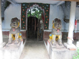 ଠାକୁରାଣୀ ମନ୍ଦିର | |
 Chadiapada | |
| Coordinates: 19.6816266°N 84.7952056°E | |
| Country | |
| State | Odisha |
| District | Ganjam |
| Block | Polasara |
| Gram Panchayat | Khanduru |
| Population (2011) | |
| • Total | 1,001 |
| Language | |
| • Official | Oriya |
| Time zone | IST |
| PIN | 761105 |
Geography
Chadiapada is located at 19.6816266°N 84.7952056°E.[1] It has an average elevation of 61 meters (200 feet). It is situated at 67 km from Brahmapur on North, 3 km from Polasara on the South-West. Polasara - Asika road passes through this village.
Demographics
- As of 2011[update] India census,[2] Chadiapada had 243 households with a population of 1,001. Males constitute 48.05% (481) of the population and females 51.95% (520). Chadiapada had an average literacy rate of 62%, lower than the national average of 64.8%: male literacy is 70.47%, and female literacy is 54.2%. In Chadiapada, 14% of the population is under 6 years of age.
- As of 2001[update] India census,[3] Chadiapada had 213 households with a population of 994. Males constitute 49% (484) of the population and females 51% (510).
Temples
- Nilakantheshwara Mandira
- Kanaka Durga Mandira or Panchu Deula
- Gundicha Mandira
- Gramadevi Mandira
- Thakurani Mandira
Education
Chadiapada has two Upper Primary Schools and one Middle English School.
- Chadiapada Krushnadaspur Sasan Upper Primary School
- Deulapalli Upper Primary School
- Kanaka Durga Middle English School
Economy
Most people of this village are farmers and textile mill workers in Surat. A few are government and private sector employees. Most of the Brahmins of this village perform priestly services.
Transport
The nearest town is Polasara (around 155 km from state capital Bhubaneswar). It is well connected by road with various cities and towns like Bhubaneswar, Asika, Berhampur and Buguda. Frequent bus services are available to all the above cities.[citation needed]
References
- Falling Rain Genomics, Inc - Polasara
- "Census of India 2011: View Population Details - Chadhiapadakrushnadaspur". Census Commission of India. Archived from the original on 18 August 2016.
- "Census of India 2001: View Population Details - Chadhiapadakrushnadaspur".
This article about a location in Ganjam district, Odisha, India is a stub. You can help Wikipedia by expanding it. |
Другой контент может иметь иную лицензию. Перед использованием материалов сайта WikiSort.org внимательно изучите правила лицензирования конкретных элементов наполнения сайта.
WikiSort.org - проект по пересортировке и дополнению контента Википедии