world.wikisort.org - India
Budampadu is a neighbourhood of Guntur in the Indian state of Andhra Pradesh.[2] It was merged in Guntur Municipal Corporation in 2012 and is a part of Guntur East mandal (formerly Guntur mandal).[3][4]
Budampadu | |
|---|---|
Neighborhood | |
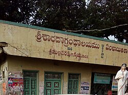
 Sri Sarada Library, Budampadu | |
 Budampadu Location in Andhra Pradesh, India | |
| Coordinates: 16.2593°N 80.4756°E | |
| Country | India |
| State | Andhra Pradesh |
| District | Guntur |
| City | Guntur |
| Area | |
| • Total | 10.21 km2 (3.94 sq mi) |
| Population (2011)[1] | |
| • Total | 4,959 |
| • Density | 490/km2 (1,300/sq mi) |
| Languages | |
| • Official | Telugu |
| Time zone | UTC+5:30 (IST) |
| PIN | 522017 |
| Vehicle registration | AP |
Transport
National Highway 16 and State Highway 48 are the major roads that passes through Budampadu area.[5][6] The public transport is provided by APSRTC city buses, which are operated from NTR bus station towards Chebrolu.[7][8]
References
- "District Census Handbook – Guntur" (PDF). Census of India. p. 14,384. Retrieved 31 January 2016.
- "Race on for post of Guntur Mayor". Deccan Chronicle. 10 June 2016. Retrieved 3 May 2019.
- India, The Hans (31 March 2018). "Guntur urban divided into east, East mandals". www.thehansindia.com. Guntur. Retrieved 26 April 2019.
- "Merger of gram panchayats in Guntur Municipal Corporation" (PDF). Guntur Municipal Corporation. Municipal Administration & Urban Development Department. Retrieved 31 January 2016.
- Samuel Jonathan, P (8 October 2015). "Nizampatnam backwaters beckon adventure geeks". The Hindu. Guntur. Retrieved 29 February 2016.
- "National Highways in A.P". AP Online Portal. Archived from the original on 10 October 2013. Retrieved 4 August 2014.
- "Guntur still awaits city RTC services – Times of India". The Times of India. 29 September 2014. Retrieved 18 June 2016.
- "New fleet of city buses in Guntur". The Hindu. Guntur. 20 August 2015. Retrieved 16 February 2016.
Текст в блоке "Читать" взят с сайта "Википедия" и доступен по лицензии Creative Commons Attribution-ShareAlike; в отдельных случаях могут действовать дополнительные условия.
Другой контент может иметь иную лицензию. Перед использованием материалов сайта WikiSort.org внимательно изучите правила лицензирования конкретных элементов наполнения сайта.
Другой контент может иметь иную лицензию. Перед использованием материалов сайта WikiSort.org внимательно изучите правила лицензирования конкретных элементов наполнения сайта.
2019-2025
WikiSort.org - проект по пересортировке и дополнению контента Википедии
WikiSort.org - проект по пересортировке и дополнению контента Википедии