world.wikisort.org - India
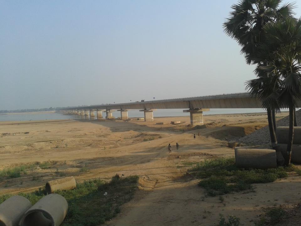
Arwal town is the administrative headquarters of Arwal district in Bihar state of India. It was earlier part of Jehanabad district. The district as formed to control the naxalism in the area. District was formed from the area of two near by districts i.e. Jehanabad and Aurangabad. Arwal has a population of 588,000. Arwal, the district headquarters is approximately 80 km south from the state capital Patna. Arwal town is situated on the right side bank of the river Son, which is a tributary to the River Ganges. [3]
This article needs additional citations for verification. (June 2015) |
Arwal | |
|---|---|
Town | |
 Arwal Location in Bihar, India  Arwal Arwal (India)  Arwal Arwal (Asia) | |
| Coordinates: 25.25°N 84.68°E | |
| Country | |
| State | Bihar |
| District | Arwal |
| Population (2011) | |
| • Total | 51,849 |
| Language | |
| • Official | Hindi[1] |
| • Additional official | Urdu[1] |
| • Regional | Magahi[2] |
| Time zone | UTC+5:30 (IST) |
| PIN | |
| ISO 3166 code | IN-BR |
| Vehicle registration | BR-56 |
| Website | arwal |
Geography
Arwal is located at 25.25°N 84.68°E. It has an average elevation of 67 metres (220 ft).[4] The district headquarters is in Arwal near river (Sone). The state capital, Patna is 65 km to the north.
Language
The official languages are Hindi and Urdu.[1] The regional language spoken here is Magahi.[2]
Economy
In March 2008 the Bihar government approved the construction of a bridge across the Son River at a cost of Rs. 9,742 lakhs[5] from Arwal to Sahar in Bhojpur district. The economy of Arwal depends on agriculture only. Most of the population resides in villages and are farmers. The entire district is well irrigated due to the proper arrangement of canals, except area like kurtha wanshi and karpi. There is no existence of any industry or other business centre.[6]
Population
Arwal District Population.[7]
| Total | Rural | Urban | |
|---|---|---|---|
| Person | 699563 | 699563 | 0 |
| Male | 362945 | 362945 | 0 |
| Female | 336618 | 336618 | 0 |
Transport
NH 110 links Arwal to Bihar Sharif on NH 31. National Highway 139 (old- NH 98) passes through Arwal connecting Aurangabad to Patna. The nearest railway station is Jehanabad (JHD) at 35 km and Anugraha Narayan Road railway station (AUBR)at 60 km.
Notable people
- Tariq Anwar, Cabinet Minister Govt of India
- Akhilesh Prasad Singh, Ex-Minister Govt of India
References
- "52nd Report of the Commissioner for Linguistic Minorities in India" (PDF). nclm.nic.in. Ministry of Minority Affairs. Archived from the original (PDF) on 25 May 2017. Retrieved 27 May 2019.
- "About District - Arwal". Archived from the original on 31 March 2016. Retrieved 27 May 2019.
- "Arwal Bihar Pin code". citypincode.in. Retrieved 19 March 2014.
- "Arwal, India Page". Bihar. Falling Rain Genomics. Retrieved 10 March 2009.
- "
Notice: Undefined variable: Post in /Opt/Lampp/Htdocs/Zhouyong/Icas.co.in/List.PHP on line 29
". Archived from the original on 3 March 2016. Retrieved 12 December 2011. - "Arwal Sahar bridge on Sone to come soon". Jai Bihar. Archived from the original on 15 December 2008. Retrieved 10 March 2009.
- "District Population :: Official Website of Arwal District, Bihar". Archived from the original on 16 November 2016. Retrieved 11 October 2016.
Authority control | |
|---|---|
| General |
|
| National libraries | |
На других языках
[de] Arwal
Arwal (Hindi अरवल) ist eine Stadt im indischen Bundesstaat Bihar.- [en] Arwal
Другой контент может иметь иную лицензию. Перед использованием материалов сайта WikiSort.org внимательно изучите правила лицензирования конкретных элементов наполнения сайта.
WikiSort.org - проект по пересортировке и дополнению контента Википедии