world.wikisort.org - India
Arsikere is a city and taluka in the Hassan district in the state of Karnataka, India. It is the second largest city in Hassan district, demographically. Arsikere city municipal council consists of 31 wards. This region is known for its coconut production and is also called Kalpataru Nadu. Arsikere is the taluk headquarters, a major railway junction in the South Western Railway which links Mangalore and Mysore to North Karnataka and a central place for tourists who visit nearby places that do not have rail access, such as Belur, Halebidu and Shravanabelagola, Harnahalli, and Kodimata.
Arsikere
Arasikere Arasikere | |
|---|---|
city | |
| ಅರಸೀಕೆರೆ | |
 Arsikere | |
| Nickname: Arasiya-kere | |
 Arsikere Location in Karnataka, India | |
| Coordinates: 13.3139°N 76.2369°E | |
| Country | |
| State | Karnataka |
| District | Hassan district |
| Founded by | Queen Arasi of hoysala empire |
| Government | |
| • Type | Government of Karnataka |
| • Body | City municipal council arsikere |
| • Constituency | (Arsikere (194)) |
| • MLA | K M Shivalingegowda |
| Area | |
| • city | 11 km2 (4 sq mi) |
| • Rank | 2nd in Hassan District |
| Elevation | 806 m (2,644 ft) |
| Population | |
| • city | 80,000+ |
| • Rural | 320,000+ |
| Demonym | Arsikerians |
| Languages | |
| • Official | Kannada |
| Time zone | UTC+5:30 (IST) |
| PIN | 573103, 573122 |
| Area code | 08174 |
| Geocode | ASK |
| Vehicle registration | KA-13 |
| Website | http://arasikerecity.mrc.gov.in/ |
History
The name Arasikere originates from one of the princesses of the Hoysala Dynasty, who built a lake (kere in Kannada) near the town. Arasi means queen in Kannada. Therefore, it is 'Arasiya+kere' which means "queen's pond".[1] Arasikere was also called Udbhava Sarvajna Vijaya and Ballalapura at various times.
Under the rulers of Vijayanagara, it was under the administrative control of Jagadevaraya of Channaptna and later placed under Thimmappa Nayaka of Tarikere. It was finally under the rule of Shivappa Nayaka of Ikkeri and was acquired from Ikkeri rulers by the Mysore Wodeyars in 1690.
Under the rule of the Wodeyars of Mysore, the area suffered from the raids of the Marathas, and was subsequently turned over to the Marathas by the Wodeyars as security for the payment of tribute.
Geography
Arsikere is located at 13°18′52″N 76°15′25″E.[2] It has an average elevation of 812 metres (2,664 feet).
Arsikere is situated about 44 kilometres (27 miles) from Hassan and 166 kilometres (103 miles) from Bengaluru on the Bengaluru-Miraj railway line and National Highway 73, passes through the city, connecting it to Mangaluru and to Shivamogga,via NH-69 from Banavara.
Towards northeast of the city, there is a mountainous scrub forest, known as the Nagapuri Forest. Old temples are found in isolation. Bears and Leopards population is the highlight of this forest. The elevation of the forest lies between 900 metres (3,000 ft) to 1,240 metres (4,070 ft) above mean sea level.[3]
Climate
The winter temperature averages between 14 °C (57 °F) and 26 °C (79 °F). Summer temperature average between 19 °C (66 °F) and 35 °C (95 °F).[4]
Education
Notable educational facilities in Arsikere include the following:
School's and Colleges
- St Mary's High school
- Sri Adichunchanagiri English School, Higher primary school, Arsikere
- St marys school (Kannada medium)
- Niveditha English Higher primary school
- Ananth International school
- St Mary's English Higher primary school
- Aashirvad Public school
- Sharadha English school
- Sri Basvarajendra High School
- Sri Gouramma School
- Sri Vasavi School
- Sri Vidyashankara Public School
- Anubhava Mantapa (S.T.J)
- Rotary school
- Basaveshwara higher primary school
- Sri Vidya Shankara Public School
- Podar International School
Colleges
- Jnanashree expert pu college
- KPS pu college, arsikere
- Ananth PU College
- Adhichunchanagiri Science PU college
- Siddeshwara pu college
- Prathiba College
- JSKPU College
- Vivekananda College of Education
- Government Boys Junior College
- Hoysaleshwara pu college
- Ananthasadvidya College of Education
- Al Ameen College
- Hoysaleshwara degree College
- Vivekananda BEd College
- Govt first grade college Arasikere
- St. Mary's composite PU College for commerce
- Royal institute Of Commerce(Royal Degree College)
Transportation
Arsikere railway junction belongs to the Mysore division and is a major railway junction between Bengaluru – Hubli, Bengaluru – Shivamogga, Mysuru – Shivamogga and also connects Mangalore via hassan railway station. Trains typically stop here before heading to Hassan, Bangalore, Hubli, Mysuru and Mangalore.
Nearly 100 trains stop here and is around 166 km from state capital Bengaluru. It has five trains starts from here to Bengaluru, Mysuru, Shivamogga and Hubballi. Around 30,000 people travel from Arsikere to other parts of Karnataka every day.
Festivals
Various festivals are celebrated in Arasikere, including the following:
- Ganapathi Pendal (where a large Ganesha statue is displayed for about ninety days in Pendal), Ganapathi Chathurti, and Ganapathi Visarjana which has been celebrated from past 72(in 2017) years (where an idol of Ganesha is immersed into the lake near Arasikere). During these festivals, Sports, cultural, and spiritual activities are organized.
- Undiganalu "Sri Kariyamma Devi Jatramahotsava" is the biggest festival in Arasikere taluk which is held in the month of April.
- Yadhapura "Sri Jenukallu Siddeshwara Swamy Jatramahotsava" is a big festival held every month during full moon day.
- Malekallu Thirupathi Fair takes place annually for the god Venkataramana and Govindaraja.
Places of interest
Notable places around Arsikere include the following:
Temples and architecture
- The Kalameshwara Temple (also Ishwara), also known as Kattameshvara and Chandramoulishvara by devotees, is a monument in the Hoysala style of architecture. It faces east and dates to 1220 A.D.
- Sahasrakuta Jinalaya has a Hoysala building from 1220 A.D. and was constructed by Vasudhaika bandhava Recharasa, a minister of Veera Ballala II.
- Malekal Tirupathi Hill, also called (Chikka Tirupati) is three kilometers from Arsikere and has two temples: (Venkataramana and Govindaraja), which are frequently visited by pilgrims. Malekal Tirupathi Hill has 1,300 steps and a standing Venkateshwara idol.[1]
- Chikka Tirupati which is also called as Malekallu Tirupati or Amaragiri Malekallu Tirupati. It is located 3 km away from Arsikere, Hassan district. The main God worshipped here is Lord Balaji or Sri Venkataramana Swamy. There is a temple on the top of the hill which contains 1300 steps. There is a belief that sage Agasthya had offered prayers here to Lord Balaji and was blessed with lords Darshan here. It is also said that sage Vashista lived here and went to atonement by worshipping Lord Venkataramana Swamy, and on the day of Suddha Dwadashi Lord appeared and blessed him and hence this day every year a Maharathothsava will be held and is celebrated as one of the biggest fest. On this day we can find many people who climb the hill and offer prayers to Lord. And also there will be huge gathering for Rathothsava. Even at the bottom of the hill there is a temple built and Vigraha installed here, too. This was done by a Palegar. The temple is built in Hoysala architecture. The temple is combination of Dravidian Architecture and Nagara style. There is a beautiful Kalyani near the temple. Tourists come for the attractive local nature. And it is one of the must visit places in and around Arsikere.
- Hirekallu Sri Siddeshwara Betta Near JC PURA Ramanahalli Forest well known pilgrim center and very beautiful place for one day trekking Power full God also .
- Sainatha and Ganapathi temples are of modern design and construction.
- Jenukallu Siddeshwara swamy hill

Jenukallu siddeshwara Betta (hill) - Arasikere is home to naturally built elephant stone, situated at heart of the town in Shri Subrahmanya Ane Betta.
- Sri Siddarameshwara Temple in Sunkadahalli,
- Sri Siddarameshwara Gadduge is located 12 kilometers from Arsikere, near Banavara.
- Sri Devamma Devi Devalaya T Kodihalli near Thalalur is located 10 kilometers from Arsikere town.
- Sri Veerabhadra Swami and Honaldajji Temple of Jajur is located 2 kilometers from Arsikere center.
- Shree shyla Mallikarjuna temple, Challapura is located 8 kilometers from trekking*

Others
- The Nagapuri fortress, built on the Hirekal hill, is eleven kilometres north of Arasikere and is said to have been constructed by Hyder Ali.
- A state branch of the Kastur Ba Gandhi National Memorial Trust is located at Kastur Ba Gram.
- Garudanagiri hill, which is 25 kilometers from arsikere has a fort on the top of the hill. It is a good place for trekking.
Nearby towns and places of interest
- Undiganalu which is the village located in between Arasikere and Javagal there are historical temples called Kariyamma Devi Temple, Chamundeshwari Temple, Gavisiddeshwara temple (located in the hill top), Bhalu Basaveshwara Temple (located midway). There are many festivals in that the Kariyamma Devi Jathramahothsava is the one of the popular festivals in Arasikere Taluk. Unidiganalu is located 28 km from Arasikere and 11 km from Javagal.
- Javagal, the hobli, is about 33 km from Arasikere and about 35 km from Hassan. It has a temple dedicated to Lakshminarasimha, which is a good specimen of Hoysala architecture with an outer entrance. This temple is attributed to the middle of the 13th century A.D.[5]
- Haranahally is a big village about eight kilometres south of Arasikere; there are remains of an old fort that is said to have been erected in 1070 A.D. by a chief named Someshvara Raya. There is a large Nagarti tank, which was named after his daughter.
- Bannavara is a nearby town where on can see an old forts and a temple.
Notable people
Notable people from Arsikere include:
M L A K M Shivalinge Gowda
- Balakrishna, Kannada actor
- David Johnson, cricketer
- Javagal Srinath, Indian cricketer and pace bowler
- Ashok Haranahalli, Former Advocate General to Govt. of Karnataka
- Haranahalli Ramaswamy, Former Irrigation Minister and founding member of the Malnad Education Trust
- Channa Keshava Sharma, Freedom fighter and Tamra Pathra Awardee
- Narayana Gowda, Chief of Karnataka Rakshana Vedike
- Chandrika, actress in Kannada Film Industry
- Aparna, actress, Kannada anchor
- Dr. H. R. Swamy, A rationalist, environmentalist, Theatre person, Thinker
- D. S. Ramaswamy, Poet
- Rajanand, Kannada actor
- D Shankar Singh, Kannada producer/director
- Dhananjay (actor), Kannada actor
- Doddanna, Kannada actor
Image gallery
 Positioning of Hassan district in Karnataka
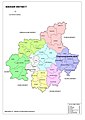 Hobli Map of Hassan district
 Malekallu Temple
 Railway Station
 Hill Temple Road
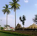 Shivalaya Temple
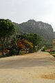 Mini Thirupathi Hills
 Arsikere Hill Temple
 Map of Arasikere Taluk as per 2001 Census
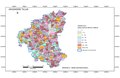 Map of Arasikere Taluk as per 2011 Census
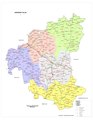 Arasikere Taluk – Hobli and Village Map
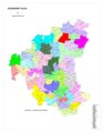 Arasikere Taluk – Grama Panchayat and Village Map
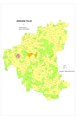 Arasikere Taluk Map about Fluoride content in DWS


See also
- Arakere Village
- Ajjanahalli, Arsikere
- Banavara
- Hoysala architecture
- Kanakatte
- Singarasa
- Channarayapatna
- Munjenahalli
- Gandasi Handpost
References
- Home | ಅರಸೀಕೆರೆ ಪುರಸಭೆ Archived 14 March 2013 at the Wayback Machine. Arasikeretown.gov.in (10 May 2013).
- "Arsikere, India Page". Falling Rain Genomics, Inc. Retrieved 11 September 2017.
- "Nagapuri forest". Retrieved 21 June 2019.
- "Home | ಅರಸೀಕೆರೆ ಪುರಸಭೆ". Archived from the original on 14 March 2013. Retrieved 24 December 2012.
- Karnataka State Gazetteer 1983.
На других языках
[de] Arsikere
Arsikere auch Arasikere (Kannada ಅರಸೀಕೆರೆ) ist eine ca. 55.000 Einwohner zählende Stadt im Distrikt Hassan im südwestindischen Bundesstaat Karnataka.- [en] Arsikere
Другой контент может иметь иную лицензию. Перед использованием материалов сайта WikiSort.org внимательно изучите правила лицензирования конкретных элементов наполнения сайта.
WikiSort.org - проект по пересортировке и дополнению контента Википедии