world.wikisort.org - Germania
Nordwestuckermark è un comune del Brandeburgo, in Germania.
Appartiene al circondario (Landkreis) dell'Uckermark (targa UM).
| Nordwestuckermark comune | ||
|---|---|---|
| ||
 | ||
| Localizzazione | ||
| Stato | ||
| Land | ||
| Distretto | Non presente | |
| Circondario | Uckermark | |
| Territorio | ||
| Coordinate | 53°22′59″N 13°40′00″E | |
| Altitudine | 93 m s.l.m. | |
| Superficie | 254,31 km² | |
| Abitanti | 4 194 (31-12-2019) | |
| Densità | 16,49 ab./km² | |
| Altre informazioni | ||
| Cod. postale | 17291 | |
| Prefisso | 03984, 039852, 039853, 039855 e 039859 | |
| Fuso orario | UTC+1 | |
| Codice Destatis | 12 0 73 429 | |
| Targa | UM | |
| Cartografia | ||
 Nordwestuckermark | ||
 | ||
| Sito istituzionale | ||

Non esiste alcun centro abitato denominato «Nordwestuckermark»; si tratta pertanto di un comune sparso.
Società
Evoluzione demografica
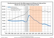 Sviluppo della popolazione dal 1875 entro gli attuali confini (Linea Blu: Popolazione; Linea puntata: Confronto dello sviluppo della popolazione dello stato del Brandenburgo; Sfondo grigio: Ai tempi del governo nazista; Sfondo rosso: Al tempo del governo comunista)
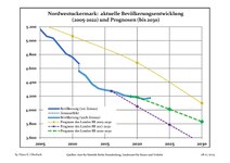 Sviluppo recente della popolazione (Linea blu) e previsioni


|
|
|
Fonti dei dati sono nel dettaglio nelle Wikimedia Commons.[2].
Geografia antropica
Il comune di Nordwestuckermark è diviso nelle frazioni (Ortsteil) di Ferdinandshorst, Fürstenwerder, Gollmitz, Holzendorf, Kraatz, Naugarten, Röpersdorf/Sternhagen, Schapow, Schönermark e Weggun, e comprende le località abitate (Bewohnter Gemeindeteil) di Arendsee, Augustfelde, Beenz, Bülowssiege, Christianenhof, Damerow, Falkenhagen, Ferdinandshof, Fiebigershof, Fischershof, Groß Sperrenwalde, Horst, Klein Sperrenwalde, Kröchlendorff, Lindenhagen, Parmen, Raakow, Rittgarten, Schmachtenhagen, Schulzenhof, Waldsiedlung, Warbende, Wilhelmshayn, Wilhelmshof, Wittstock, Zernikow e Zollchow, e i nuclei abitati (Wohnplatz) di Ausbau, Birkenhain, Bollmannshof, Dochower Mühle, Dollshof, Friedenshof, Hof Sternhagen, Hohenzollchow, Kiecker, Kruseshof, Louisenthal, Röpersdorf, Sternhagen e Ulrichshof.[3]
Note
- Fonti dei dati sono nel dettaglio nelle Wikimedia Commons. Population Projection Brandenburg at Wikimedia Commons
- Population Projection Brandenburg at Wikimedia Commons, su commons.wikimedia.org.
- (DE) Gemeinde Nordwestuckermark, su service.brandenburg.de.
Altri progetti
 Wikimedia Commons contiene immagini o altri file su Nordwestuckermark
Collegamenti esterni
- (DE) Sito ufficiale, su gemeinde-nordwestuckermark.de.
| Controllo di autorità | VIAF (EN) 138152282 · GND (DE) 10033372-2 · WorldCat Identities (EN) viaf-138152282 |
|---|
На других языках
[de] Nordwestuckermark
Nordwestuckermark ist eine amtsfreie Gemeinde im Landkreis Uckermark in Brandenburg (Deutschland).[en] Nordwestuckermark
Nordwestuckermark is a municipality in the Uckermark district, in Brandenburg, Germany.[fr] Nordwestuckermark
Nordwestuckermark (littéralement nord-ouest de la Marche de l'Ucker) est une commune d'Allemagne qui se situe dans l'arrondissement d'Uckermark (Brandebourg). La majorité de son territoire se trouve dans le parc naturel des lacs de la Marche de l'Ucker.- [it] Nordwestuckermark
[ru] Нордвестуккермарк
Но́рдвестуккермарк (нем. Nordwestuckermark) — коммуна в Германии, в земле Бранденбург.Другой контент может иметь иную лицензию. Перед использованием материалов сайта WikiSort.org внимательно изучите правила лицензирования конкретных элементов наполнения сайта.
WikiSort.org - проект по пересортировке и дополнению контента Википедии