world.wikisort.org - Allemagne
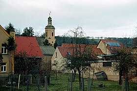
Rauda est une commune allemande de l'arrondissement de Saale-Holzland, Land de Thuringe.
| Rauda | |||

| |||
| Administration | |||
|---|---|---|---|
| Pays | |||
| Land | |||
| Arrondissement (Landkreis) |
Saale-Holzland | ||
| Bourgmestre (Bürgermeister) |
Hans-Jürgen Dietrich | ||
| Code postal | 07613 | ||
| Code communal (Gemeindeschlüssel) |
16 0 74 072 | ||
| Indicatif téléphonique | 036691 | ||
| Immatriculation | SHK, EIS, SRO | ||
| Démographie | |||
| Population | 291 hab. (31 déc. 2014) | ||
| Densité | 94 hab./km2 | ||
| Géographie | |||
| Coordonnées | 50° 57′ 10″ nord, 11° 56′ 33″ est | ||
| Altitude | 197 m |
||
| Superficie | 309 ha = 3,09 km2 | ||
| Localisation | |||
| Géolocalisation sur la carte : Thuringe
Géolocalisation sur la carte : Allemagne
| |||
| Liens | |||
| Site web | www.heideland-elstertal.de | ||
| modifier |
|||
Géographie
Rauda se situe sur la rivière du même nom. Une partie de son territoire à l'ouest se trouve au nord de l'Eisenberger Mühltal.
Rauda se trouve sur la Bundesstraße 7
Histoire
Rauda est mentionné pour la première fois en 1219.
Source de la traduction
- (de) Cet article est partiellement ou en totalité issu de l’article de Wikipédia en allemand intitulé « Rauda » (voir la liste des auteurs).
- Portail de la Thuringe
На других языках
[de] Rauda
Rauda ist eine Gemeinde im Nordosten des Saale-Holzland-Kreises in der Nähe von Eisenberg und Teil der Verwaltungsgemeinschaft Heideland-Elstertal-Schkölen.[en] Rauda
Rauda is a municipality in the district Saale-Holzland, in Thuringia, Germany.- [fr] Rauda
[ru] Рауда
Рауда (нем. Rauda) — коммуна в Германии, в земле Тюрингия.Текст в блоке "Читать" взят с сайта "Википедия" и доступен по лицензии Creative Commons Attribution-ShareAlike; в отдельных случаях могут действовать дополнительные условия.
Другой контент может иметь иную лицензию. Перед использованием материалов сайта WikiSort.org внимательно изучите правила лицензирования конкретных элементов наполнения сайта.
Другой контент может иметь иную лицензию. Перед использованием материалов сайта WikiSort.org внимательно изучите правила лицензирования конкретных элементов наполнения сайта.
2019-2025
WikiSort.org - проект по пересортировке и дополнению контента Википедии
WikiSort.org - проект по пересортировке и дополнению контента Википедии


