world.wikisort.org - Germany
Wallendorf is an Ortsteil (subdivision) of the Lichte municipality. It is located in the district of Saalfeld-Rudolstadt in Thuringia, Germany, close to the Thuringian Rennsteig.
Wallendorf | |
|---|---|
Ortsteil of Lichte | |
 | |
Location of Wallendorf  | |
 Wallendorf  Wallendorf | |
| Coordinates: 50°31′34″N 11°11′34″E | |
| Country | Germany |
| State | Thuringia |
| District | Saalfeld-Rudolstadt |
| Municipal assoc. | Lichtetal am Rennsteig |
| Municipality | Lichte |
| Elevation | 580 m (1,900 ft) |
| Time zone | UTC+01:00 (CET) |
| • Summer (DST) | UTC+02:00 (CEST) |
| Postal codes | 98739 |
| Dialling codes | 036701 |
| Vehicle registration | SLF |
Geography
Th Ortsteil Wallendorf, consisting of the villages Wallendorf and Lamprecht, is located in a forested area in the southern part of the Thuringian Forest.
History
The documentary first mention of Wallendorf was dated December 29, 1414. Lamprecht as part of Wallendorf was first mentioned in a document December 21, 1386.[1]
The baroque Elisabeth's church, built until 1734, was sponsored by Peter Hohmann and his descendants. The Hohmann family was also owner of the Manor Wallendorf. The so-called Gutshof (manor house) and Fronwiese (lord's meadow) are indications of that historical period.[2]
| Bock-und-Teich | Geiersthal | Lichte with - Washdorf, Ascherbach - Hügel, Oberlichte - Unterlichte |
Wallendorf with - Lamprecht |
 City hall in Wallendorf
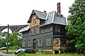 historical "Post Hotel" with viaduct (Saalfelder Str. 32)
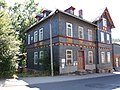 Post office in Wallendorf
 Wallendorfer Porzellanmanufaktur (October 2006)
![Railway viaduct over the Piesau,[3] distinctive sign of Wallendorf](//upload.wikimedia.org/wikipedia/commons/thumb/6/6c/Piesau-Viadukt.jpg/120px-Piesau-Viadukt.jpg)
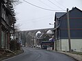 Piesau viaduct ...


![Railway viaduct over the Piesau,[3] distinctive sign of Wallendorf](http://upload.wikimedia.org/wikipedia/commons/6/6c/Piesau-Viadukt.jpg)

See also
- Lichtetal am Rennsteig
- Lichte
- Cultural monuments in Lichte
- Wallendorfer Porzellan
- Lichte (river)
External links
- Homepage of the Municipal Association (Verwaltungsgemeinschaft) (in German)
References
- Wolfgang Kahl (Autor): Ersterwähnung Thüringer Städte und Dörfer. Ein Handbuch. Verlag Rockstuhl, Bad Langensalza, 2010, ISBN 978-3-86777-202-0, S. 302 und 156
- Albert Brödel: From charcoal hovel to industrial area ... as to official sources 1937–1939 (captur: The foundation of the Manor Wallendorf), published by W. Brödel, Kulmbach 1997
- Hans-Joachim Kirsche: Eisenbahndirektion Erfurt 1882–1993. VBN Verlag B. Neddermeyer, Berlin 2006, ISBN 978-3-933254-76-4, S. 64
Towns and municipalities in Saalfeld-Rudolstadt | ||
|---|---|---|
 | ||
| Authority control: National libraries |
|---|
This Saalfeld-Rudolstadt location article is a stub. You can help Wikipedia by expanding it. |
Другой контент может иметь иную лицензию. Перед использованием материалов сайта WikiSort.org внимательно изучите правила лицензирования конкретных элементов наполнения сайта.
WikiSort.org - проект по пересортировке и дополнению контента Википедии