world.wikisort.org - Germany
Schwarzheide (Lower Sorbian: Carny Gózd) is a town in the Oberspreewald-Lausitz district, in Lower Lusatia, Brandenburg, Germany. It is situated on the river Schwarze Elster, 11 km southwest of Senftenberg, 110 km south of Berlin and 40 km north of Dresden. The little river Pössnitz runs through the eastern part of Schwarzheide.
Schwarzheide | |
|---|---|
Town | |
 | |
 Coat of arms | |
Location of Schwarzheide within Oberspreewald-Lausitz district  | |
 Schwarzheide  Schwarzheide | |
| Coordinates: 51°28′59″N 13°52′00″E | |
| Country | Germany |
| State | Brandenburg |
| District | Oberspreewald-Lausitz |
| Government | |
| • Mayor (2016–24) | Christoph Schmidt[1] (Ind.) |
| Area | |
| • Total | 33.23 km2 (12.83 sq mi) |
| Elevation | 99 m (325 ft) |
| Population (2020-12-31)[2] | |
| • Total | 5,568 |
| • Density | 170/km2 (430/sq mi) |
| Time zone | UTC+01:00 (CET) |
| • Summer (DST) | UTC+02:00 (CEST) |
| Postal codes | 01987 |
| Dialling codes | 035752 |
| Vehicle registration | OSL (until 1994 SFB) |
| Website | www.schwarzheide.de |
Neighbouring communities
Immediate neighbors of the town are the towns Ruhland (south), Lauchhammer (west), Schipkau (north) and Senftenberg with the district Brieske (east).
Districts
Schwarzheide has the following districts [3]
- Schwarzheide-West (former Zschornegosda)
- Wandelhof
- Schwarzheide-Mitte
- Schwarzheide-Ost, consisting of Victoria and Naundorf
History
The town's landmark is the watertower. Today´s industrial town, Schwarzheide, was created on October 1, 1936, from the independent communities, Zschornegosda (today Schwarzheide-West) and Naundorf (now part of Schwarzheide-Ost). The name was translated from the Sorbian name, "Zschornegosda", (corny = black, gozd = heath, wood). The date of foundation of this community is unknown. Zschornegosda and Naundorf were founded in the 12th or the 13th century after the Christianization of the Sorbs.
The first written evidence of Naundorf (as Nuwendorff) came from a pledge deed from 1421. Zschornegosda was first written in 1449 (as Cschörnegast) in feudal deed of Duke Frederick II, Elector of Saxony. Naundorf is a typical street village. Zschornegosda is a rotunde called okolnica. The chapel was on the highest point of a sandy knoll.
The development of both villages was retarded by wars, fires, and epidemics. Until the 18th century, the villages had no more than 100 inhabitants.
In 1780, the discovery of lignite coal west of Zschornegosda in Bockwitz lead to mining and the foundation of briquette factories (Ferdinand, Victoria, Victoria II). The river, Schwarze Elster, was drained and converted to a canal, so it was no longer possible to live from fishing. Highway A13 was built in 1936.
- World War II
- In 1937, Brabag (German: Braunkohlen Benzin AG) completed the Brabag II facility in Ruhland-Schwarlheide (the 4th Nazi Germany Fischer-Tropsch plant) to produce gasoline and diesel fuel from lignite coal.[4] The plant was a target of the Oil Campaign of World War II, used Sachsenhausen concentration camp forced labor, and became a post-war Soviet Joint Stock Company. The factory became VEB Synthesewerk Schwarzheide on January 1, 1954.
When the village's population reached eight-thousand inhabitants, the village became a town on January 11, 1967.
After 1990, Synthesewerk Schwarzheide became a part of BASF AG, which manufactures polyurethane.
Political affinity
The river, Schwarze Elster, forms the border between lower and upper Lusatia. From 1635, both Zschornegosda and Naundorf were part of the Electorate of Saxony. In 1815 both villages came to Prussia because of the Congress of Vienna. From 1815 to 1947, they were part of the Prussian Province of Brandenburg. Between 1818 and 1952, Zschornegosda and Naundorf were part of Kreis Calau. From 1952 to 1990, Schwarzheide was a part of Kreis Senftenberg in the Bezirk Cottbus of East Germany.
In 1990, town was annexed to Brandenburg, and, on December 6, 1993, to Oberspreewald-Lausitz.
Parliament
The town parliament of Schwarzheide comprises the mayor and 18 members.
- Christian Democratic Union 5 seats (27.3%)
- Freie Wählergruppe Schwarzheide 4 seats (22.3%)
- Social Democratic Party 3 seats (18.2%)
- The Left 3 seats (17.0%)
- Free Democratic Party 3 seats (15.2%)
The turnout stood at 56,9 percent.
Partnerships
- Krosno Odrzańskie (Poland)
- Karcag (Hungary)
- Piano di Sorrento (Italy)
Demography
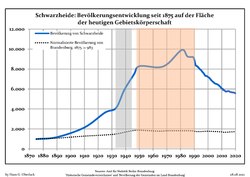 Development of Population since 1875 within the Current Boundaries (Blue Line: Population; Dotted Line: Comparison to Population Development of Brandenburg state; Grey Background: Time of Nazi rule; Red Background: Time of Communist rule)
 Recent Population Development and Projections (Population Development before Census 2011 (blue line); Recent Population Development according to the Census in Germany in 2011 (blue bordered line); Official projections for 2005-2030 (yellow line); for 2017-2030 (scarlet line); for 2020-2030 (green line)


|
|
|
Culture and art

Symbol is the 36 m high water tower built in 1943/44 by French prisoners of war. Lutherkirche from 1754 is also located in the center. The oldest nightclub in eastern Germany is Freizeitpark Wandelhof and there is also a cinema with four sals and 650 places.
Museums
- Kulturhaus of BASF (Schipkauer Straße)
- Museum of Schwarzheide (Dorfaue)
Historical monuments
- Memorial for the victims of the concentration camp
- Monument from 1965 on cemetery Schwarzheide-West for more than 23 unfree workers Brabagvictims
Buildings
- Evangelical church (1953 first new church in the GDR, Otto-Nuschke-Straße)
- Lutheran church (Schwarzheide)
- Evangelical chapel (Parkstraße)
- Catholic Holy Cross church (Otto-Nuschke-Straße)
Natur and recreation areas
Pine forests, lakes, meadows, and pastures surround Schwarzheide. The Lusatian Lake District and Spreewald are also near Schwarzheide.
Sports
Eurospeedway Lausitz is near.
Infrastructure
Transport
federal highway 13 Bundesautobahn 13 from Berlin to Dresden, in south B 169. There is a rail way point in Schwarzheide-Ost.
Street
A 13 (E 55): Berlin–Dresden (Anschlussstelle (16) Schwarzheide and Anschlussstelle (17) Ruhland)
Railway
RE 18: Falkenberg (Elster)–Bad Liebenwerda–Lauchhammer–Ruhland–Schwarzheide-Ost–Senftenberg–Drebkau–Cottbus
Companies
The largest employer is BASF Schwarzheide GmbH, and the company is building a battery supply plant.[6] Other companies include Fränkische Rohrwerke and PeinigerRöRo.
Media
- Local broadcasting Schwarzheide & Ruhland
Education
In Schwarzheide exist a secondary school (Schwarzheide-Wandelhof), a high school (Emil-Fischer), a division of Oberstufenzentrums Lausitz (OSZ) to train laboratory technicians and chemistss, and a music school.
Important persons
Honored
- 2002: Hans-Herman Dehmel (chief executive officer of BASF Schwarzheide from 1990 to 1995)
- 2004: Sokratis Giapapas (chief of Fränkisch Rohrwerke in Schwarzheide)
External links
Notes
- Landkreis Oberspreewald-Lausitz Wahl der Bürgermeisterin / des Bürgermeisters, accessed 2 July 2021.
- "Bevölkerung im Land Brandenburg nach amtsfreien Gemeinden, Ämtern und Gemeinden 31. Dezember 2020". Amt für Statistik Berlin-Brandenburg (in German). June 2021.
- Webseite der Stadt → Stadtentwicklungskonzept, S. 12
- Strange, Anthony N (2003). "Germany's Synthetic Fuel Industry 1927-45" (PDF). Fischer-Tropsch.org. Archived from the original (PDF) on 2015-09-24. Retrieved 2009-10-20.
- Detailed data sources are to be found in the Wikimedia Commons.Population Projection Brandenburg at Wikimedia Commons
- Sauerbier, Michael (10 December 2019). "Nach Tesla: BASF baut in Brandenburg Batteriefabrik für 500 Mio. Euro". bild.de (in German).
Towns and municipalities in Oberspreewald-Lausitz | ||
|---|---|---|
 | ||
На других языках
[de] Schwarzheide
Schwarzheide (bis zum 31. Dezember 1998 Schwarzheide/N.L.[2]; sorbisch Carny Gózd) ist eine amtsfreie Stadt im Landkreis Oberspreewald-Lausitz im Süden des Landes Brandenburg.- [en] Schwarzheide
[ru] Шварцхайде
Шварцхайде (нем. Schwarzheide,луж. Carny Gózd, до 1936 нем. Zschornegosda) — город в Германии, в земле Бранденбург. Входит в состав района Верхний Шпревальд-Лужица.Другой контент может иметь иную лицензию. Перед использованием материалов сайта WikiSort.org внимательно изучите правила лицензирования конкретных элементов наполнения сайта.
WikiSort.org - проект по пересортировке и дополнению контента Википедии