world.wikisort.org - Germany
Schlangenbad is a community in the Rheingau-Taunus-Kreis in the Regierungsbezirk of Darmstadt in Hesse, Germany.
Schlangenbad | |
|---|---|
Municipality | |
 | |
 Coat of arms | |
Location of Schlangenbad within Rheingau-Taunus-Kreis district 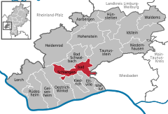 | |
 Schlangenbad  Schlangenbad | |
| Coordinates: 50°5′39″N 8°6′12″E | |
| Country | Germany |
| State | Hesse |
| Admin. region | Darmstadt |
| District | Rheingau-Taunus-Kreis |
| Government | |
| • Mayor (2018–24) | Marco Eyring[1] (CDU) |
| Area | |
| • Total | 36.55 km2 (14.11 sq mi) |
| Elevation | 320 m (1,050 ft) |
| Population (2020-12-31)[2] | |
| • Total | 6,517 |
| • Density | 180/km2 (460/sq mi) |
| Time zone | UTC+01:00 (CET) |
| • Summer (DST) | UTC+02:00 (CEST) |
| Postal codes | 65388 |
| Dialling codes | 06129 |
| Vehicle registration | RÜD |
| Website | www.schlangenbad.de |
Geography
Location
The community, which is a health resort (Kurort), lies 320 m (1,050 ft) above sea level in a sheltered location on a valley slope on the southern slope of the Taunus 12 km (7.5 mi) from Wiesbaden, 7 km (4.3 mi) from Eltville and 7 km (4.3 mi) from Bad Schwalbach.
Neighbouring communities
Schlangenbad borders in the north on the town of Bad Schwalbach, in the east on the town of Taunusstein and the district-free city of Wiesbaden, in the south on the town of Eltville and the community of Kiedrich and in the west on the town of Oestrich-Winkel.
Constituent communities
Schlangenbad's Ortsteile are the state-recognized health resort of Schlangenbad and its outlying centres of Georgenborn, Wambach, Bärstadt, Hausen vor der Höhe, Obergladbach and Niedergladbach.
Climate
In Schlangenbad, the climate is what is known in German as a Schonklima, which means a climate with temperatures that never get too high (no higher than 21 °C (70 °F) in the warmest months) and without great temperature fluctuations, usually occurring together with good shelter from prevailing winds.[3] It does, however, cool off quite sharply in the nighttime. This moderate climate is comparable to a Mediterranean climate.
The temperate climate permits a remnant population of Aesculapian Snakes to survive in the area, despite the general cooling of the climate in what is now Germany. These snakes were once widespread in Middle Europe in warmer times, but are now otherwise only found in Mediterranean lands. Indeed, snakes are Schlangenbad's namesake: the community's name literally means “Snake Bath” in German.
Spa operations


Schlangenbad's thermal springs were discovered in the mid 17th century. Today, nine springs are running altogether. They issue from the ground at temperatures between 21 °C (70 °F) and 32 °C (90 °F) on the south slope of the Bärstädter Kopf. Rheumatic and other inflammatory illnesses are treated at the spa.
Sport and leisure facilities
- Thermal outdoor swimming pool with kelosauna
- Aeskulap-Therme (baths)
- Schlangenbad tennis courts
- Heinz Grein-Sporthalle Georgenborn
- Sporthalle Bärstadt
- Hausen football pitch
Hiking trails
- The Rheinsteig, a new trail from Schloss Biebrich near Wiesbaden to Bonn by way of the Loreley, the “Enemy Brothers” castles (Liebenstein and Sterrenberg) and Lahneck Castle.
- Hiking trail to Rauenthal about 45 minutes away, with an outstanding view over the Rhine Gorge.
- Loop trails at the "Förster-Bitter-Eiche" carpark near the "Hinterlandswald".
Politics
Community council
This section needs to be updated. (July 2021) |
The municipal election held on 26 March 2006 yielded the following results:
| Parties and voter communities | % 2006 |
Seats 2006 |
% 2001 |
Seats 2001 | |
| CDU | Christian Democratic Union of Germany | 48.3 | 15 | 38.0 | 12 |
| SPD | Social Democratic Party of Germany | 26.1 | 8 | 35.6 | 11 |
| GREENS | Bündnis 90/Die Grünen | 12.4 | 4 | 9.6 | 3 |
| FDP | Free Democratic Party | 8.9 | 3 | 12.5 | 4 |
| PRO | PRO-Schlangenbad | 4.2 | 1 | 4.2 | 1 |
| Total | 100.0 | 31 | 100.0 | 31 | |
| Voter turnout in % | 57.7 | 59.0 | |||
Town partnerships
 Craponne, Rhône, France
Education
- Bärstadt primary school
Famous people
Sons and daughters of the town
- Ludwig von Lauter (1855–1929), Prussian artillery general
- Max Knoll (1897–1969), German electrical engineer, codeveloper of the first electron microscope
Former and current Schlangenbad residents
- Ludwig Berger (1892–1969), filmmaker and writer
- Volker Schlöndorff (1939– ), filmmaker and Oscar winner
- Wolf von Lojewski (1937– ), television moderator
- Zascha Kourosh Pezeshkan (1969–Present), KRAFT Construction in Florida
Fiction
- Grant Allen's fictional late 19th century lady detective Miss Lois Cayley visits Schlangenbad in the 1899 novel Miss Cayley's Adventures.
References
- Direkt gewählte (Ober-) Bürgermeister/-innen der hessischen Städte und Gemeinden, accessed 7 July 2021.
- "Bevölkerung in Hessen am 31.12.2020 nach Gemeinden". Hessisches Statistisches Landesamt (in German). June 2021.
- "Definition in German of Schonklima", wetterbote.de, retrieved 12 March 2021
External links
- Schlangenbad at Curlie (in German)
- Hessisan spas - Schlangenbad (in German)
![]() Media related to Schlangenbad at Wikimedia Commons
Media related to Schlangenbad at Wikimedia Commons
Towns and municipalities in Rheingau-Taunus-Kreis district | ||
|---|---|---|
 | ||
Authority control | |
|---|---|
| General | |
| National libraries | |
| Other |
|
На других языках
- [en] Schlangenbad
[ru] Шлангенбад
Шлангенбад (нем. Schlangenbad) — коммуна в Германии, в земле Гессен. Подчиняется административному округу Дармштадт. Входит в состав района Райнгау-Таунус. Население составляет 6233 человека (на 31 декабря 2010 года).[1] Занимает площадь 36,55 км². Официальный код — 06 4 39 014.Другой контент может иметь иную лицензию. Перед использованием материалов сайта WikiSort.org внимательно изучите правила лицензирования конкретных элементов наполнения сайта.
WikiSort.org - проект по пересортировке и дополнению контента Википедии