world.wikisort.org - Germany
Sasbachwalden is a Black Forest municipality in Western Baden-Württemberg, Germany, popular with tourists. It is located on the western slopes of mountain Hornisgrinde in the Northern Black Forest and belongs to the district of Ortenau. More than 70% of the town area are forest.
This article may be expanded with text translated from the corresponding article in German. (February 2009) Click [show] for important translation instructions.
|
Sasbachwalden | |
|---|---|
Municipality | |
 Coat of arms | |
Location of Sasbachwalden within Ortenaukreis district 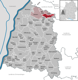 | |
 Sasbachwalden  Sasbachwalden | |
| Coordinates: 48°37′06″N 08°07′38″E | |
| Country | Germany |
| State | Baden-Württemberg |
| Admin. region | Freiburg |
| District | Ortenaukreis |
| Government | |
| • Mayor (2016–24) | Sonja Schuchter[1] |
| Area | |
| • Total | 18.13 km2 (7.00 sq mi) |
| Elevation | 257 m (843 ft) |
| Population (2020-12-31)[2] | |
| • Total | 2,592 |
| • Density | 140/km2 (370/sq mi) |
| Time zone | UTC+01:00 (CET) |
| • Summer (DST) | UTC+02:00 (CEST) |
| Postal codes | 77887 |
| Dialling codes | 07841 |
| Vehicle registration | OG, BH, KEL, LR, WOL |
| Website | www.sasbachwalden.de |
History
Sasbachwalden was first mentioned in 1347 as a group of individual farms and houses. Only in 1817 Sasbachwalden became an independent community. Since 1973 the town belongs to district of Ortenau.
Education
The town has a centrally located kindergarten and elementary school. Institutions for higher education are in the nearby towns Achern and Sasbach.
Economy
Main sources of income are tourism, winegrowing, the production of Black Forest kirsch and most importantly wood processing.
See also
- Alde Gott
References
- Aktuelle Wahlergebnisse, Staatsanzeiger, accessed 13 September 2021.
- "Bevölkerung nach Nationalität und Geschlecht am 31. Dezember 2020" [Population by nationality and sex as of December 31, 2020] (CSV). Statistisches Landesamt Baden-Württemberg (in German). June 2021. Retrieved 17 October 2021.
Towns and municipalities in Ortenau (district) | ||
|---|---|---|
|  | |
Authority control | |
|---|---|
| General | |
| National libraries | |
This Ortenaukreis location article is a stub. You can help Wikipedia by expanding it. |
На других языках
[de] Sasbachwalden
Sasbachwalden ist eine Gemeinde im baden-württembergischen Ortenaukreis. Der staatlich anerkannte Kneipp- und Heilklimatische Kurort liegt am Westrand des nördlichen Schwarzwalds.- [en] Sasbachwalden
[ru] Засбахвальден
Засбахвальден (нем. Sasbachwalden) — коммуна в Германии, в земле Баден-Вюртемберг.Другой контент может иметь иную лицензию. Перед использованием материалов сайта WikiSort.org внимательно изучите правила лицензирования конкретных элементов наполнения сайта.
WikiSort.org - проект по пересортировке и дополнению контента Википедии