world.wikisort.org - Germany
Nachrodt-Wiblingwerde is a municipality in the Märkischer Kreis, North Rhine-Westphalia, Germany.
Nachrodt-Wiblingwerde | |
|---|---|
Town | |
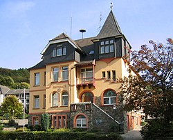
 Old town hall (Amtshaus) | |
 Coat of arms | |
Location of Nachrodt-Wiblingwerde within Märkischer Kreis district  | |
 Nachrodt-Wiblingwerde  Nachrodt-Wiblingwerde | |
| Coordinates: 51°19′0″N 07°39′0″E | |
| Country | Germany |
| State | North Rhine-Westphalia |
| Admin. region | Arnsberg |
| District | Märkischer Kreis |
| Subdivisions | 7 |
| Government | |
| • Mayor (2018–23) | Birgit Tupat[1] (Ind.) |
| Area | |
| • Total | 29.01 km2 (11.20 sq mi) |
| Elevation | 305 m (1,001 ft) |
| Population (2020-12-31)[2] | |
| • Total | 6,466 |
| • Density | 220/km2 (580/sq mi) |
| Time zone | UTC+01:00 (CET) |
| • Summer (DST) | UTC+02:00 (CEST) |
| Postal codes | 58769 |
| Dialling codes | 02352 u. 02334 |
| Vehicle registration | MK |
| Website | www.nachrodt-wiblingwerde.de |
Geography
The municipality is split into two main settlements. Nachrodt is located in the valley of the river Lenne at an altitude of 140 m above sea level, while Wiblingwerde is located at an altitude of 480 m on the hills of the Lennegebirge, one of the hill chains in the Sauerland mountains.
Division of the municipality
|
|
History
The municipality was formed in 1907, when the Amt Altena was dissolved. The two municipalities Kelleramt and Wiblingwerde were merged into the new municipality Nachrodt-Wiblingwerde, which was no longer member in an Amt anymore.
Coat of arms
The coat of arms of the municipality shows in the top part the red and silver rose from the church seal of the Kirchspiel Wiblingwerde. In the bottom is a wavy line representing the river Lenne and thus Nachrodt. Both symbols are separated by the red-and-silver chequered bar of the Mark. The coat of arms was designed by Otto Hupp, and was granted on October 17, 1935.
References
- Bürgermeisterwahl Gemeinde Nachrodt-Wiblingwerde, accessed 21 June 2021.
- "Bevölkerung der Gemeinden Nordrhein-Westfalens am 31. Dezember 2020" (in German). Landesbetrieb Information und Technik NRW. Retrieved 21 June 2021.
External links
![]() Media related to Nachrodt-Wiblingwerde at Wikimedia Commons
Media related to Nachrodt-Wiblingwerde at Wikimedia Commons
- Official site (in German)
- Tourist information (in German)
На других языках
[de] Nachrodt-Wiblingwerde
Nachrodt-Wiblingwerde ist eine Gemeinde in Nordrhein-Westfalen, Deutschland. Sie liegt im Sauerland und gehört zum Märkischen Kreis. Weite Flächen auf den Höhen des Lennegebirges und das enge Tal der Lenne prägen das Gemeindegebiet. Im frühen 19. Jahrhundert begannen sich im derzeitigen Gemeindegebiet metallverarbeitende Betriebe anzusiedeln. Mittelständische Unternehmen im Bereich der Metallverarbeitung sind auch heute noch ansässig. Die Gemeinde entstand 1907 aus dem Zusammenschluss der Gemeinden Kelleramt (seither Nachrodt genannt) und Wiblingwerde. Der Ortsteil Wiblingwerde ist staatlich anerkannter Erholungsort.[2]- [en] Nachrodt-Wiblingwerde
[es] Nachrodt-Wiblingwerde
Nachrodt-Wiblingwerde es un municipio situado en el distrito de Märkischer, en el estado federado de Renania del Norte-Westfalia (Alemania), con una población a finales de 2016 de unos 6594 habitantes.[2][ru] Нахродт-Виблингверде
Нахродт-Виблингверде (нем. Nachrodt-Wiblingwerde) — коммуна в Германии, в земле Северный Рейн-Вестфалия.Другой контент может иметь иную лицензию. Перед использованием материалов сайта WikiSort.org внимательно изучите правила лицензирования конкретных элементов наполнения сайта.
WikiSort.org - проект по пересортировке и дополнению контента Википедии
