world.wikisort.org - Germany
Konzell is a municipality in the district of Straubing-Bogen in Bavaria, Germany.
This article may be expanded with text translated from the corresponding article in German. (March 2009) Click [show] for important translation instructions.
|
Konzell | |
|---|---|
Municipality | |
 Church of Saint Martin | |
 Coat of arms | |
Location of Konzell within Straubing-Bogen district 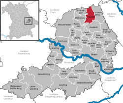 | |
 Konzell  Konzell | |
| Coordinates: 49°4′N 12°43′E | |
| Country | Germany |
| State | Bavaria |
| Admin. region | Niederbayern |
| District | Straubing-Bogen |
| Government | |
| • Mayor (2020–26) | Hans Kienberger[1] (CSU) |
| Area | |
| • Total | 26.76 km2 (10.33 sq mi) |
| Highest elevation | 900 m (3,000 ft) |
| Lowest elevation | 500 m (1,600 ft) |
| Population (2020-12-31)[2] | |
| • Total | 1,812 |
| • Density | 68/km2 (180/sq mi) |
| Time zone | UTC+01:00 (CET) |
| • Summer (DST) | UTC+02:00 (CEST) |
| Postal codes | 94357 |
| Dialling codes | 09963 |
| Vehicle registration | SR |
| Website | www.konzell.de |
Geography
Konzell is situated in the south of the Bavarian Forest. Here is the spring of the Menach, which flows in the valley of Menach direction the Bogen.
Mountains
The Gallner Berg to the south, the western summit of the Gallner, and the Kramerschopf to the east are the highest points, each reaching 710 metres. To the north is the Himmelberg at 680 metres.
Urban districts
To Konzell belong the urban districts Auggenbach, Denkzell, Gossersdorf and Kasparzell.
Impressions
 Rectory
 Primary school
 fountain near school and church
 Brewerie (Klett-Bräu)


References
- Liste der ersten Bürgermeister/Oberbürgermeister in kreisangehörigen Gemeinden, Bayerisches Landesamt für Statistik, 15 July 2021.
- "Tabellenblatt "Daten 2", Statistischer Bericht A1200C 202041 Einwohnerzahlen der Gemeinden, Kreise und Regierungsbezirke". Bayerisches Landesamt für Statistik (in German). June 2021.
Authority control | |
|---|---|
| General |
|
| National libraries | |
This Straubing-Bogen location article is a stub. You can help Wikipedia by expanding it. |
На других языках
- [en] Konzell
[ru] Концелль
Концелль (нем. Konzell) — община в Германии, в Республике Бавария.Текст в блоке "Читать" взят с сайта "Википедия" и доступен по лицензии Creative Commons Attribution-ShareAlike; в отдельных случаях могут действовать дополнительные условия.
Другой контент может иметь иную лицензию. Перед использованием материалов сайта WikiSort.org внимательно изучите правила лицензирования конкретных элементов наполнения сайта.
Другой контент может иметь иную лицензию. Перед использованием материалов сайта WikiSort.org внимательно изучите правила лицензирования конкретных элементов наполнения сайта.
2019-2026
WikiSort.org - проект по пересортировке и дополнению контента Википедии
WikiSort.org - проект по пересортировке и дополнению контента Википедии