world.wikisort.org - Germany
Kolbingen is a municipality in the district of Tuttlingen in Baden-Württemberg in Germany. It is situated about 15 km northeast of Tuttlingen and 7 km from Mühlheim an der Donau.
This article may be expanded with text translated from the corresponding article in German. (February 2009) Click [show] for important translation instructions.
|
Kolbingen | |
|---|---|
Municipality | |
 Coat of arms | |
Location of Kolbingen within Tuttlingen district 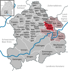 | |
 Kolbingen  Kolbingen | |
| Coordinates: 48°03′08″N 08°53′20″E | |
| Country | Germany |
| State | Baden-Württemberg |
| Admin. region | Freiburg |
| District | Tuttlingen |
| Government | |
| • Mayor (2021–29) | Christian Valentin Abert[1] |
| Area | |
| • Total | 16.49 km2 (6.37 sq mi) |
| Elevation | 854 m (2,802 ft) |
| Population (2020-12-31)[2] | |
| • Total | 1,246 |
| • Density | 76/km2 (200/sq mi) |
| Time zone | UTC+01:00 (CET) |
| • Summer (DST) | UTC+02:00 (CEST) |
| Postal codes | 78600 |
| Dialling codes | 07463 |
| Vehicle registration | TUT |
| Website | www.kolbingen.de |
Farming
To help people to help themselves Württemberg planted alleys of fruit-trees (Dienstbarkeit on private ground near streets). The tree farms from William I of Württemberg, also the Brüdergemeinde delivered for free.[3] The Kolbinger Goldbirne is a local tree.
References
- Aktuelle Wahlergebnisse, Staatsanzeiger, accessed 15 September 2021.
- "Bevölkerung nach Nationalität und Geschlecht am 31. Dezember 2020" [Population by nationality and sex as of December 31, 2020] (CSV). Statistisches Landesamt Baden-Württemberg (in German). June 2021. Retrieved 17 October 2021.
- Apfelgeschichte auf Apfelgut Sulz
External links
- Official Web site for the city of Kolbingen (in German)
Authority control | |
|---|---|
| General | |
| National libraries | |
This Tuttlingen district location article is a stub. You can help Wikipedia by expanding it. |
На других языках
- [en] Kolbingen
[ru] Кольбинген
Кольбинген (нем. Kolbingen) — коммуна в Германии, в земле Баден-Вюртемберг.Текст в блоке "Читать" взят с сайта "Википедия" и доступен по лицензии Creative Commons Attribution-ShareAlike; в отдельных случаях могут действовать дополнительные условия.
Другой контент может иметь иную лицензию. Перед использованием материалов сайта WikiSort.org внимательно изучите правила лицензирования конкретных элементов наполнения сайта.
Другой контент может иметь иную лицензию. Перед использованием материалов сайта WikiSort.org внимательно изучите правила лицензирования конкретных элементов наполнения сайта.
2019-2026
WikiSort.org - проект по пересортировке и дополнению контента Википедии
WikiSort.org - проект по пересортировке и дополнению контента Википедии