world.wikisort.org - Germany
Jonaswalde is a municipality in the Thuringian district of Altenburger Land. It belongs to the Verwaltungsgemeinschaft of Oberes Sprottental.
Jonaswalde | |
|---|---|
Municipality | |
Location of Jonaswalde within Altenburger Land district 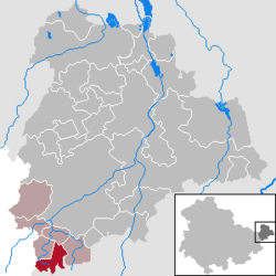 | |
 Jonaswalde  Jonaswalde | |
| Coordinates: 50°50′21″N 12°17′16″E | |
| Country | Germany |
| State | Thuringia |
| District | Altenburger Land |
| Municipal assoc. | Oberes Sprottental |
| Subdivisions | 2 |
| Government | |
| • Mayor (2018–24) | André Vohs[1] |
| Area | |
| • Total | 6.65 km2 (2.57 sq mi) |
| Elevation | 190 m (620 ft) |
| Population (2020-12-31)[2] | |
| • Total | 318 |
| • Density | 48/km2 (120/sq mi) |
| Time zone | UTC+01:00 (CET) |
| • Summer (DST) | UTC+02:00 (CEST) |
| Postal codes | 04626 |
| Dialling codes | 034496 |
| Vehicle registration | ABG |
| Website | www.jonaswalde.de |
Geography
Neighboring municipalities
Nearby municipalities are Heukewalde, Thonhausen, and Vollmershain in the district of Altenburger Land; Rückersdorf in the district of Greiz; as well as the city of Crimmitschau in the Saxon district of Zwickauer Land.
Municipal arrangement
The community is divided into two subdivisions: Jonaswalde and Nischwitz.
History
From 1826 to 1920, Jonaswalde was part of Saxe-Altenburg.
References
- Gewählte Bürgermeister - aktuelle Landesübersicht, Freistaat Thüringen, accessed 14 July 2021.
- "Bevölkerung der Gemeinden, erfüllenden Gemeinden und Verwaltungsgemeinschaften in Thüringen Gebietsstand: 31.12.2020". Thüringer Landesamt für Statistik (in German). June 2021.
External links
- (in German) a private website from Jonaswalde
- (in German) FOSAVIS, a private website from Dirk Salomon, Jonaswalde
Towns and municipalities in Altenburger Land | ||
|---|---|---|
|  | |
Authority control | |
|---|---|
| General |
|
| National libraries | |
This Altenburger Land location article is a stub. You can help Wikipedia by expanding it. |
На других языках
- [en] Jonaswalde
[es] Jonaswalde
Jonaswalde es un municipio situado en el distrito de Altenburger Land, en el estado federado de Turingia (Alemania), a una altitud de 190 metros. Su población a finales de 2016 era de unos 300 habitantes y su densidad poblacional, 45 hab/km².[2][3][ru] Йонасвальде
Йонасвальде (нем. Jonaswalde) — коммуна в Германии, в земле Тюрингия.Текст в блоке "Читать" взят с сайта "Википедия" и доступен по лицензии Creative Commons Attribution-ShareAlike; в отдельных случаях могут действовать дополнительные условия.
Другой контент может иметь иную лицензию. Перед использованием материалов сайта WikiSort.org внимательно изучите правила лицензирования конкретных элементов наполнения сайта.
Другой контент может иметь иную лицензию. Перед использованием материалов сайта WikiSort.org внимательно изучите правила лицензирования конкретных элементов наполнения сайта.
2019-2026
WikiSort.org - проект по пересортировке и дополнению контента Википедии
WikiSort.org - проект по пересортировке и дополнению контента Википедии