world.wikisort.org - Germany
Hohenstein-Ernstthal (German pronunciation: [ˈhoːənˌʃtaɪ̯n ˈɛʁnstˌtaːl] (![]() listen)) is a town in the Zwickau rural district, Saxony, Germany. The towns of Hohenstein and Ernstthal were united in 1898,[3] and the town is either known by its hyphenated form, or simply called Hohenstein.
listen)) is a town in the Zwickau rural district, Saxony, Germany. The towns of Hohenstein and Ernstthal were united in 1898,[3] and the town is either known by its hyphenated form, or simply called Hohenstein.
Hohenstein-Ernstthal | |
|---|---|
Town | |
 Hohenstein-Ernstthal | |
 Coat of arms | |
Location of Hohenstein-Ernstthal within Zwickau district 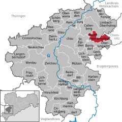 | |
 Hohenstein-Ernstthal  Hohenstein-Ernstthal | |
| Coordinates: 50°48′N 12°43′E | |
| Country | Germany |
| State | Saxony |
| District | Zwickau |
| Government | |
| • Mayor (2019–26) | Lars Kluge[1] (CDU) |
| Area | |
| • Total | 18.33 km2 (7.08 sq mi) |
| Elevation | 355 m (1,165 ft) |
| Population (2021-12-31)[2] | |
| • Total | 14,142 |
| • Density | 770/km2 (2,000/sq mi) |
| Time zone | UTC+01:00 (CET) |
| • Summer (DST) | UTC+02:00 (CEST) |
| Postal codes | 09337 |
| Dialling codes | 03723 |
| Vehicle registration | Z, GC, HOT, WDA |
| Website | hohenstein-ernstthal.de |
The town grew in the 15th century after silver mines were established nearby. Ernstthal was named in honor of August Ernst von Schoenburg.
Physicist Gotthilf Heinrich von Schubert and inventor Christoph Gottlieb Schröter were born in Hohenstein.[3] The writer Karl May was born in Ernstthal. The house of his birth is a museum.
Furthermore, Hohenstein-Ernstthal is especially famous for the Sachsenring racing circuit.
History
In the 15th century, the town of Hohenstein was established after silver was found and mined there. The name is said to be derived from the phrase ″uff dem hohen Stein″ (on the high rock), that the first settlers used when they saw the Pfaffenberg mountain. In 1680 some people from Hohenstein moved to the forest near the town to escape the dangers of the plague. That settlement was later named Ernstthal (Ernst valley) after August Ernst von Schönburg. Both town united in 1898, thus becoming Hohenstein-Ernstthal. During 19th and 20th century silver mining became less efficient, so the textile industry became more important. In 1999, Wüstenbrand became a part of Hohenstein-Ernstthal.[4]
Geography
Hohenstein-Ernsthal is located about 15 kilometres (9.3 mi) west of Chemnitz. The Ore Mountains rise south of the city. The highest point of Hohenstein-Ernstthal is the Pfaffenberg north of the town with an elevation of 479 metres (1,572 ft).
Lord Mayor
- 1994-2012 Erich Homilius
- since 2012 Lars Kluge (CDU), he was elected in September 2012 with 91.9% of the votes, and re-elected in 2019.
Transport
Hohenstein-Ernstthal is adjacent to the Bundesautobahn 4. There are 2 railway stations, the Hohenstein-Ernstthal station and Wüstenbrand station, both on the Dresden–Werdau railway.
Notable people


- Gotthilf Heinrich von Schubert (1780–1860), natural scientist
- Karl May (1842–1912), author
- Hans-Uwe Pilz (born 1958), football player and trainer
- Heinz Tetzner (1920-2007), painter and printmaker
- Christoph Gottlieb Schröter (1699-1782) composer and organist
References
- Wahlergebnisse 2019, Freistaat Sachsen, accessed 10 July 2021.
- "Bevölkerung des Freistaates Sachsen nach Gemeinden am 31. Dezember 2021" (XLS) (in German). Statistisches Landesamt des Freistaates Sachsen. 2022.
- Chisholm, Hugh, ed. (1911). . Encyclopædia Britannica. Vol. 13 (11th ed.). Cambridge University Press. p. 575.
- Gebietsänderungen vom 01.01. bis 31.12.1999, Statistisches Bundesamt
External links
- Official website
 (in German)
Authority control | |
|---|---|
| General | |
| National libraries | |
| Other |
|
На других языках
[de] Hohenstein-Ernstthal
Die Große Kreisstadt Hohenstein-Ernstthal liegt im Osten des Landkreises Zwickau. Bekannt ist die Stadt besonders als Geburtsort des Schriftstellers Karl May und durch den Sachsenring, auf dem unter anderem das Deutschlandrennen der Motorrad-Weltmeisterschaft ausgetragen wird.- [en] Hohenstein-Ernstthal
[es] Hohenstein-Ernstthal
Hohenstein-Ernstthal es una localidad alemana ubicada en el Distrito de Zwickau, región de Chemnitz en el Estado Libre de Sajonia. Los pueblos de Hohenstein y Ernstthal fueron unificados en 1898 y, desde entonces ha sido llamado en su forma compuesta o simplemente Hohenstein.[fr] Hohenstein-Ernstthal
Hohenstein-Ernstthal est une ville d'Allemagne, située dans l'arrondissement de Zwickau dans l'État libre de Saxe.[it] Hohenstein-Ernstthal
Hohenstein-Ernstthal è una città di 16.101 abitanti della Sassonia, in Germania.[ru] Хоэнштайн-Эрнстталь
Хоэнштайн-Эрнстталь (в русской исторической литературе обычно используется название Гогенштейн; нем. Hohenstein-Ernstthal) — город в Германии, в земле Саксония. Подчинён административному округу Кемниц. Входит в состав района Цвиккау[1]. Население составляет 15777 человек (на 31 декабря 2010 года). Занимает площадь 18,33 км². Официальный код — 14 1 73 100.Другой контент может иметь иную лицензию. Перед использованием материалов сайта WikiSort.org внимательно изучите правила лицензирования конкретных элементов наполнения сайта.
WikiSort.org - проект по пересортировке и дополнению контента Википедии