world.wikisort.org - Germany
Grafenwöhr (German pronunciation: [ɡʁaːfn̩ˈvøːɐ̯] (![]() listen), Northern Bavarian: Groafawehr) is a town in the district of Neustadt an der Waldnaab, in the region of the Upper Palatinate (German: Oberpfalz) in eastern Bavaria, Germany. It is widely known for the United States Army military installation and training area, called Grafenwoehr Training Area (Tower Barracks), located directly south and west of the town.
listen), Northern Bavarian: Groafawehr) is a town in the district of Neustadt an der Waldnaab, in the region of the Upper Palatinate (German: Oberpfalz) in eastern Bavaria, Germany. It is widely known for the United States Army military installation and training area, called Grafenwoehr Training Area (Tower Barracks), located directly south and west of the town.
This article needs additional citations for verification. (March 2011) |
Grafenwöhr | |
|---|---|
Town | |
 Town hall | |
 Coat of arms | |
Location of Grafenwöhr within Neustadt a.d.Waldnaab district  | |
 Grafenwöhr  Grafenwöhr | |
| Coordinates: 49°43′N 11°54′E | |
| Country | Germany |
| State | Bavaria |
| Admin. region | Upper Palatinate |
| District | Neustadt a.d.Waldnaab |
| Subdivisions | 12 Ortsteile bzw. Stadtbezirke |
| Government | |
| • Mayor (2020–26) | Edgar Knobloch[1] (CSU) |
| Area | |
| • Total | 216.24 km2 (83.49 sq mi) |
| Elevation | 410 m (1,350 ft) |
| Population (2020-12-31)[2] | |
| • Total | 6,419 |
| • Density | 30/km2 (77/sq mi) |
| Time zone | UTC+01:00 (CET) |
| • Summer (DST) | UTC+02:00 (CEST) |
| Postal codes | 92655 |
| Dialling codes | 09641 |
| Vehicle registration | NEW |
| Website | www.grafenwoehr.de |
History
Early history
The town of Grafenwöhr (Island of the Count), was founded in the 9th century on an island (wöhr), located between the river Creussen and the Thum stream. In its early history, the inhabitants and the town of Grafenwöhr proper belonged to nobles from Schweinfurt, Bamberg, and Leuchtenberg.
20th century
In 1907, Prince Luitpold, regent of the Kingdom of Bavaria, selected the area near the town of Grafenwöhr as the place best suited for training of the Bavarian Army (1806–1919). Construction began in 1908, and, by 1915, the training reservation was 96 square kilometres (37 sq mi) in area. The first artillery round was fired in the training area at 08:00 on 30 June 1910. Throughout World War I (1914–1918) the Grafenwöhr training area was used for equipping and training army units for combat. After the War, the High Command, Berlin, used Grafenwöhr to train the 100,000–man German army, allowed by the Treaty of Versailles (1919).
In 1936, the Nazi Government expanded the training area to the present size of 230 square kilometres (90 sq mi). On 5 and 8 April 1945, the training camp and the town of Grafenwöhr proper were bombed during Allied air raids. The last German Army Commander of the Grafenwöhr training area surrendered to the U.S. Army on 20 April 1945. Afterwards, during the Cold War (1945–1991), the Grafenwöhr training area was an important, combined arms training site for the U.S. Army and allied forces.
Post Cold War
The military installation is also home to one of the largest Army construction projects in Europe, called Efficient Basing-Grafenwöhr. The Grafenwöhr Training Area (Tower Barracks) houses the 7th Army Joint Multinational Training Command (JMTC). The 7th Army JMTC owns almost all of the U.S. Army training facilities and assets in Europe. The Grafenwöhr Training Area is one of its largest training areas and includes ranges that can accommodate nearly every weapons system currently used.
Though operated by the U.S. Army, the area is the largest multinational training area in Europe. Grafenwöhr Training Area is (Tower Barracks), also known as the East Camp, is the main post and is located on the north east edge of the training area. The Vilseck military community, also known as Rose Barracks, or the South Camp, is on the southern boundary.
The Grafenwöhr Army Airfield provides air flow to all air traffic requesting services including but not limited C-130's from the 37th Airlift Squadron at Ramstein AB, Germany. The airfield is staffed 24 hours a day by advisory services and at a minimum from 08:00 to 17:00 by air traffic controllers both in a control tower and an approach control. Due to its length and relative proximity to the JMTC training area, it makes for a realistic simulation of short field operations encountered around the world. Bunker dropzone is also located within the Grafenwöhr Training Area. It is used to practice airdrop of troops, equipment, and supplies.
Geography
The civilian town of Grafenwöhr rests nestled between low hills. The area is widely forested and the nearby region is mostly used for agricultural purposes. Farms and dairies cover much of the surrounding landscape. Grafenwöhr is positioned geographically such that it experiences very mild summers and cold winters.
Climate
Climate in this area has mild differences between highs and lows, and there is adequate rainfall year-round. The Köppen Climate Classification subtype for this climate is "Cfb" (Marine West Coast Climate/Oceanic climate).[3]
| Climate data for Grafenwöhr | |||||||||||||
|---|---|---|---|---|---|---|---|---|---|---|---|---|---|
| Month | Jan | Feb | Mar | Apr | May | Jun | Jul | Aug | Sep | Oct | Nov | Dec | Year |
| Average high °C (°F) | 1 (33) |
3 (37) |
7 (45) |
12 (54) |
18 (64) |
21 (69) |
23 (73) |
22 (72) |
18 (65) |
13 (55) |
6 (42) |
2 (35) |
12 (54) |
| Average low °C (°F) | −6 (22) |
−5 (23) |
−2 (28) |
1 (34) |
6 (42) |
8 (47) |
10 (50) |
10 (50) |
7 (44) |
3 (37) |
−1 (31) |
−4 (25) |
2 (36) |
| Average precipitation mm (inches) | 48 (1.9) |
38 (1.5) |
43 (1.7) |
41 (1.6) |
56 (2.2) |
74 (2.9) |
69 (2.7) |
61 (2.4) |
51 (2) |
46 (1.8) |
51 (2) |
56 (2.2) |
630 (24.9) |
| Average precipitation days | 15 | 12 | 13 | 12 | 14 | 15 | 12 | 12 | 12 | 11 | 15 | 15 | 158 |
| Source: Weatherbase [4] | |||||||||||||
Sports
- Soccer: SV Grafenwöhr. The adults and children mostly all are in either the Kreisliga or Bezirksoberliga.[5]
- Fishing: The area around Grafenwöhr is excellent for fishing. There are many lakes on the training area and the surrounding area that are fished. Common fish landed in the area are Carp, Pike, Rainbow Trout, and Brown Trout.
- Hunting: The area around Grafenwöhr is heavily forested and provides for excellent hunting. Wild boar (Wildschwein), roe deer (Reh) and red deer (Rotwild) are the most commonly hunted animals.
- Other: The U.S. Military hosts a wide variety of sports within the boundaries of the camps.
Transport
- Road: Grafenwöhr is located along Bundesstrasse B299. Civilian transportation to, from, in, and around Grafenwöhr is limited to the automobile. There are a limited number of taxi and bus services available.
- Rail: The only railroad in Grafenwöhr is strictly for military use and transport only. However, there are several rail stations nearby where civilian passenger trains run. The closest Bahnhofs (rail stations) are Pressath, Schwarzenbach, Freihung, and Vilseck.
- Air: The only airfield in Grafenwöhr is strictly for military use and transport only. The closest international airport is located in Nuremberg, approximately 90 kilometers away.
VIPs and important visitors
- Prince Luitpold, (1821-1912), gave the approval to build the training area on December 9, 1906. [6]
- Elvis Presley, (1935-1977), was on the military training place from November 3, 1958, for six weeks while he was doing his military service, then visited the base on four occasions, two in 1959, and two in 1960 [7]
Media
American Forces Network (AFN) Bavaria broadcasts from the Grafenwöhr Training Area. Bavarian Times Magazine provides news, shopping, dining and other information about the Grafenwohr area. The Bavarian Times is a military magazine for the Grafenwöhr Training Area
Photo gallery
 Grafenwöhr AFN FM radio mast
 Grafenwöhr town center
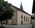 Church Pfarrkirche Mariä Himmelfahrt
 Alte Amberger Straße
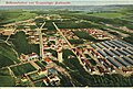 Training camp and area around 1911


References
- Liste der ersten Bürgermeister/Oberbürgermeister in kreisangehörigen Gemeinden, Bayerisches Landesamt für Statistik, 15 July 2021.
- "Tabellenblatt "Daten 2", Statistischer Bericht A1200C 202041 Einwohnerzahlen der Gemeinden, Kreise und Regierungsbezirke". Bayerisches Landesamt für Statistik (in German). June 2021.
- Climate Summary for Grafenwöhr
- "Weatherbase.com". Weatherbase. 2013. Retrieved on June 15, 2013.
- SV-Grafenwöhr Online[permanent dead link]
- "Errichtung".
- Olaf Meiler (2005-01-11). "Elvis Presley als Soldat auf dem Truppenübungsplatz Grafenwöhr i.d. Oberpfalz" (in German). Deutsch-Amerikanisches Volksfest Grafenwöhr. Archived from the original (text/html) on 2013-01-24. Retrieved 2014-05-12.
External links
- Bob Decker's site includes a couple of stylized maps showing Graf
- 7th Army JMTC website
- "Elvis in der Oberpfalz" (german)
Towns and municipalities in Neustadt an der Waldnaab (district) | ||
|---|---|---|
|  | |
Authority control | |
|---|---|
| General | |
| National libraries | |
| Other | |
На других языках
[de] Grafenwöhr
Grafenwöhr ist eine Stadt im Oberpfälzer Landkreis Neustadt an der Waldnaab. Die flächengrößte Gemeinde Nordbayerns ist durch den Truppenübungsplatz Grafenwöhr überregional bekannt.- [en] Grafenwöhr
[es] Grafenwöhr
Grafenwöhr, también escrito Grafenwoehr, es una ciudad de Alemania, localizada en la región del Alto Palatinado, dentro del estado federado de Baviera. Tiene 6.470 habitantes[ru] Графенвёр
Графенвёр (нем. Grafenwöhr) — город и городская община в Германии, в земле Бавария.Другой контент может иметь иную лицензию. Перед использованием материалов сайта WikiSort.org внимательно изучите правила лицензирования конкретных элементов наполнения сайта.
WikiSort.org - проект по пересортировке и дополнению контента Википедии