world.wikisort.org - Germany
Gerbstedt (German pronunciation: [ˈɡɛʁpˌʃtɛt] (![]() listen)) is a small town in Saxony-Anhalt, district Mansfeld-Südharz. It was traditionally dominated by of copper mining, presently agriculture is dominant.
listen)) is a small town in Saxony-Anhalt, district Mansfeld-Südharz. It was traditionally dominated by of copper mining, presently agriculture is dominant.
 Tower of former monastery Gerbstedt
 Town hall Gerbstedt
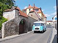 View of Gerbstedt with a rare Robur bus


Gerbstedt | |
|---|---|
Town | |
 Coat of arms | |
Location of Gerbstedt within Mansfeld-Südharz district  | |
 Gerbstedt  Gerbstedt | |
| Coordinates: 51°37′59″N 11°37′0″E | |
| Country | Germany |
| State | Saxony-Anhalt |
| District | Mansfeld-Südharz |
| Subdivisions | 9 |
| Government | |
| • Mayor (2021–28) | Ulf Döring[1] (CDU) |
| Area | |
| • Total | 102.28 km2 (39.49 sq mi) |
| Elevation | 155 m (509 ft) |
| Population (2020-12-31)[2] | |
| • Total | 6,964 |
| • Density | 68/km2 (180/sq mi) |
| Time zone | UTC+01:00 (CET) |
| • Summer (DST) | UTC+02:00 (CEST) |
| Postal codes | 06347 |
| Dialling codes | 03476, 034773, 034783 |
| Vehicle registration | MSH, EIL, HET, ML, SGH |
Geography
The town Gerbstedt is located 9 km (5.59 mi) west of Hettstedt and 13 km (8.08 mi) north of the town Eisleben.
Divisions
The town of Gerbstedt is divided into twelve localities (Ortschaften),[3] corresponding to the twelve former municipalities that formed the current town in 2010.[4] Some of the localities consist of a number of Ortsteile (local parts).
- Augsdorf
- Freist (incl. Elben, Oeste, Reidewitz, Zabitz)
- Friedeburg
- Friedeburgerhütte (incl. Adendorf)
- Gerbstedt
- Heiligenthal (incl. Helmsdorf, Lochwitz)
- Hübitz
- Ihlewitz (incl. Pfeiffhausen, Straußhof, Thaldorf)
- Rottelsdorf (incl. Bösenburg)
- Siersleben (incl. Thondorf)
- Welfesholz
- Zabenstedt
Sons and daughters of the town

- Otto Brosowski (1885–1947), mining worker, KPD member
- Eugen Ray (1957–1986), athlete
- Valentin Haussmann (died c. 1611), composer
Other persons associated with Gerbstedt
- Rikdag, (died 985), Margrave of Meißen
- Friedrich Gottlieb Klopstock, (1724–1803), poet, spent his youth in Friedeburg
- Eckard I, Margrave of Meissen, buried in the Abbey
References
- Bürgermeisterwahlen in den Gemeinden, Endgültige Ergebnisse, Statistisches Landesamt Sachsen-Anhalt, accessed 10 November 2022.
- "Bevölkerung der Gemeinden – Stand: 31. Dezember 2020" (PDF). Statistisches Landesamt Sachsen-Anhalt (in German). June 2021.
- Hauptsatzung der Stadt Gerbstedt, June 2021.
- Gebietsänderungen vom 01. Januar bis 31. Dezember 2010, Statistisches Bundesamt
Wikimedia Commons has media related to Gerbstedt.
Towns and municipalities in the district of Mansfeld-Südharz | ||
|---|---|---|
 | ||
This Mansfeld-Südharz location article is a stub. You can help Wikipedia by expanding it. |
На других языках
[de] Gerbstedt
Gerbstedt ist eine Kleinstadt im Landkreis Mansfeld-Südharz in Sachsen-Anhalt.- [en] Gerbstedt
[ru] Гербштедт
Гербштедт (нем. Gerbstedt) — город в Германии, в земле Саксония-Анхальт.Текст в блоке "Читать" взят с сайта "Википедия" и доступен по лицензии Creative Commons Attribution-ShareAlike; в отдельных случаях могут действовать дополнительные условия.
Другой контент может иметь иную лицензию. Перед использованием материалов сайта WikiSort.org внимательно изучите правила лицензирования конкретных элементов наполнения сайта.
Другой контент может иметь иную лицензию. Перед использованием материалов сайта WikiSort.org внимательно изучите правила лицензирования конкретных элементов наполнения сайта.
2019-2026
WikiSort.org - проект по пересортировке и дополнению контента Википедии
WikiSort.org - проект по пересортировке и дополнению контента Википедии