world.wikisort.org - Germany
Feldberg is a municipality in the district of Breisgau-Hochschwarzwald in Baden-Württemberg in southern Germany. It is located near the Feldberg, the highest summit in Baden-Württemberg. It comprises the settlements of Altglashütten, Neuglashütten, Falkau, Bärental, and Feldberg. At an elevation of 1,277 m, the last is considered the highest village in Germany.
This article may be expanded with text translated from the corresponding article in German. (February 2009) Click [show] for important translation instructions.
|
Feldberg | |
|---|---|
Municipality | |
 Center of Altglashütten in August 2015 | |
 Coat of arms | |
Location of Feldberg within Breisgau-Hochschwarzwald district 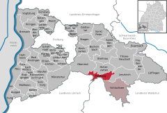 | |
 Feldberg  Feldberg | |
| Coordinates: 47°51′22″N 8°6′42″E | |
| Country | Germany |
| State | Baden-Württemberg |
| Admin. region | Freiburg |
| District | Breisgau-Hochschwarzwald |
| Government | |
| • Mayor (2019–27) | Johannes Albrecht[1] |
| Area | |
| • Total | 24.97 km2 (9.64 sq mi) |
| Elevation | 1,277 m (4,190 ft) |
| Population (2020-12-31)[2] | |
| • Total | 1,849 |
| • Density | 74/km2 (190/sq mi) |
| Time zone | UTC+01:00 (CET) |
| • Summer (DST) | UTC+02:00 (CEST) |
| Postal codes | 79868 |
| Dialling codes | 07676 / 07655 |
| Vehicle registration | FR |
| Website | www.feldberg-schwarzwald.de |
Geography
The Feldberg municipality has the slogan "The highest in the Black Forest" and is located in the Southern Black Forest Nature Park at the Feldberg Pass. It is located between Wiesental (to the south) and Gutachtal (to the north). The largest section of the municipality is the "Falkau" area, where the town hall is located.
Community structure
The current Feldberg municipality includes the three former municipalities of Feldberg, Altglashütten, and Falkau and consists of 30 villages, sections, farms, and cottages and houses.
Climate
Feldberg has a subarctic climate (Dfc) due to its high altitude with short, cool summers and long, cold winters. Precipitation is very high and frequent year round.
| Climate data for Feldberg, Baden-Württemberg, 1490 m asl (1981–2010 normals) | |||||||||||||
|---|---|---|---|---|---|---|---|---|---|---|---|---|---|
| Month | Jan | Feb | Mar | Apr | May | Jun | Jul | Aug | Sep | Oct | Nov | Dec | Year |
| Record high °C (°F) | 12.9 (55.2) |
16.7 (62.1) |
14.5 (58.1) |
19.3 (66.7) |
22.9 (73.2) |
27.0 (80.6) |
27.4 (81.3) |
26.4 (79.5) |
24.6 (76.3) |
21.2 (70.2) |
18.1 (64.6) |
13.9 (57.0) |
27.4 (81.3) |
| Mean maximum °C (°F) | 7.5 (45.5) |
7.9 (46.2) |
9.8 (49.6) |
13.1 (55.6) |
17.7 (63.9) |
20.3 (68.5) |
22.4 (72.3) |
21.8 (71.2) |
18.3 (64.9) |
16.3 (61.3) |
12.3 (54.1) |
8.7 (47.7) |
23.5 (74.3) |
| Average high °C (°F) | −0.1 (31.8) |
−0.5 (31.1) |
1.5 (34.7) |
4.7 (40.5) |
9.4 (48.9) |
12.4 (54.3) |
14.9 (58.8) |
14.6 (58.3) |
11.0 (51.8) |
8.1 (46.6) |
3.0 (37.4) |
−0.7 (30.7) |
6.5 (43.7) |
| Daily mean °C (°F) | −2.5 (27.5) |
−2.9 (26.8) |
−0.9 (30.4) |
2.1 (35.8) |
6.6 (43.9) |
9.6 (49.3) |
12.1 (53.8) |
12.0 (53.6) |
8.6 (47.5) |
5.6 (42.1) |
0.7 (33.3) |
−1.7 (28.9) |
4.1 (39.4) |
| Average low °C (°F) | −4.9 (23.2) |
−5.3 (22.5) |
−3.3 (26.1) |
−0.6 (30.9) |
3.9 (39.0) |
6.8 (44.2) |
9.2 (48.6) |
9.4 (48.9) |
6.1 (43.0) |
3.1 (37.6) |
−1.7 (28.9) |
−4.1 (24.6) |
1.6 (34.8) |
| Mean minimum °C (°F) | −13.0 (8.6) |
−13.1 (8.4) |
−10.5 (13.1) |
−7.7 (18.1) |
−2.5 (27.5) |
0.4 (32.7) |
3.4 (38.1) |
3.4 (38.1) |
0.1 (32.2) |
−4.1 (24.6) |
−9.0 (15.8) |
−12.8 (9.0) |
−16.4 (2.5) |
| Record low °C (°F) | −25.7 (−14.3) |
−30.7 (−23.3) |
−20.3 (−4.5) |
−13.7 (7.3) |
−8.3 (17.1) |
−3.5 (25.7) |
−1.7 (28.9) |
−0.2 (31.6) |
−5.3 (22.5) |
−11.1 (12.0) |
−15.1 (4.8) |
−23 (−9) |
−30.7 (−23.3) |
| Average precipitation mm (inches) | 127.8 (5.03) |
96.7 (3.81) |
115.3 (4.54) |
97.0 (3.82) |
163.1 (6.42) |
147.8 (5.82) |
157.0 (6.18) |
145.7 (5.74) |
141.7 (5.58) |
164.7 (6.48) |
135.5 (5.33) |
150.8 (5.94) |
1,643.1 (64.69) |
| Average precipitation days | 13.66 | 12.12 | 14.98 | 13.57 | 16.10 | 13.83 | 13.73 | 13.13 | 11.63 | 13.34 | 13.70 | 14.75 | 164.54 |
| Mean monthly sunshine hours | 95.5 | 100.8 | 117.4 | 145.9 | 169.8 | 178.9 | 210.9 | 198.4 | 148.0 | 127.2 | 88.0 | 76.2 | 1,657 |
| Source 1: Météo climat stats[3] | |||||||||||||
| Source 2: Météo Climat [4] | |||||||||||||
History
The first mention of Feldberg was made in 983, but there was a separate municipality with the same name until January 1, 1939, when isolated pastures were combined with the municipality Bärental (970 m above sea level). They were previously owned by the municipalities Bernau, Brandenberg, Hinterzarten, Menzenschwand, St. William, Todtnau and Zastler. What was left of Brandenberg after incorporation to Feldberg became a new district in Todtnau.[5]
Politics
Local council
The general election on May 25, 2014 resulted in the following allocation of seats within the local council:
| Political Party | Number of Seats |
|---|---|
| The Feldberg List | 4 seats |
| Free Voters | 3 seats (-1) |
| Citizen List Feldberg | 3 seats |
Administration
There is an inter-municipality agreement with the neighbouring Schluchsee municipality.
Coat of arms
In 1974, the ministry of the interior granted Dr. Alfred Simon permission to design the following crest: a red plate head holding two crossed silver snowshoes lies above a split silver and blue area. The blue section, on the left, holds three silver discs, and the silver section, on the right, holds a green fir tree.
The founder municipalities Feldberg, Bärental, and Altglashütten are represented by the three primary colours red, white, and blue. The blue also most likely represents the connection to the former House of Fürstenberg (Swabia). The meaning of the three discs leaves room for speculation. They are either reminiscent of glass spheres and glaziers or of the three lakes that meet within the boundary of Feldberg: Titisee, Windgfällweiher und Schluchsee. They could also symbolize the unity of the three communities.


Twin towns
Feldberg has a sister city agreement with the municipality of La Clusaz in France im Département Haute-Savoie, which is, like Feldberg, a winter sport centre.
Transport
Federal highways 500 and 317 intersect in Bärental. The construction of the Dreiseenbahn, which runs from Titisee to Seebrugg, was completed in 1926 and in Bärental, it is Germany's highest railway on a standard gauge track.
Education
Altglashütten has a primary school and a kindergarten.
Sightseeing
Nature monuments
The sponsoring association of the Southern Black Forest Nature Park has its seat in Feldberg.
- Feldsee, a tarn excavated by the Feldberg glacier below the summit
- Zastler Loch, formed as the Feldberg glacier excavated valleys in the former village of Zastler
- Bärhalde, a botanically interesting forest summit with rocks and small moors
- Rotmeer, a swampy area
- Seebach waterfall, near the town of Behabühl
- Falkau waterfall in Haslach
- Headwaters of the Wiese, Alb (Upper Rhine), and Wutach rivers
Culture
The Lawrence of Rome festival occurs yearly on the Feldberg in addition to the nearby annual Altglashütten town festival.
Notable people
- August Euler (1868–1957), pioneer aviator, lived in a house on the Seebuck mountain until his death
Literature
- August Vetter: Feldberg im Schwarzwald, Selbstverlag der Gemeinde Feldberg (Schwarzwald), 1982/1996
References
- Aktuelle Wahlergebnisse, Staatsanzeiger, accessed 11 September 2021.
- "Bevölkerung nach Nationalität und Geschlecht am 31. Dezember 2020" [Population by nationality and sex as of December 31, 2020] (CSV). Statistisches Landesamt Baden-Württemberg (in German). June 2021. Retrieved 17 October 2021.
- "Moyennes 1961-1990 Allemagne" (in French). Retrieved 11 November 2019.
- "Météo Climat stats for Feldberg". Météo Climat. Retrieved 11 November 2019.
- Vetter (1996). p. 318.
{{cite book}}: Missing or empty|title=(help)
External links

Authority control | |
|---|---|
| General |
|
| National libraries | |
На других языках
- [en] Feldberg, Baden-Württemberg
[ru] Фельдберг (Шварцвальд)
Фельдберг (нем. Feldberg) — коммуна в Германии, в земле Баден-Вюртемберг.Другой контент может иметь иную лицензию. Перед использованием материалов сайта WikiSort.org внимательно изучите правила лицензирования конкретных элементов наполнения сайта.
WikiSort.org - проект по пересортировке и дополнению контента Википедии