world.wikisort.org - Germany
Ennigerloh (German pronunciation: [ˈɛnɪɡɐˌloː] (![]() listen)) is a town in the district of Warendorf, in North Rhine-Westphalia, Germany. It is situated approximately 25 km northeast of Hamm and 30 km southeast of Münster.
listen)) is a town in the district of Warendorf, in North Rhine-Westphalia, Germany. It is situated approximately 25 km northeast of Hamm and 30 km southeast of Münster.
Ennigerloh | |
|---|---|
Town | |
 Marktplatz and Town Hall. | |
 Coat of arms | |
Location of Ennigerloh within Warendorf district 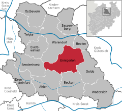 | |
 Ennigerloh  Ennigerloh | |
| Coordinates: 51°50′12″N 8°1′32″E | |
| Country | Germany |
| State | North Rhine-Westphalia |
| Admin. region | Münster |
| District | Warendorf |
| Subdivisions | 4 |
| Government | |
| • Mayor (2020–25) | Berthold Lülf[1] (SPD) |
| Area | |
| • Total | 125.15 km2 (48.32 sq mi) |
| Elevation | 104 m (341 ft) |
| Population (2020-12-31)[2] | |
| • Total | 19,554 |
| • Density | 160/km2 (400/sq mi) |
| Time zone | UTC+01:00 (CET) |
| • Summer (DST) | UTC+02:00 (CEST) |
| Postal codes | 59320 |
| Dialling codes | 02524 (Ennigerloh und Ostenfelde) 02528 (Enniger) 02587 (Westkirchen) |
| Vehicle registration | WAF |
| Website | www.ennigerloh.de |
The town, located in an agricultural area and with a well-preserved medieval quarter, became more industrial in the 20th century as several cement factories were installed. Some of these closed towards the end of the century. Furniture manufacturing was also a significant industry.
Geography
Subdivisions
- Enniger
- Westkirchen
- Ostenfelde
Notable people
- Alois Hanslian (born 1943), painter
- Willy Hartner (1905–1981), professor, founded the Institute for the History of Natural Sciences in Frankfurt am Main
- Karl Weierstrass (1815–1897), mathematician often described as "the father of analysis"
References
- Wahlergebnisse in NRW Kommunalwahlen 2020, Land Nordrhein-Westfalen, accessed 30 June 2021.
- "Bevölkerung der Gemeinden Nordrhein-Westfalens am 31. Dezember 2020" (in German). Landesbetrieb Information und Technik NRW. Retrieved 21 June 2021.
External links
- Official website
 (in German)
Towns and municipalities in Warendorf (district) | ||
|---|---|---|
 | ||
Authority control | |
|---|---|
| General | |
| National libraries | |
| Other |
|
This Warendorf district location article is a stub. You can help Wikipedia by expanding it. |
На других языках
[de] Ennigerloh
Ennigerloh (plattdeutsch Iännigerlau) ist eine kreisangehörige Stadt im Kreis Warendorf im Münsterland mit ungefähr 20.000 Einwohnern. Nachbargemeinden und -städte sind im Uhrzeigersinn, im Norden beginnend: Warendorf, Beelen, Oelde, Beckum, Ahlen und Sendenhorst.- [en] Ennigerloh
[ru] Эннигерло
Эннигерло (нем. Ennigerloh) — город в Германии, в земле Северный Рейн-Вестфалия.Текст в блоке "Читать" взят с сайта "Википедия" и доступен по лицензии Creative Commons Attribution-ShareAlike; в отдельных случаях могут действовать дополнительные условия.
Другой контент может иметь иную лицензию. Перед использованием материалов сайта WikiSort.org внимательно изучите правила лицензирования конкретных элементов наполнения сайта.
Другой контент может иметь иную лицензию. Перед использованием материалов сайта WikiSort.org внимательно изучите правила лицензирования конкретных элементов наполнения сайта.
2019-2026
WikiSort.org - проект по пересортировке и дополнению контента Википедии
WikiSort.org - проект по пересортировке и дополнению контента Википедии