world.wikisort.org - Germany
District 2 (German: Stadtbezirk 2) is a borough of Düsseldorf, the state capital of North Rhine-Westphalia, Germany. The district covers an area of 7.15 square kilometres and (as of December 2020) has about 64,000 inhabitants.[1]
Stadtbezirk 2 | |
|---|---|
Borough of Düsseldorf | |
 Pauluskirche, Düsseldorf-Düsseltal | |
Location of Stadtbezirk 2 within Düsseldorf 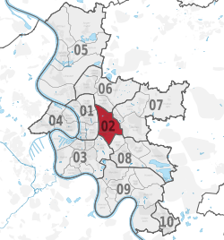 | |
 Stadtbezirk 2  Stadtbezirk 2 | |
| Coordinates: 51°12′29″N 6°46′36″E | |
| Country | Germany |
| State | North Rhine-Westphalia |
| District | Urban district |
| City | Düsseldorf |
| Subdivisions | 3 quarters |
| Area | |
| • Total | 7.15 km2 (2.76 sq mi) |
| Population (2020-12-31)[1] | |
| • Total | 64,183 |
| • Density | 9,000/km2 (23,000/sq mi) |
| Time zone | UTC+01:00 (CET) |
| • Summer (DST) | UTC+02:00 (CEST) |


District 2 is the smallest of all districts in Düsseldorf and next to the central city district 1, it is the only of Düsseldorf's districts to not touch the city limits. Starting clockwise from North-west to South-west, District 2 borders with the following Düsseldorf districts: 1, 6, 7, 8 and 3.
Subdivisions
District 2 is made up of three Stadtteile (city parts):
| # | City part | Population (2009) | Area (km²) | Pop. per km² | |
|---|---|---|---|---|---|
| 021 | Flingern-Nord | 21,290 | 2,70 | 7,885 | |
| 022 | Flingern-Süd | 9,642 | 1,50 | 6,428 | |
| 023 | Düsseltal | 25,616 | 2,98 | 8,596 | |
| source: Amt für Statistik und Wahlen der Landeshauptstadt Düsseldorf (in German) | |||||
Places of interest
Arts, Culture and Entertainment
- Eisstadion, Düsseltal
Landmarks
- Pauluskirche, Düsseltal
Parks and open spaces
- Zoopark
Transportation
The district is served by numerous railway stations and highway.[2] Stations include Düsseldorf Zoo, Düsseldorf Flingern and a dense net of both Düsseldorf Stadtbahn underground- and Rheinbahn tram-stations. The districts can also be reached via Bundesautobahn 57 and Bundesstraße 7 and 8.
See also
- Districts of Düsseldorf
References
- "Stadtgebietsprofile - Stadtbezirke und Stadtteile". Landeshauptstadt Düsseldorf. Retrieved 22 September 2021.
- Urban rail-transitmap Düsseldorf-Meerbusch Archived December 23, 2010, at the Wayback Machine, Verkehrsverbund Rhein-Ruhr
External links
- Official webpage of the district (in German)
Districts of Düsseldorf | ||
|---|---|---|
|  | |
| ||
This Düsseldorf location article is a stub. You can help Wikipedia by expanding it. |
Другой контент может иметь иную лицензию. Перед использованием материалов сайта WikiSort.org внимательно изучите правила лицензирования конкретных элементов наполнения сайта.
WikiSort.org - проект по пересортировке и дополнению контента Википедии