world.wikisort.org - Germany
Braunsbedra (German pronunciation: [bʁaʊ̯nsˈbeːdʁaː] (![]() listen)) is a town in the Saalekreis district, in Saxony-Anhalt, Germany. It is situated approximately 11 km southwest of Merseburg.
listen)) is a town in the Saalekreis district, in Saxony-Anhalt, Germany. It is situated approximately 11 km southwest of Merseburg.
Braunsbedra | |
|---|---|
Town | |
 Coat of arms | |
Location of Braunsbedra within Saalekreis district 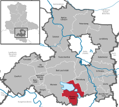 | |
 Braunsbedra  Braunsbedra | |
| Coordinates: 51°17′N 11°54′E | |
| Country | Germany |
| State | Saxony-Anhalt |
| District | Saalekreis |
| Subdivisions | 13 |
| Government | |
| • Mayor (2015–22) | Steffen Schmitz[1] (CDU) |
| Area | |
| • Total | 74.34 km2 (28.70 sq mi) |
| Elevation | 104 m (341 ft) |
| Population (2020-12-31)[2] | |
| • Total | 10,426 |
| • Density | 140/km2 (360/sq mi) |
| Time zone | UTC+01:00 (CET) |
| • Summer (DST) | UTC+02:00 (CEST) |
| Postal codes | 06242 |
| Dialling codes | 034633 |
| Vehicle registration | SK |
| Website | www.braunsbedra.de |
It was created after 1945 by the merger of Braunsdorf and Bedra. The town Braunsbedra consists of Braunsbedra proper and four Ortschaften (municipal divisions): Frankleben, Großkayna, Krumpa and Roßbach.[3]
Roßbach, famous for the Battle of Rossbach, is one of the local communities; the layout of the land had greatly changed since the battle due to lignite mining and then flooding of the abandoned mines to create the Geisel valley Lakes complex.[4]

References
- Bürgermeisterwahlen in den Gemeinden, Endgültige Ergebnisse, Statistisches Landesamt Sachsen-Anhalt, accessed 8 July 2021.
- "Bevölkerung der Gemeinden – Stand: 31. Dezember 2020" (PDF). Statistisches Landesamt Sachsen-Anhalt (in German). June 2021.
- Hauptsatzung der Stadt Braunsbedra, December 2014.
- Geiseltal, Lausitzer und Mitteldeutsche Bergbau-Verwaltungsgesellschaft, p. 10.
Towns and municipalities in the district of Saalekreis | ||
|---|---|---|
 | ||
Authority control | |
|---|---|
| General | |
| National libraries | |
This Saalekreis location article is a stub. You can help Wikipedia by expanding it. |
На других языках
[de] Braunsbedra
Braunsbedra ist eine Stadt im Saalekreis in Sachsen-Anhalt, die im Jahre 1943 aus dem Zusammenschluss der Orte Bedra und Braunsdorf hervorgegangen ist.[3][4]- [en] Braunsbedra
[ru] Браунсбедра
Браунсбедра (нем. Braunsbedra) — город в Германии, в земле Саксония-Анхальт.Текст в блоке "Читать" взят с сайта "Википедия" и доступен по лицензии Creative Commons Attribution-ShareAlike; в отдельных случаях могут действовать дополнительные условия.
Другой контент может иметь иную лицензию. Перед использованием материалов сайта WikiSort.org внимательно изучите правила лицензирования конкретных элементов наполнения сайта.
Другой контент может иметь иную лицензию. Перед использованием материалов сайта WikiSort.org внимательно изучите правила лицензирования конкретных элементов наполнения сайта.
2019-2026
WikiSort.org - проект по пересортировке и дополнению контента Википедии
WikiSort.org - проект по пересортировке и дополнению контента Википедии