world.wikisort.org - Germany
Bad Lauterberg is a town in the district of Göttingen, in Lower Saxony, Germany. It is situated in the southern Harz, approx. 15 km southwest of Braunlage, and 20 km southeast of Osterode am Harz.
Bad Lauterberg | |
|---|---|
Town | |
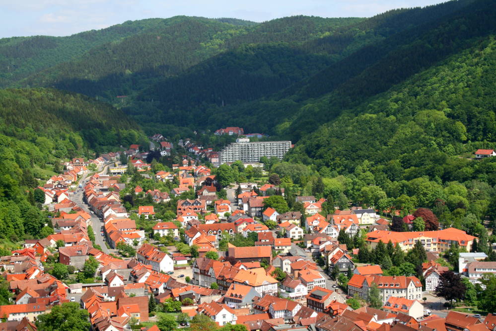 General view of the town | |
 Coat of arms | |
Location of Bad Lauterberg within Göttingen district  | |
 Bad Lauterberg  Bad Lauterberg | |
| Coordinates: 51°37′54″N 10°28′14″E | |
| Country | Germany |
| State | Lower Saxony |
| District | Göttingen |
| Subdivisions | 4 districts |
| Government | |
| • Mayor (2021–26) | Rolf Lange[1] (CDU) |
| Area | |
| • Total | 41.54 km2 (16.04 sq mi) |
| Elevation | 296 m (971 ft) |
| Population (2020-12-31)[2] | |
| • Total | 10,294 |
| • Density | 250/km2 (640/sq mi) |
| Time zone | UTC+01:00 (CET) |
| • Summer (DST) | UTC+02:00 (CEST) |
| Postal codes | 37431 |
| Dialling codes | 05524 |
| Vehicle registration | GÖ, OHA |
| Website | www.badlauterberg.de |
Bad Lauterberg is known inter alia for the liqueurs, Schierker Feuerstein and Harzer Grubenlicht, which are both manufactured and bottled here.
Bad Lauterberg was the birthplace (1879) of the Polar explorer Alfred Ritscher.
Politics
Town council
Town Council after the local elections on September 11, 2016:
- CDU: 6 seats
- Wählergruppe: 5 seats
- SPD: 5 seats
- BI: 2 seats
- Bündnis 90/Die Grünen: 1 seats
- NPD: 1 seat
Sights
About a mile east of the town in the mountains is the viewing point of Hohe Tür which is by a mountain lake and on the main Weser-Elbe watershed. It is checkpoint 43 in the Harzer Wandernadel hiking network.[3]
Notable people
- Alfred Ritscher (1879-1963), captain and Arctic explorer
- Eberhard Umbach (born 1948), German physicist and science manager
- Bibiana Steinhaus (born 1979), football referee
- Tino Schmidt (born 1993), football player
See also
References
- "Stichwahlen zu Direktwahlen in Niedersachsen vom 26. September 2021" (PDF). Landesamt für Statistik Niedersachsen. 13 October 2021.
- Landesamt für Statistik Niedersachsen, LSN-Online Regionaldatenbank, Tabelle A100001G: Fortschreibung des Bevölkerungsstandes, Stand 31. Dezember 2020.
- Stempelstelle 43 / Wasserscheide Weser-Elbe „Hohe Tür“ at www.harzer-wandernadel.de. Retrieved 1 Nov 2017.
External links

Authority control | |
|---|---|
| General | |
| National libraries | |
| Other |
|
This Göttingen district location article is a stub. You can help Wikipedia by expanding it. |
На других языках
- [en] Bad Lauterberg
[ru] Бад-Лаутерберг (Гарц)
Бад-Лаутерберг (нем. Bad Lauterberg) — город в Германии, в земле Нижняя Саксония.Другой контент может иметь иную лицензию. Перед использованием материалов сайта WikiSort.org внимательно изучите правила лицензирования конкретных элементов наполнения сайта.
WikiSort.org - проект по пересортировке и дополнению контента Википедии