world.wikisort.org - Germany
Annaberg-Buchholz (German pronunciation: [ˈanabɛɐ̯k ˈbuːx.hɔlts] (![]() listen)) is a town in Saxony, Germany. Lying in the Ore Mountains, it is the capital of the district of Erzgebirgskreis.
listen)) is a town in Saxony, Germany. Lying in the Ore Mountains, it is the capital of the district of Erzgebirgskreis.
This article may be expanded with text translated from the corresponding article in German. (December 2010) Click [show] for important translation instructions.
|
Annaberg-Buchholz | |
|---|---|
Town | |
 | |
|
Coat of arms | |
Location of Annaberg-Buchholz within Erzgebirgskreis district  | |
 Annaberg-Buchholz  Annaberg-Buchholz | |
| Coordinates: 50°34′48″N 13°0′8″E | |
| Country | Germany |
| State | Saxony |
| District | Erzgebirgskreis |
| Government | |
| • Mayor (2022–29) | Rolf Schmidt[1] (FW) |
| Area | |
| • Total | 27.70 km2 (10.70 sq mi) |
| Elevation | 600 m (2,000 ft) |
| Population (2021-12-31)[2] | |
| • Total | 19,118 |
| • Density | 690/km2 (1,800/sq mi) |
| Time zone | UTC+01:00 (CET) |
| • Summer (DST) | UTC+02:00 (CEST) |
| Postal codes | 09456 |
| Dialling codes | 03733 |
| Vehicle registration | ERZ, ANA, ASZ, AU, MAB, MEK, STL, SZB, ZP |
| Website | www.annaberg-buchholz.de |
Geography
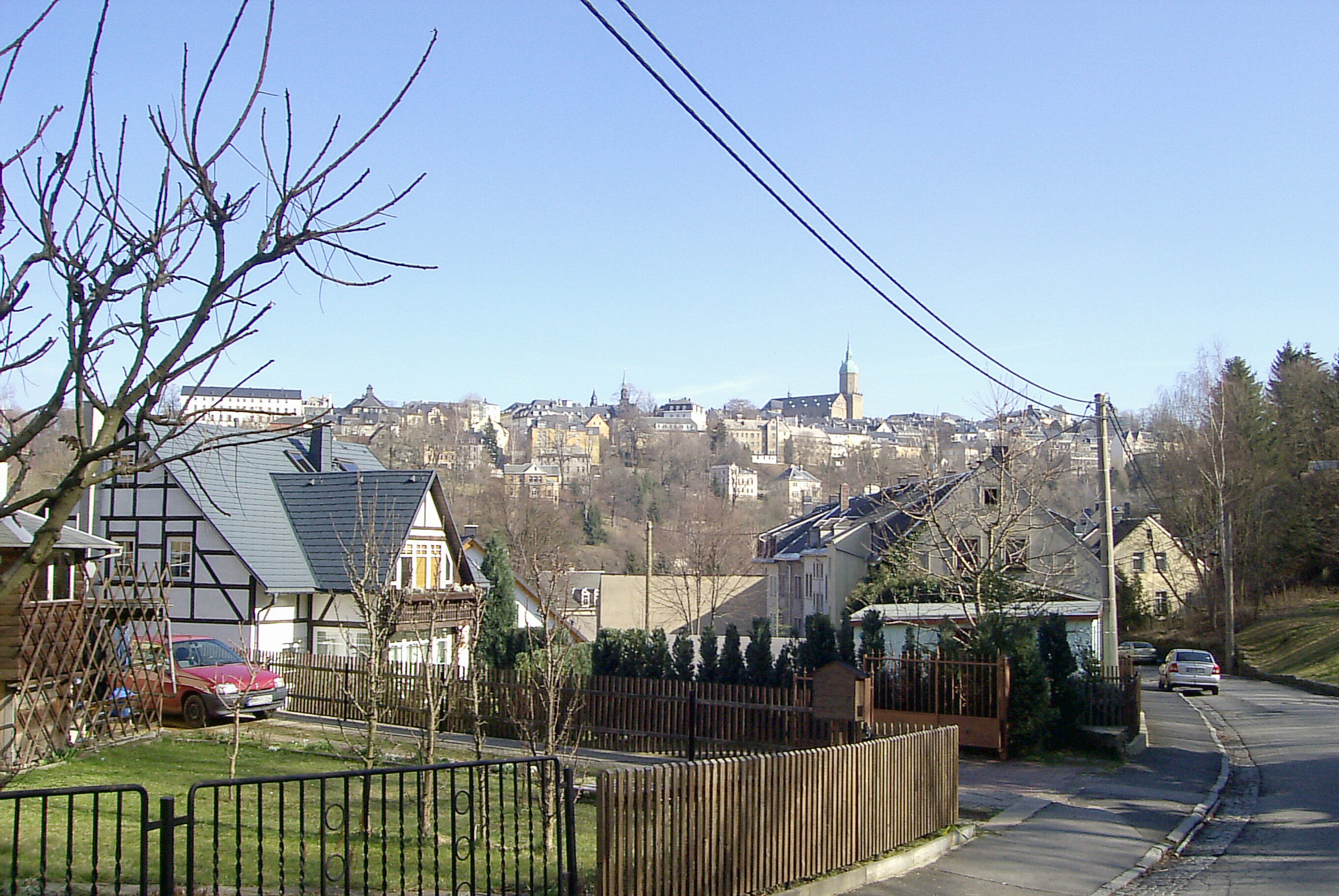
The town is located in the Ore Mountains, at the side of the Pöhlberg (832 meters or 2,730 feet above sea level).
History

The previously heavily forested upper Ore Mountains were settled in the 12th and 13th centuries by Franconian farmers. Frohnau, Geyersdorf, and Kleinrückerswalde—all now part of present-day town—are all attested from 1397.[citation needed]
Barbara Uthmann introduced braid- and lace-making in 1561 and it was further developed in the 1590s by Belgian refugees fleeing the policies of Fernando Álvarez de Toledo, 3rd Duke of Alba, Spain's governor over the Low Countries.[3] The industry was further developed in the 19th century, when Annaberg[4] and Buchholz[5] were connected by rail to Chemnitz and each other and both settlements had specialized schools for lace-making.[4][5] The population of Annaberg in the 1870s was 11,693.[4] This had risen to 16,811 by 1905,[3] with another 9307 in Buchholz.[5]
The town's mines formerly produced silver, tin, and cobalt[4] but ceased production before the First World War.[3] After the Reunification of Germany in 1989, some were restored for tourist purposes.
In 1945 the two towns Annaberg and Buchholz merged into the new town Annaberg-Buchholz. From 1952 to 1990, Annaberg-Buchholz was part of the Bezirk Karl-Marx-Stadt of East Germany.
Historical Population
At the start of the 16th Century Annaberg was one of the largest towns in Germany with an estimated 8,000 inhabitants. In 1834 Annaberg had a population of 5,068 and Buchholz 1,424. In 1875 people lived in Annaberg, in 1890 11,725, in 1925 18,204, and in 1933 19,818. The figures in the table are for Annaberg-Buchholz.
Historical population (from 1960, on 31 December):
|
Pre 1945
|
1946–1981
|
1984–1999
|
2000–2004
|
2005–2009
|
2010–2013
|
- Before 1945: Sum of population of towns Annaberg and Buchholz
Data source 1998: Statistical Office of Saxony
1 29 October
2 31 August
Main sights
This section needs expansion. You can help by adding to it. (June 2008) |
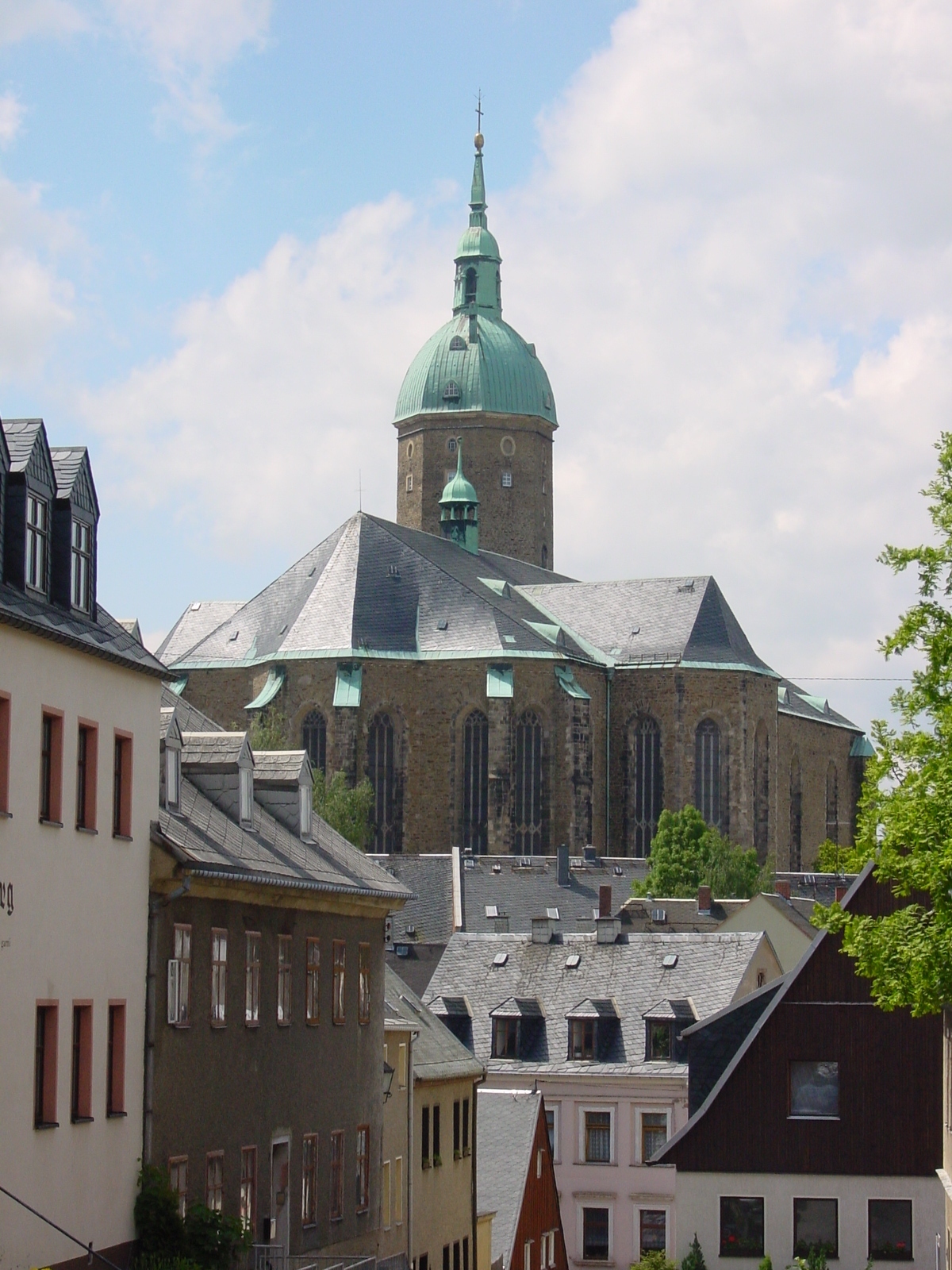
The area is a tourist destination and ski resort. The Ore Mountains are referred to as Land of Christmas and famous for the Christmas Markets and the carved sculptures. Annaberg has a Roman Catholic church and three Protestant churches, among them St. Anne's (built 1499-1525),[3] which is the largest of its kind in Saxony. There are public monuments to Luther, the famous mathematician Adam Ries, and Barbara Uthmann.[3] Buchholz had another Gothic Protestant church and monuments to Frederick the Wise and Bismarck. Annaberg is well known for its historical old town and market square; the house Markt 2 shows the coat of arms of the family Apian-Bennewitz.
Museums
- Adam Ries Museum and Annaberg School of Accountancy (Rechenschule)
- Ore Mountain Museum and Im Gößner visitor mine
- Manufaktur der Träume
- Markus-Röhling-Stolln visitor mine at Frohnau
- Dorothea-Stolln visitor mine at Cunersdorf
Frohnauer Hammer
The Frohnauer Hammer is a historic and fully working preserved hammer mill in the village of Frohnau within the municipality. In 1907, it was declared a technical monument and, since then, has been open to the public. In addition to the actual hammer mill itself, there is an exhibition of forged items and the former master hammersmith's house (Hammerherrenhaus).
Regular events
- An annual high point in early summer is the largest folk festival in the region, the Annaberger Kät.
- Every two years in August the Abbey Festival takes place in the ruins of Annaberg Abbey]
- The Annaberg Christmas Market is widely known outside the region and closes on the fourth week in advent with the world's biggest miners' parade (Bergparade).
Twin towns – sister cities
Annaberg-Buchholz is twinned with:[6]
 Chomutov, Czech Republic
 Paide, Estonia
 Weiden in der Oberpfalz, Germany
Gallery
 St. Anne's Church
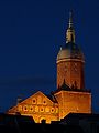 St. Anne's Church
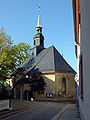 St.Mary's Church
 Uthmann Monument
 Frohnauer Hammer
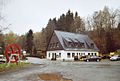 Markus Röhling Stolln
 School building
 Adam Ries Monument
 Panoramic view of the city silhouette


Notable people
- Gabriel Zwilling (1487–1558), Lutheran theologian and reformer
- Barbara Uthmann (1514–1575), born of Elterlein, entrepreneur


- Paul Jenisch (1551–1612), educator and theologian
- David Fletcher (1646–1716), Privy Councillor of Commerce and landowner
- Gottfried Arnold Irenaeus called (1666–1714), poet
- Christian Felix Weiße (1726–1804), founder of the German Children's Literature
- Bernhard Eisenstuck (1805–1871), entrepreneur and politician
- Peter Gast alias Peter Guest (1854–1918), composer, writer, associate of Friedrich Nietzsche and dialect poet
- Walter König (1878–1964), professor of chemistry
- Theodor Korselt (1891–1943), lawyer and Nazi victim
- Paul Schneider (1892–1975), woodcarver
- Erich Lorenz (1894–1981), local historian, folklorist, historian and collector of biographies
- Carl Friedrich Claus (1930–1998), graphic artist, poet and philosopher
- Frank Wiegand (born 1943), swimmer
- Matthias Herget (born 1955), football player
- Evelin Jahl born Schlaak (born 1956), discus thrower
- Ute Noack (born 1961), cross-country skier
- Yvonne Mai-Graham (born 1965), middle-distance runner
- Kathrin Weßel (born 1967), long-distance runner
- Viola Bauer (born 1976), cross-country skier
- Anke Wischnewski (born 1978), luger
- Eric Frenzel (born 1988), Nordic Combined skier
Notes
- Gewählte Bürgermeisterinnen und Bürgermeister im Freistaat Sachsen, Stand: 17. Juli 2022, Statistisches Landesamt des Freistaates Sachsen.
- "Bevölkerung des Freistaates Sachsen nach Gemeinden am 31. Dezember 2021" (XLS) (in German). Statistisches Landesamt des Freistaates Sachsen. 2022.
- EB (1911).
- EB (1878).
- EB (1911b).
- "Partnerstädte". annaberg-buchholz.de (in German). Annaberg-Buchholz. Retrieved 4 November 2020.
References
- Baynes, T. S., ed. (1878), , Encyclopædia Britannica, vol. 2 (9th ed.), New York: Charles Scribner's Sons, p. 60
- Chisholm, Hugh, ed. (1911), , Encyclopædia Britannica, vol. 2 (11th ed.), Cambridge University Press, p. 59
- Chisholm, Hugh, ed. (1911), , Encyclopædia Britannica, vol. 4 (11th ed.), Cambridge University Press, p. 724
External links
- Official website
 (in German)
Borough of Annaberg-Buchholz | ||
|---|---|---|
| ||
Authority control | |
|---|---|
| General | |
| National libraries | |
| Other |
|
На других языках
[de] Annaberg-Buchholz
Annaberg-Buchholz ist eine Große Kreisstadt im sächsischen Erzgebirgskreis. Sie ist die zweitgrößte Stadt des Landkreises und dessen Verwaltungssitz. Die Stadt ist ein überregionales Verwaltungs- und Dienstleistungszentrum, Sitz der Agentur für Arbeit, des Tourismusverbandes und der Wirtschaftsförderungsgesellschaft. Die Altstadt von Annaberg sowie einige der umgebenden historischen Bergbaulandschaften gehören seit 2019 zum UNESCO-Welterbe.[4]- [en] Annaberg-Buchholz
[fr] Annaberg-Buchholz
Annaberg-Buchholz est une ville allemande située dans le sud du Land de Saxe. Elle est le chef-lieu de l'arrondissement des Monts-Métallifères.[it] Annaberg-Buchholz
Annaberg-Buchholz è una città di 19 619 abitanti della Sassonia, in Germania.[ru] Аннаберг-Буххольц
А́ннаберг-Бу́ххольц (нем. Annaberg-Buchholz) — город в Германии, районный центр, расположен в земле Саксония. Подчинён административному округу Хемниц. Входит в состав района Рудные Горы. Население составляет 21831 человек (на 31 декабря 2010 года). Занимает площадь 27,70 км². Официальный код — 14 1 71 010.Другой контент может иметь иную лицензию. Перед использованием материалов сайта WikiSort.org внимательно изучите правила лицензирования конкретных элементов наполнения сайта.
WikiSort.org - проект по пересортировке и дополнению контента Википедии