world.wikisort.org - France
Saint-Élie is a commune of French Guiana, an overseas department and region of France in South America. In 1930, Saint-Élie became capital of the Inini territory.[3] From 1953 onward, the commune was called Centre. In 1969, it was renamed to Saint-Élie.[4]
Saint-Élie | |
|---|---|
Commune | |
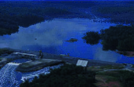
 The Petit-Saut Dam, northeast of the commune, on the border with Sinnamary | |
 Location of the commune (in red) within French Guiana | |
Location of Saint-Élie  | |
| Coordinates: 4°49′22″N 53°16′35″W | |
| Country | France |
| Overseas region and department | French Guiana |
| Arrondissement | Cayenne |
| Intercommunality | CC des Savanes |
| Government | |
| • Mayor (2020–2026) | Véronique Jacaria[1] |
| Area 1 | 5,680 km2 (2,190 sq mi) |
| Population | 247 |
| • Density | 0.043/km2 (0.11/sq mi) |
| Time zone | UTC−03:00 |
| INSEE/Postal code | 97358 /97312 |
| 1 French Land Register data, which excludes lakes, ponds, glaciers > 1 km2 (0.386 sq mi or 247 acres) and river estuaries. | |
History

In 1873, gold was discovered in Saint-Élie. The mines were in the middle of the rain forest with no river connection to the outside world. In 1884 construction began on a Decauville railway line to Gare Tigre near Saint-Nazaire in order to access the Sinnamary River.[5]
The railway line needed frequent repairs, and had over 100 bridges. In 1990, the railway line was abandoned when a road opened.[6] The roads ends near Saint-Nazaire, and a 45 minute ferry to Petit-Saut Dam is needed to reach the outside world.[7]
Gold is still the backbone of the economy. The gold mines are currently being exploited by Newmont Mining Corporation.[8] In 1989, construction started on the Petit-Saut Dam to produce hydroelectric power. The dam was completed in 1994.[9]
Nature
In 1996, La Trinité National Nature Reserve was founded. It covers 76,903 hectares and is primary tropical rain forest located in the heart of the Guyana plateau forest.[10]
Villages
- Saint-Nazaire
See also
References
- "Répertoire national des élus: les maires" (in French). data.gouv.fr, Plateforme ouverte des données publiques françaises. 4 May 2022.
- "Populations légales 2019". The National Institute of Statistics and Economic Studies. 29 December 2021.
- "South America 1930: Vargas Revolution". Omni Atlas. Retrieved 4 June 2020.
- "Mairie Saint-Élie". Mairie Saint-Élie (in French). Retrieved 4 June 2020.
- "Industrial Railways in French Guiana, 2014". International Steam. Retrieved 4 June 2020.
- "Quand la Guyane voulait son chemin de fer" (PDF). Alliance Francophone Internationale du Tourisme et des Voyages (in French). Retrieved 4 June 2020.
- "La barrière de la discorde à Saint-Elie". France TV Info (in French). Retrieved 21 March 2021.
- "CME Announces Agreement with Newmont on its Esperance Project and Seeks a Partner for its Saint-Elie Property in French Guiana". Globe News Wire. Retrieved 4 June 2020.
- "Petit Saut Dam". Structurae.net. Retrieved 4 June 2020.
- "Historique Réserve Naturelle La Trinité" (in French). Retrieved 4 June 2020.
External links
- Official website (in French)
На других языках
[de] Saint-Élie
Saint-Élie ist eine französische Gemeinde mit 247 Einwohnern (Stand 1. Januar 2019) im Übersee-Département Französisch-Guayana im Norden Südamerikas. Von 1930 bis 1946 war sie die Hauptstadt der französischen Kolonie Inini.- [en] Saint-Élie
[es] Saint-Élie
Saint-Élie es una comuna ubicada en el centro-norte de la Guayana Francesa. Tiene un área de 5.680 km² y una población de 420 habitantes (datos de 2011).Другой контент может иметь иную лицензию. Перед использованием материалов сайта WikiSort.org внимательно изучите правила лицензирования конкретных элементов наполнения сайта.
WikiSort.org - проект по пересортировке и дополнению контента Википедии