world.wikisort.org - France
Pierrepont (French pronunciation: [pjɛʁpɔ̃] (![]() listen)) is a commune in the Meurthe-et-Moselle department in north-eastern France.
listen)) is a commune in the Meurthe-et-Moselle department in north-eastern France.
Pierrepont | |
|---|---|
Commune | |
 The town hall in Pierrepont | |
 Coat of arms | |
Location of Pierrepont  | |
 Pierrepont  Pierrepont | |
| Coordinates: 49°24′59″N 5°42′44″E | |
| Country | France |
| Region | Grand Est |
| Department | Meurthe-et-Moselle |
| Arrondissement | Briey |
| Canton | Mont-Saint-Martin |
| Intercommunality | CC Terre Lorraine du Longuyonnais |
| Government | |
| • Mayor (2020–2026) | James Moineaux[1] |
| Area 1 | 7.02 km2 (2.71 sq mi) |
| Population | 863 |
| • Density | 120/km2 (320/sq mi) |
| Time zone | UTC+01:00 (CET) |
| • Summer (DST) | UTC+02:00 (CEST) |
| INSEE/Postal code | 54428 /54620 |
| Elevation | 227–336 m (745–1,102 ft) (avg. 241 m or 791 ft) |
| 1 French Land Register data, which excludes lakes, ponds, glaciers > 1 km2 (0.386 sq mi or 247 acres) and river estuaries. | |
History
During the First World War was from 1915 to 1918 in Ugny was the artillery, in the forest of Doncourt the training ground and in Beuveille has been the headquarter of the Sturm-Bataillon Nr. 5 (Rohr), in Pierrepont has been the hospital and the cemetery.
On the German soldiers cemetery, the dead of the Battalion were mostly buried. The monument, in the shape of a lion guarding the dead, has already been set up during the war and then not eliminated.[3]
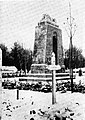 Memorial

See also
Notes
- "Répertoire national des élus: les maires". data.gouv.fr, Plateforme ouverte des données publiques françaises (in French). 2 December 2020.
- "Populations légales 2019". The National Institute of Statistics and Economic Studies. 29 December 2021.
- Eberhard Graf von Schwerin: Königlich preußisches Sturm-Bataillon Nr . 5 (Rohr) (Aus Deutschlands großer Zeit; Band 116) nach der Erinnerung aufgezeichnet unter Zuhilfenahme des Tagebuches von Oberstleutnant a. D. Willi Rohr / Graf v. Schwerin; Verlag Bernhard Sporn, Zeulenroda 1939
Wikimedia Commons has media related to Pierrepont (Meurthe-et-Moselle).
This Meurthe-et-Moselle geographical article is a stub. You can help Wikipedia by expanding it. |
На других языках
- [en] Pierrepont, Meurthe-et-Moselle
[ru] Пьерпон (Мёрт и Мозель)
Пьерпо́н (фр. Pierrepont) — коммуна во французском департаменте Мёрт и Мозель региона Лотарингия. Относится к кантону Лонгийон.Текст в блоке "Читать" взят с сайта "Википедия" и доступен по лицензии Creative Commons Attribution-ShareAlike; в отдельных случаях могут действовать дополнительные условия.
Другой контент может иметь иную лицензию. Перед использованием материалов сайта WikiSort.org внимательно изучите правила лицензирования конкретных элементов наполнения сайта.
Другой контент может иметь иную лицензию. Перед использованием материалов сайта WikiSort.org внимательно изучите правила лицензирования конкретных элементов наполнения сайта.
2019-2025
WikiSort.org - проект по пересортировке и дополнению контента Википедии
WikiSort.org - проект по пересортировке и дополнению контента Википедии