world.wikisort.org - France
Montagudet (French pronunciation: [mɔ̃taɡydɛ]) is a commune in the Tarn-et-Garonne department in the Occitanie region in southern France.
Montagudet | |
|---|---|
Commune | |
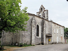
 The church of Saint-Sulpice-de-Bourges, in Montagudet | |
Location of Montagudet  | |
 Montagudet  Montagudet | |
| Coordinates: 44°14′42″N 1°05′32″E | |
| Country | France |
| Region | Occitania |
| Department | Tarn-et-Garonne |
| Arrondissement | Castelsarrasin |
| Canton | Pays de Serres Sud-Quercy |
| Intercommunality | Pays de Serres en Quercy |
| Government | |
| • Mayor (2020–2026) | Jean Benois[1] |
| Area 1 | 12.18 km2 (4.70 sq mi) |
| Population | 194 |
| • Density | 16/km2 (41/sq mi) |
| Time zone | UTC+01:00 (CET) |
| • Summer (DST) | UTC+02:00 (CEST) |
| INSEE/Postal code | 82116 /82110 |
| Elevation | 91–237 m (299–778 ft) (avg. 200 m or 660 ft) |
| 1 French Land Register data, which excludes lakes, ponds, glaciers > 1 km2 (0.386 sq mi or 247 acres) and river estuaries. | |
Geography
The Séoune forms part of the commune's northern border. The Barguelonnette forms most of the commune's southern border.
See also
References
- "Répertoire national des élus: les maires" (in French). data.gouv.fr, Plateforme ouverte des données publiques françaises. 13 September 2022.
- "Populations légales 2019". The National Institute of Statistics and Economic Studies. 29 December 2021.
Wikimedia Commons has media related to Montagudet.
На других языках
[de] Montagudet
Montagudet ist eine französische Gemeinde mit 194 Einwohnern (Stand 1. Januar 2019) im Département Tarn-et-Garonne in der Region Okzitanien (vor 2016 Midi-Pyrénées). Sie gehört zum Arrondissement Castelsarrasin und zum Kanton Pays de Serres Sud-Quercy (bis 2015 Lauzerte). Sie grenzt im Nordwesten an Touffailles, im Nordosten an Lauzerte, im Südosten an Saint-Amans-de-Pellagal, im Süden an Montbarla und im Südwesten an Miramont-de-Quercy. Die Bewohner nennen sich Montagudetois.- [en] Montagudet
[fr] Montagudet
Montagudet est une commune française située dans le nord-ouest du département de Tarn-et-Garonne, en région Occitanie. Sur le plan historique et culturel, la commune est dans le Quercy Blanc, correspondant à la partie méridionale du Quercy, devant son nom à ses calcaires lacustres du Tertiaire.Текст в блоке "Читать" взят с сайта "Википедия" и доступен по лицензии Creative Commons Attribution-ShareAlike; в отдельных случаях могут действовать дополнительные условия.
Другой контент может иметь иную лицензию. Перед использованием материалов сайта WikiSort.org внимательно изучите правила лицензирования конкретных элементов наполнения сайта.
Другой контент может иметь иную лицензию. Перед использованием материалов сайта WikiSort.org внимательно изучите правила лицензирования конкретных элементов наполнения сайта.
2019-2025
WikiSort.org - проект по пересортировке и дополнению контента Википедии
WikiSort.org - проект по пересортировке и дополнению контента Википедии